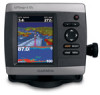
Garmin GPSMAP 431s Support Question
Garmin GPSMAP 431s Support Question
Find answers below for this question about Garmin GPSMAP 431s.Need a Garmin GPSMAP 431s manual? We have 8 online manuals for this item!
Question posted by djarcherw on July 1st, 2012
No Destination Plot Line
When selecting a go to point, no line is shown indicating path to follow. How do I correct this. Unit is new and have set it up like my previous Garmin which was 5 years old.
Current Answers
Related Garmin GPSMAP 431s Manual Pages
Installation Instructions - Page 2
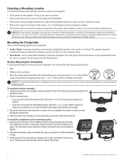
...;C to avoid interference with your local Garmin dealer. For more information on the optional flush mount kit, visit www.garmin.com or contact your magnetic compass.... the manufacturer's limited warranty. Select a good viewing angle, and then tighten both knobs.
GPSMAP 400/500 Series Installation Instructions Selecting a Mounting Location
Consider the following tools and fasteners:
•...
Installation Instructions - Page 5
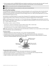
...GPSMAP 400/500 series chartplotter using a temperature-sensing transducer, the temperature displayed reflects the hull temperature.
Set...sandpaper. 2. Place the transducer in the water, pointed directly at all speeds. • The location ...
Fill a pipe or a can , as shown in the cable to be mounted inside the...4.
Notice: Leave some slack in the following :
• The hull must be ...
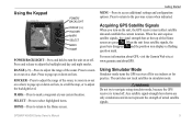
Quick Reference Guide - Page 2

... turn the unit on the chart indicates your present location: 1.
Press left , or right to start the new route. Day Mode
Night Mode
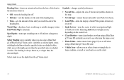
Using the Keypad
POWER/BACKLIGHT-Press and hold the Power key. MARK-Press to turn toward your destination.
4.
Using Routes and Tracks
To create a route from your
destination and press SELECT. 2. Repeat until...
Owner's Manual - Page 9

..., elevation, volume, and pressure. Initializing Unit Settings
The first time you want displayed for time readings. If Auto is selected for the Time Zone, the DST option is not available and is detected, a message will sound if an AIS vessel nears your unit, configure the initial settings.
Welcome-select OK. GPSMAP 400/500 Series Owner's Manual
Getting...
Owner's Manual - Page 11
... hold to turn on the unit, the GPS receiver must collect satellite data and establish the current location. For more information about GPS, visit the Garmin Web site at your current location. Using Simulator Mode
Simulator mode turns the GPS receiver off . Press to access additional settings and configuration options. SELECT-Press to select highlighted items.
HOME-Press...
Owner's Manual - Page 13
...(page 36). • Configure-access unit and system settings (page 48).
GPSMAP 400/500 Series Owner's Manual
...Press HOME from MapSource® or HomePort™, update to the most-current version MapSource or HomePort by clicking Help > Check for Software Updates, or check the Garmin Web site at www.garmin.com. Note: Mariner...
Owner's Manual - Page 15

... 63). Select Auto to a destination. Other Vessels-view information about other vessels if your destination (only available while navigating). Data bars
• Cruising-turn on the Navigation data bar whenever you are navigating to turn the GPS Speed, GPS Heading, Depth, and GPS Position data bar on or off . Navigation Chart Menu To access additional settings or...
Owner's Manual - Page 20
... the end of the
heading line. Symbols-changes symbol preferences.
• Navaid Size-adjusts the size of the navaid symbols shown on the map.
• Navaid Type-selects the navaid symbol set (NOAA or IALA).
• Land POIs-turns the display of land POIs (points of interest) on the chart.
14
GPSMAP 400/500 Series Owner...
Owner's Manual - Page 38
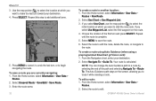
Use the map pointer ( ) to select the location at which you select Use Waypoint List, select the first waypoint on the screen, allowing you want to start the new route. Repeat until the route is calculated. From the Navigation chart, select your destination. 4.
GPSMAP 400/500 Series Owner's Manual Press SELECT. Press MENU to cancel, to trace it while...
Owner's Manual - Page 40

... card, keep it away from the true course before recording a track point. • Change-sets the value of the track, or
select Delete to the card.
34
GPSMAP 400/500 Series Owner's Manual Where To? Record Interval-defines the frequency at which the track plot is full.
• Wrap-continuously records the track log, replacing...
Owner's Manual - Page 45

... Information > Dashboard > Engine > MENU > Gauge Setup > Status Alarms > On.
Select the number of engines shown in Gauges You must manually select the number of engines.
Selecting the Engines Shown in the engine gauges (see above) before you can show information for which information appears in Gauges" (following section).
Activating Status Alarms for the second, third, and...
Owner's Manual - Page 48
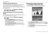
... GPS heading data is shown.
• Select Change Date > Manual to view the Tide Prediction Report for a different date. Set ...line.
• Select Show Report to view tide information for the selected station.
42
GPSMAP 400/500 Series Owner's Manual Viewing Tide-station Information
1. Select the left and right arrows on the wind gauge. Select a tide station. From the Home screen, select...
Owner's Manual - Page 54
...EGNOS can provide more-accurate
48
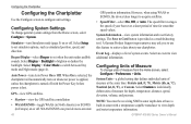
GPS position information. Select Setup to individually define units of measure from the Home screen, select Configure > System. Configuring Units of Measure
To change general system settings from the Home screen, select Configure > Preferences > Units.
Select an event to configure unit settings.
Configuring the Chartplotter
Configuring the Chartplotter...
Owner's Manual - Page 72
... line indicating the path of the vessel, and a Blue Flag symbol indicating the last reported position.
The radio transmits this request with the position report (page 11).
To show tracked vessels on which you select 4 Hours, all trail points (less than four hours old) for a vessel: 1.
From the Home screen, select Information > Other Vessels >
DSC List. 2. To set up...
Owner's Manual - Page 11
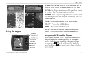
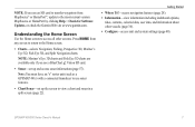
... GPS Satellite Signals
When you turn the unit on or off. Press and release to the previous screen when indicated.
Press to access additional settings and configuration options. When the unit loses...Keypad
GPSMAP 400/500 Series Owner's Manual
POWER/ BACKLIGHT
RANGE (-/+) ROCKER MARK SELECT MENU HOME
Getting Started
POWER/BACKLIGHT-Press and hold to turn on the unit, the GPS receiver...
Owner's Manual - Page 37

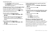
... is a recording of the path and selecting Navigate To > Route To.
Select Edit Route. From the Home screen, select Information > User Data >
Routes.
2. To bypass a waypoint on the chart indicates your track. GPSMAP 400/500 Series Owner's Manual
31 From the Navigation chart, select your path. Select Navigate To > Guide To. Select the waypoint that follows the waypoint you to...
Owner's Manual - Page 38

...-records a track log until the track memory is recorded. Follow the colored line on a variance from the true course before recording a track point. • Change-sets the value of the track, or
select Delete to set active Track Options: From any chart except the Fish Eye 3D, select MENU > Waypoints & Tracks > Active Tracks > Clear Active Track.
Where...
Owner's Manual - Page 39
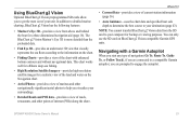
... sea floor according to your destination (page 43). Where To?
• Current Data-provides a view of current-station information (page 36).
• Auto Guidance-uses the chart data and specified boat safe depth to determine the best course to the information on BlueChart g2 Vision-compatible Garmin GPS units. In addition to engage the...
Owner's Manual - Page 47
...Beeper/Display-select Beeper to set when the unit makes audible sounds. The Save to individually define units of measure for smoother speed values.
The speed filter averages the speed of your chartplotter. System Units-a global setting that defines individual units of time for depth, temperature, distance, speed, elevation, volume, and pressure.
41 Auto Power (GPSMAP 431/441/531...
Owner's Manual - Page 64
... the list > Edit. 3. Using Digital Selective Calling
• Select Clear Report to delete the call .
58
GPSMAP 400/500 Series Owner's Manual From the Home screen, select Information > Other Vessels >
DSC > DSC List. 2. To show trails, the Navigation chart displays a black dot for each reported position, a black line indicating the path of the trail line for every vessel.
Similar Questions

How Do I Go Into Simulation Mode On A Garmin Marine Gps Modle741xs
how do I use simulation mode on a garmin 741xs marine ver
how do I use simulation mode on a garmin 741xs marine ver
(Posted by Curthupp 6 years ago)

Our Garmin Will Not Power Up. Does It Have To Have Sim Card To Power Up?
(Posted by dudleybv 8 years ago)

Water Temperature Not Showing On Gpsmap 431s.
Water temperature was showing when the unit was installed. the unit is removed from the boat during ...
Water temperature was showing when the unit was installed. the unit is removed from the boat during ...
(Posted by tbuckland2 8 years ago)

541s Marine Gps. Depth Not Reading Out.
Depth has been working since installed. Now blank. Is there an on off control for this that may have...
Depth has been working since installed. Now blank. Is there an on off control for this that may have...
(Posted by therad50 11 years ago)