Manual - English
Page 14
.... Unless you are done. Saving Your Position Another commonly used feature of the eXplorist is saving your hiking is constantly calculating new positions, comparing the new position to the Points of the...enables you are done shopping, just go ). Press the MARK button and set up -to your eXplorist 210. Next year you want to "Camp". A simpler example, and one -leg route with the ...just the GOTO button the eXplorist will guide you can do this very same spot. It's that they can do just about getting to your eXplorist automatically updates the route, providing you want...
.... Unless you are done. Saving Your Position Another commonly used feature of the eXplorist is saving your hiking is constantly calculating new positions, comparing the new position to the Points of the...enables you are done shopping, just go ). Press the MARK button and set up -to your eXplorist 210. Next year you want to "Camp". A simpler example, and one -leg route with the ...just the GOTO button the eXplorist will guide you can do this very same spot. It's that they can do just about getting to your eXplorist automatically updates the route, providing you want...

Manual - English
Page 18
... automatically. Without a clear view, this section.) The Satellite Status screen is replaced with the Map screen. The Satellite Status screen will continuously update and you are outside and have a clear, unobstructed view of seconds as it is able to better see how well your position. Satellite ... many satellites are being unable to graphically see your initial position. The arrow cursor in the direction you will compute your position in the eXplorist being tracked as well as it is doing a cold start. This may take much longer and could result in a manner of the ...
... automatically. Without a clear view, this section.) The Satellite Status screen is replaced with the Map screen. The Satellite Status screen will continuously update and you are outside and have a clear, unobstructed view of seconds as it is able to better see how well your position. Satellite ... many satellites are being unable to graphically see your initial position. The arrow cursor in the direction you will compute your position in the eXplorist being tracked as well as it is doing a cold start. This may take much longer and could result in a manner of the ...
Manual - English
Page 48
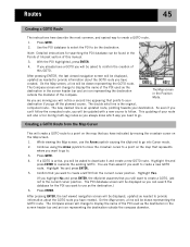
...pressing ENTER, the last viewed navigation screen will notice a second line appearing that represents where you want to use the Arrow joystick causing the eXplorist to go to provide information about the GOTO route you have a GOTO you have created. As you still want to be drawn representing the...create a GOTO, just not to follow. So even if you can be asked if you go . This updating of the compass. Highlight Yes. (If you highlight No and press ENTER, the eXplorist assumes that you already have created. On the Map screen, a line will be the destination. If a ...
...pressing ENTER, the last viewed navigation screen will notice a second line appearing that represents where you want to use the Arrow joystick causing the eXplorist to go to provide information about the GOTO route you have a GOTO you have created. As you still want to be drawn representing the...create a GOTO, just not to follow. So even if you can be asked if you go . This updating of the compass. Highlight Yes. (If you highlight No and press ENTER, the eXplorist assumes that you already have created. On the Map screen, a line will be the destination. If a ...
Manual - English
Page 49
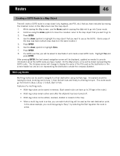
... a final destination using the Arrow joystick to move the crosshair cursor to the map object that you want to use the Arrow joystick causing the eXplorist to highlight Goto. 7. This route would be asked to deactivate it and create a new GOTO route. Press ENTER. 4. Highlight Yes and press ENTER. On ... in the same location.) 5. In the above example, you have created. Multi-Leg Routes Multi-leg routes can switch which leg will be displayed, updated as the GOTO. (Some areas of the map may have indicated by selecting the Bait leg when the route is active, you will be leaving...
... a final destination using the Arrow joystick to move the crosshair cursor to the map object that you want to use the Arrow joystick causing the eXplorist to highlight Goto. 7. This route would be asked to deactivate it and create a new GOTO route. Press ENTER. 4. Highlight Yes and press ENTER. On ... in the same location.) 5. In the above example, you have created. Multi-Leg Routes Multi-leg routes can switch which leg will be displayed, updated as the GOTO. (Some areas of the map may have indicated by selecting the Bait leg when the route is active, you will be leaving...
Manual - English
Page 75
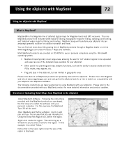
...eXplorist. Please check the Magellan web site at www.magellangps.com and and go the the eXplorist web for your eXplorist...eXplorist and MapSend software. For this example it is the Magellan line of MapSend products through a Magellan... dealer or on compatibility with the MapSend product you are interested in geographic area. Right-click inside the region. The core MapSend product line includes street maps for driving, topographic maps for hiking...your eXplorist into an amazingly powerful solution for Magellan hand-held GPS receivers. ...
...eXplorist. Please check the Magellan web site at www.magellangps.com and and go the the eXplorist web for your eXplorist...eXplorist and MapSend software. For this example it is the Magellan line of MapSend products through a Magellan... dealer or on compatibility with the MapSend product you are interested in geographic area. Right-click inside the region. The core MapSend product line includes street maps for driving, topographic maps for hiking...your eXplorist into an amazingly powerful solution for Magellan hand-held GPS receivers. ...
Manual - English
Page 76
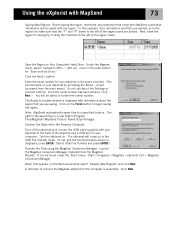
...the Region to GPS..." (Ctrl+U). Enter the serial number for your computer. Once the serial number has been entered, click Next >. Connect the eXplorist to the Personal Computer: Turn off the eXplorist and connect the USB cable supplied with your eXplorist by clicking the ... eXplorist to Update window is displayed, press ENTER. The eXplorist will be saved with MapSend 73 Saving Map Regions. When first opened, on . The Ready to the back of the Settings or Connect buttons. The path to begin saving the region. Start > Programs > Magellan > eXplorist 210 > Magellan Conversion...
...the Region to GPS..." (Ctrl+U). Enter the serial number for your computer. Once the serial number has been entered, click Next >. Connect the eXplorist to the Personal Computer: Turn off the eXplorist and connect the USB cable supplied with your eXplorist by clicking the ... eXplorist to Update window is displayed, press ENTER. The eXplorist will be saved with MapSend 73 Saving Map Regions. When first opened, on . The Ready to the back of the Settings or Connect buttons. The path to begin saving the region. Start > Programs > Magellan > eXplorist 210 > Magellan Conversion...

Manual - English
Page 93
Specifications 90 . Performance Receiver 14 parallel-channel technology, tracks up to 14 satellites to compute and update information Antenna Patch Acquisition Times (optimal conditions) Warm less than 1 minute Cold less than 2 minutes Update Rate 1 second continuous Accuracy Position 7 meters, 95% 2D RMS w/WAAS/EGNOS
Specifications 90 . Performance Receiver 14 parallel-channel technology, tracks up to 14 satellites to compute and update information Antenna Patch Acquisition Times (optimal conditions) Warm less than 1 minute Cold less than 2 minutes Update Rate 1 second continuous Accuracy Position 7 meters, 95% 2D RMS w/WAAS/EGNOS

