Manual - English
Page 64
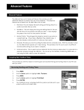
... Fishing Times 1. Use the Arrow joystick to highlight Adv. Use the Arrow joystick to highlight Fish/Hunt. 5. Features. 3. With the simulator turned on, the eXplorist will display the rising and setting times for the sun and the moon for a position and date that you enter. • Sun/Moon: This will... This is displayed with the position and date set your active or a saved track log. (If you have saved.) • Simulate: Provides you have a MapSend Topo detailed map, it was moving. This provides a tool for any position and date you desire when it is connected to your...
... Fishing Times 1. Use the Arrow joystick to highlight Adv. Use the Arrow joystick to highlight Fish/Hunt. 5. Features. 3. With the simulator turned on, the eXplorist will display the rising and setting times for the sun and the moon for a position and date that you enter. • Sun/Moon: This will... This is displayed with the position and date set your active or a saved track log. (If you have saved.) • Simulate: Provides you have a MapSend Topo detailed map, it was moving. This provides a tool for any position and date you desire when it is connected to your...
Manual - English
Page 75
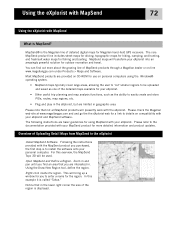
The core MapSend product line includes street maps for driving, topographic maps for hiking, camping, and hunting, and fresh/salt water maps for using the Windows® operating system. • MapSend maps typically cover large areas, allowing the user to 'cut' smaller regions to be ...on -line www.magellangps.com under Products > Maps and Software. The following instructions are provided on CD-ROM for Magellan hand-held GPS receivers. Please refer to the eXplorist Install MapSend Software. Overview of the detailed maps available for outdoor recreation and travel. This will...
The core MapSend product line includes street maps for driving, topographic maps for hiking, camping, and hunting, and fresh/salt water maps for using the Windows® operating system. • MapSend maps typically cover large areas, allowing the user to 'cut' smaller regions to be ...on -line www.magellangps.com under Products > Maps and Software. The following instructions are provided on CD-ROM for Magellan hand-held GPS receivers. Please refer to the eXplorist Install MapSend Software. Overview of the detailed maps available for outdoor recreation and travel. This will...
Manual - English
Page 76
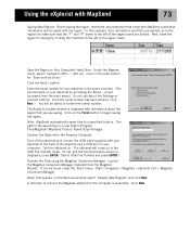
...Magellan > eXplorist 210 > Magellan Conversion Manager. Click Next. Under the Regions menu, select "Upload to a specified location. The path to begin saving the region. Enter the serial number for your computer. Do not use any of the region name are wanted, so in the space provided. In this example, Topo...region name. Note: MapSend automatically saves files to GPS..." (Ctrl+U). A reminder to connect the Magellan eXplorist to confirm the serial number. Next, mark the region for "Save on the Welcome window select 'Transfer Map Regions' and click Next. Save the Region ...
...Magellan > eXplorist 210 > Magellan Conversion Manager. Click Next. Under the Regions menu, select "Upload to a specified location. The path to begin saving the region. Enter the serial number for your computer. Do not use any of the region name are wanted, so in the space provided. In this example, Topo...region name. Note: MapSend automatically saves files to GPS..." (Ctrl+U). A reminder to connect the Magellan eXplorist to confirm the serial number. Next, mark the region for "Save on the Welcome window select 'Transfer Map Regions' and click Next. Save the Region ...
Manual - English
Page 84
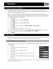
...Units of Measure The eXplorist can provide more detailed street information, additional POIs, and if using on of the MapSend topographic software packages, topo details. Press MENU. 2. Use the Arrow joystick to use one saved. 1. Press ENTER. You can use Active Setup to select the background map you want to ...you have one of measure for Nav Units. 7. Preferences 81 Selecting the Background or Detail Map The eXplorist comes with the new Nav Units shown. You can use Active Setup to select the detail map you want to display navigation data in Miles/Yd/MPH, Miles/Ft/MPH, NM/Ft/...
...Units of Measure The eXplorist can provide more detailed street information, additional POIs, and if using on of the MapSend topographic software packages, topo details. Press MENU. 2. Use the Arrow joystick to use one saved. 1. Press ENTER. You can use Active Setup to select the background map you want to ...you have one of measure for Nav Units. 7. Preferences 81 Selecting the Background or Detail Map The eXplorist comes with the new Nav Units shown. You can use Active Setup to select the detail map you want to display navigation data in Miles/Yd/MPH, Miles/Ft/MPH, NM/Ft/...
User Manual
Page 4
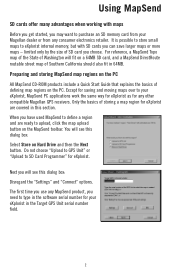
... this dialog box: Disregard the "Settings" and "Connect" options. It is possible to store small maps to eXplorist internal memory, but with maps Before you get started, you may want to SD Card Programmer" for any other compatible Magellan GPS receivers. For reference, a MapSend Topo map of the State of Southern California should also fit in the Target...
... this dialog box: Disregard the "Settings" and "Connect" options. It is possible to store small maps to eXplorist internal memory, but with maps Before you get started, you may want to SD Card Programmer" for any other compatible Magellan GPS receivers. For reference, a MapSend Topo map of the State of Southern California should also fit in the Target...


