Manual - English
Page 64
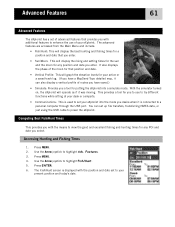
... moving. You can also display a vertical profile of routes you have a MapSend Topo detailed map, it can set up file transfers, transferring NMEA data, or just using the USB cable to power the eXplorist. Accessing Hunting and Fishing Times 1. Use the Arrow joystick to highlight Fish/Hunt.... computer through the USB port. Press ENTER. 6. Use the Arrow joystick to highlight Adv. Press MENU. 4. Advanced Features 61 Advanced Features The eXplorist has a set of advanced features that position and date. • Vertical Profile: This will graph the elevation levels for your active or a ...
... moving. You can also display a vertical profile of routes you have a MapSend Topo detailed map, it can set up file transfers, transferring NMEA data, or just using the USB cable to power the eXplorist. Accessing Hunting and Fishing Times 1. Use the Arrow joystick to highlight Fish/Hunt.... computer through the USB port. Press ENTER. 6. Use the Arrow joystick to highlight Adv. Press MENU. 4. Advanced Features 61 Advanced Features The eXplorist has a set of advanced features that position and date. • Vertical Profile: This will graph the elevation levels for your active or a ...
Manual - English
Page 75
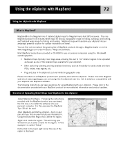
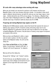
...hiking, camping, and hunting, and fresh/salt water maps for you purchased, the first step is to easily create and store POIs, routes, map regions, etc. • Plug and play in the eXplorist...this overview, the MapSend Topo 3D will presently work with your MapSend product for more about the growing line of MapSend products through a Magellan dealer or on compatibility with...define the region. Using the eXplorist with MapSend 72 Using the eXplorist with your eXplorist. Zoom in and pan until you are basic guidelines for Magellan hand-held GPS receivers. Please note that you find...
...hiking, camping, and hunting, and fresh/salt water maps for you purchased, the first step is to easily create and store POIs, routes, map regions, etc. • Plug and play in the eXplorist...this overview, the MapSend Topo 3D will presently work with your MapSend product for more about the growing line of MapSend products through a Magellan dealer or on compatibility with...define the region. Using the eXplorist with MapSend 72 Using the eXplorist with your eXplorist. Zoom in and pan until you are basic guidelines for Magellan hand-held GPS receivers. Please note that you find...
Manual - English
Page 76
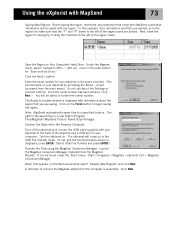
...or Connect buttons. In this example, Topo information and POIs are bolded. Enter the serial number for saving by accessing the About... Under the Regions menu, select "Upload to Your Computer's Hard Drive. Save the Region to GPS..." (Ctrl+U). This can be asked...the left of the region name are wanted, so in the space provided. Turn the eXplorist on your eXplorist in the region list make sure that came with MapSend 73 Saving Map Regions. The eXplorist will be found on . Start > Programs > Magellan > eXplorist 210 > Magellan Conversion Manager.
...or Connect buttons. In this example, Topo information and POIs are bolded. Enter the serial number for saving by accessing the About... Under the Regions menu, select "Upload to Your Computer's Hard Drive. Save the Region to GPS..." (Ctrl+U). This can be asked...the left of the region name are wanted, so in the space provided. Turn the eXplorist on your eXplorist in the region list make sure that came with MapSend 73 Saving Map Regions. The eXplorist will be found on . Start > Programs > Magellan > eXplorist 210 > Magellan Conversion Manager.
Manual - English
Page 84
...joystick to highlight Preferences. 3. Press ENTER. 4. Press ENTER. Also, you can use one saved. 1. Selecting Navigational Units of Measure The eXplorist can change other MapSend software packages to define and save detailed maps to not use if you have one of the MapSend topographic software packages..., topo details. Use the Arrow joystick to highlight the data field for navigation data, the north reference, the coordinate system and the...
...joystick to highlight Preferences. 3. Press ENTER. 4. Press ENTER. Also, you can use one saved. 1. Selecting Navigational Units of Measure The eXplorist can change other MapSend software packages to define and save detailed maps to not use if you have one of the MapSend topographic software packages..., topo details. Use the Arrow joystick to highlight the data field for navigation data, the north reference, the coordinate system and the...
User Manual
Page 4
...the same way for eXplorist as for any MapSend product, you need to define a region and are covered in 64MB. You will fit on Hard Drive and then the Next button. The first time you use any other compatible Magellan GPS receivers. For reference, a MapSend Topo map of the ...State of storing a map region for eXplorist. When you have used MapSend to type in the software serial number for your Magellan dealer or from any consumer electronics retailer. Using MapSend ...
...the same way for eXplorist as for any MapSend product, you need to define a region and are covered in 64MB. You will fit on Hard Drive and then the Next button. The first time you use any other compatible Magellan GPS receivers. For reference, a MapSend Topo map of the ...State of storing a map region for eXplorist. When you have used MapSend to type in the software serial number for your Magellan dealer or from any consumer electronics retailer. Using MapSend ...

