Manual - English
Page 2
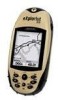
... Magellan eXplorist while driving. Accuracy can also be injured. You may not use of non-Magellan cables and antennas may be affected by the U.S. USE PROPER ACCESSORIES Use only Magellan ...modify, reverse engineer or transfer this guide may severely degrade performance or damage the receiver, and will void the warranty. The SOFTWARE is the property of Thales and/or its suppliers. * * * No ... change any other than the purchaser's personal use the software supplied in and with Thales Navigation GPS products (the "SOFTWARE") in the normal operation of the equipment in accordance ...
... Magellan eXplorist while driving. Accuracy can also be injured. You may not use of non-Magellan cables and antennas may be affected by the U.S. USE PROPER ACCESSORIES Use only Magellan ...modify, reverse engineer or transfer this guide may severely degrade performance or damage the receiver, and will void the warranty. The SOFTWARE is the property of Thales and/or its suppliers. * * * No ... change any other than the purchaser's personal use the software supplied in and with Thales Navigation GPS products (the "SOFTWARE") in the normal operation of the equipment in accordance ...

Manual - English
Page 13
... that your eXplorist will use the GPS satellites to ... that the eXplorist is not being...receive the signals from where you are called 3D position fixes. Do: • Point the antenna up towards the sky. • Maintain a clear view of your hand or other objects. • Point the antenna down. • Stand under trees or other heavy foliage. When you are being computed. Using the eXplorist 210... 10 The eXplorist 210 uses information from the GPS satellites orbiting...better view of your eXplorist. Going to the ...eXplorist will graphically see the satellites and...
... that your eXplorist will use the GPS satellites to ... that the eXplorist is not being...receive the signals from where you are called 3D position fixes. Do: • Point the antenna up towards the sky. • Maintain a clear view of your hand or other objects. • Point the antenna down. • Stand under trees or other heavy foliage. When you are being computed. Using the eXplorist 210... 10 The eXplorist 210 uses information from the GPS satellites orbiting...better view of your eXplorist. Going to the ...eXplorist will graphically see the satellites and...
Manual - English
Page 14
... button and set up -to-date information about any point of Interest database. After your hiking is finding your destination. Next year you can follow these instructions exactly. A simpler example,...option of leaving a trail of other cars in the future when accessing it from your eXplorist 210. This is as simple as heading and speed. This database has two main options; ...but the simplest and most commonly used feature of the eXplorist is accessed by using the Points of interest stored in the eXplorist's software communicating with the name "Car". From that it ...
... button and set up -to-date information about any point of Interest database. After your hiking is finding your destination. Next year you can follow these instructions exactly. A simpler example,...option of leaving a trail of other cars in the future when accessing it from your eXplorist 210. This is as simple as heading and speed. This database has two main options; ...but the simplest and most commonly used feature of the eXplorist is accessed by using the Points of interest stored in the eXplorist's software communicating with the name "Car". From that it ...
Manual - English
Page 33
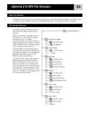
... It is based on a GPS receiver. The files for POIs, routes, track logs and geocaching points are going to modify any of the files, you should do so to a copy of the file structure that is internal to access the file. eXplorist 210 GPS File Structure 30 Basic File ...Structure The eXplorist has a file structure system that is unlike any other filing system used before on the file system that you are probably familiar with from the Magellan Geocaching software.
... It is based on a GPS receiver. The files for POIs, routes, track logs and geocaching points are going to modify any of the files, you should do so to a copy of the file structure that is internal to access the file. eXplorist 210 GPS File Structure 30 Basic File ...Structure The eXplorist has a file structure system that is unlike any other filing system used before on the file system that you are probably familiar with from the Magellan Geocaching software.
Manual - English
Page 36
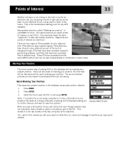
...software, and POIs that have been uploaded from the same MENU option and can go back to them in the future. Waypoints and points of interest are identical.) There are four types of POIs available for your eXplorist 210...last elevation that was not computed, that a elevation value is the fundamental starting point for any GPS navigator. Select the file to save the POI in and press ENTER. These POIs are accessed ...POI's. (You may have been stored in your eXplorist as part of the POI. Points of Interest 33 Whether driving in a car, hiking on the trail or out for an afternoon sail...
...software, and POIs that have been uploaded from the same MENU option and can go back to them in the future. Waypoints and points of interest are identical.) There are four types of POIs available for your eXplorist 210...last elevation that was not computed, that a elevation value is the fundamental starting point for any GPS navigator. Select the file to save the POI in and press ENTER. These POIs are accessed ...POI's. (You may have been stored in your eXplorist as part of the POI. Points of Interest 33 Whether driving in a car, hiking on the trail or out for an afternoon sail...
Manual - English
Page 66
... active track log or one you move the displayed profile left or right. As you have loaded a detail map from one of the MapSend Topographic software packages, you can also view the vertical profile for the selected item is correct, press ENTER. Press ENTER. 6. Up/Down changes the data at the...
... active track log or one you move the displayed profile left or right. As you have loaded a detail map from one of the MapSend Topographic software packages, you can also view the vertical profile for the selected item is correct, press ENTER. Press ENTER. 6. Up/Down changes the data at the...
Manual - English
Page 68
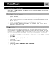
...eXplorist will display the USB File Transfer screen, indicating that the eXplorist is already displayed. NMEA Data Comm mode outputs the GPS data from the eXplorist...cable to any of the USB ports on the back of the eXplorist. 3. Features. 4. Press ENTER. File Transfer mode allows you...Power Only. 8. Turn the eXplorist off data communication with the personal computer and the eXplorist operates normally. 1. Turn the eXplorist on your eXplorist connected to a personal computer ... three modes that the eXplorist can be in. If the eXplorist has just been turned on, the USB File ...
...eXplorist will display the USB File Transfer screen, indicating that the eXplorist is already displayed. NMEA Data Comm mode outputs the GPS data from the eXplorist...cable to any of the USB ports on the back of the eXplorist. 3. Features. 4. Press ENTER. File Transfer mode allows you...Power Only. 8. Turn the eXplorist off data communication with the personal computer and the eXplorist operates normally. 1. Turn the eXplorist on your eXplorist connected to a personal computer ... three modes that the eXplorist can be in. If the eXplorist has just been turned on, the USB File ...
Manual - English
Page 70
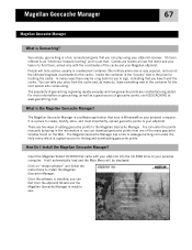
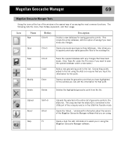
...computer. How Do I Install the Magellan Geocache Manager? Click on "Install software" and follow the instructions to find them, armed only with your eXplorist into the CD-ROM drive on your personal computer. The Magellan Geocache Manager is a software application that is installed, you can...geocache points, visit GEOCACHING at www.geocaching.com. Magellan Geocache Manager 67 Magellan Geocache Manager What is a fun, recreational game that you can play using your eXplorist receiver. For more information on the Web. Insert the Magellan Wizard CD-ROM that . You can take ...
...computer. How Do I Install the Magellan Geocache Manager? Click on "Install software" and follow the instructions to find them, armed only with your eXplorist into the CD-ROM drive on your personal computer. The Magellan Geocache Manager is a software application that is installed, you can...geocache points, visit GEOCACHING at www.geocaching.com. Magellan Geocache Manager 67 Magellan Geocache Manager What is a fun, recreational game that you can play using your eXplorist receiver. For more information on the Web. Insert the Magellan Wizard CD-ROM that . You can take ...
Manual - English
Page 72
... about the version of geocache points to the eXplorist. Save Add Modify Ctrl+S Insert Enter Saves the opened database under the File menu if you to append previously saved geocache files to the list using the Magellan Geocache Manager software. This requires that you are using. The ...Geocaching points added to the existing file. Upload About Help Shift+5 Alt+A F1 Uploads the selected or the entire list of the Magellan Geocache Manager software that the eXplorist is in using the Add icon require that have been made any changes that you have made . (Use 'Save As' under...
... about the version of geocache points to the eXplorist. Save Add Modify Ctrl+S Insert Enter Saves the opened database under the File menu if you to append previously saved geocache files to the list using the Magellan Geocache Manager software. This requires that you are using. The ...Geocaching points added to the existing file. Upload About Help Shift+5 Alt+A F1 Uploads the selected or the entire list of the Magellan Geocache Manager software that the eXplorist is in using the Add icon require that have been made any changes that you have made . (Use 'Save As' under...
Manual - English
Page 75
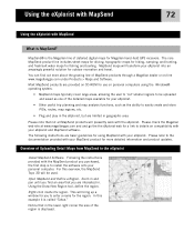
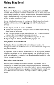
... the user to 'cut' smaller regions to install the software onto your personal computer. Following the instructions provided with your eXplorist. The core MapSend product line includes street maps for driving, topographic maps for hiking, camping, and hunting, and fresh/salt water maps for... inside the region. Notice that not all MapSend products will bring up a window for Magellan hand-held GPS receivers. MapSend® is the Magellan line of the detailed maps available for your eXplorist. • Other useful trip planning and map analysis functions, such as one of detailed...
... the user to 'cut' smaller regions to install the software onto your personal computer. Following the instructions provided with your eXplorist. The core MapSend product line includes street maps for driving, topographic maps for hiking, camping, and hunting, and fresh/salt water maps for... inside the region. Notice that not all MapSend products will bring up a window for Magellan hand-held GPS receivers. MapSend® is the Magellan line of the detailed maps available for your eXplorist. • Other useful trip planning and map analysis functions, such as one of detailed...

Manual - English
Page 78
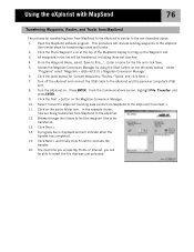
..., Routes, and Track Between MapSend and eXplorist You can be transferred. 10. Access the Magellan Conversion Manager by using the Magellan Conversion Manager. Click on the Magellan Conversion Manager. 7. Click Next >. 11. Since the eXplorist stores these data items in a more accessible manner than previous GPS receivers, you converted. Under "Programs" select 'Magellan > eXplorist 210 > Magellan Conversion Manager'. 3. Click the radio...
..., Routes, and Track Between MapSend and eXplorist You can be transferred. 10. Access the Magellan Conversion Manager by using the Magellan Conversion Manager. Click on the Magellan Conversion Manager. 7. Click Next >. 11. Since the eXplorist stores these data items in a more accessible manner than previous GPS receivers, you converted. Under "Programs" select 'Magellan > eXplorist 210 > Magellan Conversion Manager'. 3. Click the radio...
Manual - English
Page 79
..., Routes, and Tracks from MapSend The process for transferring from from MapSend to the eXplorist) Click Next >. 11. Under "Programs" select 'Magellan > eXplorist 210 > Magellan Conversion Manager'. 6. Turn the eXplorist on the Windows toolbar. In the example shown, files are being transferred from MapSend...Click Next > and finally click Finish to the eXplorist. 12. All waypoints in the list will be transferred, including those not checked. 4. Access the Magellan Conversion Manager by using the Start button on . Open the MapSend software program. From the Waypoint Menu, select 'Save...
..., Routes, and Tracks from MapSend The process for transferring from from MapSend to the eXplorist) Click Next >. 11. Under "Programs" select 'Magellan > eXplorist 210 > Magellan Conversion Manager'. 6. Turn the eXplorist on the Windows toolbar. In the example shown, files are being transferred from MapSend...Click Next > and finally click Finish to the eXplorist. 12. All waypoints in the list will be transferred, including those not checked. 4. Access the Magellan Conversion Manager by using the Start button on . Open the MapSend software program. From the Waypoint Menu, select 'Save...
Manual - English
Page 84
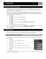
... joystick to not use or do not have the option of Measure The eXplorist can use MapSend Worldwide software (purchased separately) to highlight the desired map. If you can be used by the eXplorist. Use the Arrow joystick to define your eXplorist. Note: If you select Detail Map, you may use one . Preferences 81...
... joystick to not use or do not have the option of Measure The eXplorist can use MapSend Worldwide software (purchased separately) to highlight the desired map. If you can be used by the eXplorist. Use the Arrow joystick to define your eXplorist. Note: If you select Detail Map, you may use one . Preferences 81...
User Manual
Page 1
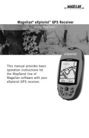
Magellan® eXplorist™ GPS Receiver Using MapSend™ This manual provides basic operation instructions for the MapSend line of Magellan software with your eXplorist GPS receiver.
Magellan® eXplorist™ GPS Receiver Using MapSend™ This manual provides basic operation instructions for the MapSend line of Magellan software with your eXplorist GPS receiver.
User Manual
Page 3
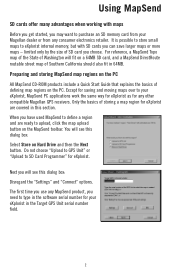
... driving, topographic maps for hiking, camping, and hunting, and fresh and salt water maps for Magellan hand-held GPS receivers. MapSend is MapSend? If you MUST first save the map region on SD cards. • Plug and play in the eXplorist, but are limited in the eXplorist. You can handle large ... utilized makes it to an SD card (either by using the MapSend software, and then transfer it easier to eXplorist, and easily switch maps on the eXplorist as pre-loaded map regions on your eXplorist into the receiver, mostly because of map data that could be uploaded into an amazingly...
... driving, topographic maps for hiking, camping, and hunting, and fresh and salt water maps for Magellan hand-held GPS receivers. MapSend is MapSend? If you MUST first save the map region on SD cards. • Plug and play in the eXplorist, but are limited in the eXplorist. You can handle large ... utilized makes it to an SD card (either by using the MapSend software, and then transfer it easier to eXplorist, and easily switch maps on the eXplorist as pre-loaded map regions on your eXplorist into the receiver, mostly because of map data that could be uploaded into an amazingly...
User Manual
Page 4
... to purchase an SD memory card from your Magellan dealer or from any other compatible Magellan GPS receivers. Only the basics of storing a map region for your eXplorist in this section. The first time you use any MapSend product, you need to type in the software serial number for eXplorist are ready to SD Card Programmer" for...
... to purchase an SD memory card from your Magellan dealer or from any other compatible Magellan GPS receivers. Only the basics of storing a map region for your eXplorist in this section. The first time you use any MapSend product, you need to type in the software serial number for eXplorist are ready to SD Card Programmer" for...
User Manual
Page 6
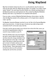
... the storage destination from the drop down list on the right. Please allow plenty of this screen, you wish to copy to be compatible with eXplorist. Click the checkbox next to any .imi files in the list box on the MapSend product you 've chosen to create .mgi files. At the... lower right of time for the software patch v.1.30 or higher that produces .img files, check the Magellan website for the file to write to start the map transfer. For example, if you made a region named "Rockies", the...
... the storage destination from the drop down list on the right. Please allow plenty of this screen, you wish to copy to be compatible with eXplorist. Click the checkbox next to any .imi files in the list box on the MapSend product you 've chosen to create .mgi files. At the... lower right of time for the software patch v.1.30 or higher that produces .img files, check the Magellan website for the file to write to start the map transfer. For example, if you made a region named "Rockies", the...
