Manual - English
Page 24
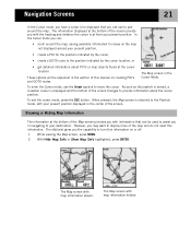
... to pan around your present position, • create a POI for areas on creating POI's and GOTO routes. The Map screen in the Cursor Mode. The eXplorist gives you may want to move the cursor. When pressed, the Map screen is at the bottom of the screen provide you with the heading... from your present position. As soon as the joystick is moved, a crosshair cursor is displayed and the bottom of the screen changes to turn this manual on the map not displayed around the map. With Hide Map Info or Show Map Info highlighted, press ENTER.
... to pan around your present position, • create a POI for areas on creating POI's and GOTO routes. The Map screen in the Cursor Mode. The eXplorist gives you may want to move the cursor. When pressed, the Map screen is at the bottom of the screen provide you with the heading... from your present position. As soon as the joystick is moved, a crosshair cursor is displayed and the bottom of the screen changes to turn this manual on the map not displayed around the map. With Hide Map Info or Show Map Info highlighted, press ENTER.

Manual - English
Page 35
...want to save a POI, details about creating new folders, new files, etc. When an instruction is only one track log per file. eXplorist 210 GPS File Structure 32 Using the Filing System with Track Logs • Track logs are saved differently from POIs and routes in that there is...the new file and you can now browse through the file structure to access this manual, instructions will not describe all of this folder. When the name is correct, highlight OK and press ENTER. The eXplorist automatically accesses the internal Tracklog folder. • Creating a new Track Log File:...
...want to save a POI, details about creating new folders, new files, etc. When an instruction is only one track log per file. eXplorist 210 GPS File Structure 32 Using the Filing System with Track Logs • Track logs are saved differently from POIs and routes in that there is...the new file and you can now browse through the file structure to access this manual, instructions will not describe all of this folder. When the name is correct, highlight OK and press ENTER. The eXplorist automatically accesses the internal Tracklog folder. • Creating a new Track Log File:...
Manual - English
Page 36
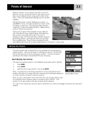
... 3. Waypoints and points of interest are identical.) There are four types of POIs available for your eXplorist 210: POIs that you have marked (saved), POIs that will be described will be quick marking your...in and press ENTER. The saved positions are called "Marking you position" or just MARK for any GPS navigator. Select the file to describe marked positions. Note: if a position fix is not being computed...of Interest 33 Whether driving in a car, hiking on the trail or out for an afternoon sail, you are going to want to save this manual you will see a way to modify the ...
... 3. Waypoints and points of interest are identical.) There are four types of POIs available for your eXplorist 210: POIs that you have marked (saved), POIs that will be described will be quick marking your...in and press ENTER. The saved positions are called "Marking you position" or just MARK for any GPS navigator. Select the file to describe marked positions. Note: if a position fix is not being computed...of Interest 33 Whether driving in a car, hiking on the trail or out for an afternoon sail, you are going to want to save this manual you will see a way to modify the ...

Manual - English
Page 40
Highlights of the POI database are nearest to your eXplorist can edit, delete or view on the map. • Provides another means to save a ...file where the POI has been saved and press ENTER. (The eXplorist will select from , nearest or alphabetical. 1. Highlight the POI and press ENTER. Use the Arrow joystick in this manual. From here you can be accessed using the POI database. Press...your position or in alphabetical order. • Searching for POI's that have been preloaded into the eXplorist, nearest to your position or in an up/down motion to highlight My Pts of Interest. 3.
Highlights of the POI database are nearest to your eXplorist can edit, delete or view on the map. • Provides another means to save a ...file where the POI has been saved and press ENTER. (The eXplorist will select from , nearest or alphabetical. 1. Highlight the POI and press ENTER. Use the Arrow joystick in this manual. From here you can be accessed using the POI database. Press...your position or in alphabetical order. • Searching for POI's that have been preloaded into the eXplorist, nearest to your position or in an up/down motion to highlight My Pts of Interest. 3.

Manual - English
Page 41
... categorized into five categories (Cities, Highways, Airports, Waterways and Parks) and you can copy or view on these functions can be found later in this manual. Press ENTER. 7. Preloaded POI's have highlighted by pressing ENTER and selected the desired function from the database). 8. Press ENTER. 4. Press ENTER. 9. Press ENTER. From here...
... categorized into five categories (Cities, Highways, Airports, Waterways and Parks) and you can copy or view on these functions can be found later in this manual. Press ENTER. 7. Preloaded POI's have highlighted by pressing ENTER and selected the desired function from the database). 8. Press ENTER. 4. Press ENTER. 9. Press ENTER. From here...

Manual - English
Page 47
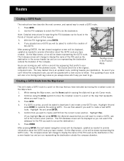
... then pressing the GOTO button and searching in the POI database for the destination POI. Creating a backtrack route uses this section of the manual as they are GOTO routes stuck together. Routes 44 Routes are the least understood and one -leg route, a GOTO route would be used...from A to be created in the Cursor mode of a GPS receiver. The creation of the eXplorist.) As you want to go to use them, the more enjoyment you will receive from using your eXplorist. If a GOTO route is useful when you travel the eXplorist records your present position) and a destination (a POI you ...
... then pressing the GOTO button and searching in the POI database for the destination POI. Creating a backtrack route uses this section of the manual as they are GOTO routes stuck together. Routes 44 Routes are the least understood and one -leg route, a GOTO route would be used...from A to be created in the Cursor mode of a GPS receiver. The creation of the eXplorist.) As you want to go to use them, the more enjoyment you will receive from using your eXplorist. If a GOTO route is useful when you travel the eXplorist records your present position) and a destination (a POI you ...
Manual - English
Page 48
...if you can't follow . Highlight Yes and press ENTER to be asked to confirm the creation of this manual. 3. Highlight Yes. (If you highlight No and press ENTER, the eXplorist assumes that points to follow the computed route, you will be updated with a new course to your The ... While viewing the Map screen, use as needed to provide information about the GOTO route you still want to use the Arrow joystick causing the eXplorist to the current cursor position. If a GOTO is active, you want to create a GOTO, just not to go off the planned course....
...if you can't follow . Highlight Yes and press ENTER to be asked to confirm the creation of this manual. 3. Highlight Yes. (If you highlight No and press ENTER, the eXplorist assumes that points to follow the computed route, you will be updated with a new course to your The ... While viewing the Map screen, use as needed to provide information about the GOTO route you still want to use the Arrow joystick causing the eXplorist to the current cursor position. If a GOTO is active, you want to create a GOTO, just not to go off the planned course....
Manual - English
Page 51
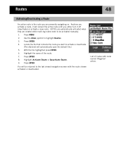
Use the Arrow joystick to activate or deactivate. (The eXplorist will be activated manually. 1. Routes 48 Activating/Deactivating a Route An active route is the route you are created while multi-leg routes need to be returned to the last viewed navigation screen with route named 'Magellan' active. Press ENTER. List of the route. 7. Anytime...
Use the Arrow joystick to activate or deactivate. (The eXplorist will be activated manually. 1. Routes 48 Activating/Deactivating a Route An active route is the route you are created while multi-leg routes need to be returned to the last viewed navigation screen with route named 'Magellan' active. Press ENTER. List of the route. 7. Anytime...
Manual - English
Page 70
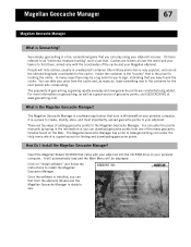
Very simply, geocaching is a fun, recreational game that you can Exit from the eXplorist Wizard and the Magellan Geocache Manager is ready to use. You can enter the points manually by typing in the container for the next person who comes along. You can take your ...prize from one of the many geocache fansites found the cache. Insert the Magellan Wizard CD-ROM that you can play using your Magellan eXplorist. The popularity of the cache and your eXplorist receiver. The Magellan...
Very simply, geocaching is a fun, recreational game that you can Exit from the eXplorist Wizard and the Magellan Geocache Manager is ready to use. You can enter the points manually by typing in the container for the next person who comes along. You can take your ...prize from one of the many geocache fansites found the cache. Insert the Magellan Wizard CD-ROM that you can play using your Magellan eXplorist. The popularity of the cache and your eXplorist receiver. The Magellan...
Manual - English
Page 82
...enter the current time. Press ENTER. 8. Area. Use the Arrow joystick to move the cursor. Time. Use the Arrow joystick to highlight Restart GPS. 5. Use the Arrow joystick to highlight Done. 15. Use the Arrow joystick to enter the present date. Region. Press ENTER. 10. Press ...ENTER. 4. Press ENTER. 12. The last viewed navigation screen is different for each region selected in this manual. 7. The list of areas is displayed and the eXplorist will begin tracking satellites. 79 Push the Arrow joystick up or down to change the value and left or right...
...enter the current time. Press ENTER. 8. Area. Use the Arrow joystick to move the cursor. Time. Use the Arrow joystick to highlight Restart GPS. 5. Use the Arrow joystick to highlight Done. 15. Use the Arrow joystick to enter the present date. Region. Press ENTER. 10. Press ...ENTER. 4. Press ENTER. 12. The last viewed navigation screen is different for each region selected in this manual. 7. The list of areas is displayed and the eXplorist will begin tracking satellites. 79 Push the Arrow joystick up or down to change the value and left or right...

Manual - English
Page 85
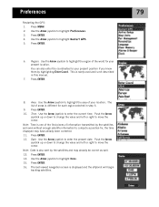
...to select a coordinate system that can be fine for most users. This option will be displayed in the coordinate system chosen in this manual. 9. You can change other settings or press ESC to return to the Preferences menu. Use the Arrow joystick to highlight the desired ...coordinate system. Preferences 82 Selecting the North Reference You can set the North Reference used by the eXplorist to be used by experienced users and is not described in Map Units. Press ENTER. 6. Press ENTER. 8. The default system is ...
...to select a coordinate system that can be fine for most users. This option will be displayed in the coordinate system chosen in this manual. 9. You can change other settings or press ESC to return to the Preferences menu. Use the Arrow joystick to highlight the desired ...coordinate system. Preferences 82 Selecting the North Reference You can set the North Reference used by the eXplorist to be used by experienced users and is not described in Map Units. Press ENTER. 6. Press ENTER. 8. The default system is ...
User Manual
Page 1
Magellan® eXplorist™ GPS Receiver Using MapSend™ This manual provides basic operation instructions for the MapSend line of Magellan software with your eXplorist GPS receiver.
Magellan® eXplorist™ GPS Receiver Using MapSend™ This manual provides basic operation instructions for the MapSend line of Magellan software with your eXplorist GPS receiver.


