Getting Started Guide
Page 2
...to the following two conditions: (1) this device may not cause interference, and (2) this device must accept any change in the GPS. (Note: Magellan Navigation GPS receivers use ; (ii) disasters such as UPS or FedEx when returning a product for a period of 30 days from the ... conform to the then-current user documentation provided with no guarantee that software products or software included in hardware products will conform to you. The following measures: • Reorient or relocate the receiving antenna. • Increase the separation between the antenna of the device...
...to the following two conditions: (1) this device may not cause interference, and (2) this device must accept any change in the GPS. (Note: Magellan Navigation GPS receivers use ; (ii) disasters such as UPS or FedEx when returning a product for a period of 30 days from the ... conform to the then-current user documentation provided with no guarantee that software products or software included in hardware products will conform to you. The following measures: • Reorient or relocate the receiving antenna. • Increase the separation between the antenna of the device...
Getting Started Guide
Page 3
... can occur due to changes in the GPS. (Note: Magellan Navigation GPS receivers use GPS or GPS+GLONASS to the then-current user documentation provided with the software (including updates thereto). For further information concerning this warranty. Magellan Professional Products Limited Warranty (Europe, Middle East, Africa) All Magellan Navigation global positioning system (GPS) receivers are navigation aids, and are excluded from...
... can occur due to changes in the GPS. (Note: Magellan Navigation GPS receivers use GPS or GPS+GLONASS to the then-current user documentation provided with the software (including updates thereto). For further information concerning this warranty. Magellan Professional Products Limited Warranty (Europe, Middle East, Africa) All Magellan Navigation global positioning system (GPS) receivers are navigation aids, and are excluded from...
Getting Started Guide
Page 5
...Features 1 Software Provided as Standard 2 Optional Software 2 About Windows CE 2 Receiver Description 3 Front Panel 3 Back Panel 3 Side Panel 4 I/O Module 4 Setting the Mini-USB Port (I/O Module 5 Resetting MobileMapper CX 5 Preparing for First-Time Use 6 Charging the battery 6 Turning the Receiver On ...GPS Receiver to your Application ..... 17 Step-by-Step Procedure for Establishing a GPRS Connection Via Bluetooth 18 Introduction 18 Connection Profile Known 18 Connection Profile Unknown 19 Special Cases 19 The First Time You Use MobileMapper CX 20 Step1: Ask MobileMapper CX...
...Features 1 Software Provided as Standard 2 Optional Software 2 About Windows CE 2 Receiver Description 3 Front Panel 3 Back Panel 3 Side Panel 4 I/O Module 4 Setting the Mini-USB Port (I/O Module 5 Resetting MobileMapper CX 5 Preparing for First-Time Use 6 Charging the battery 6 Turning the Receiver On ...GPS Receiver to your Application ..... 17 Step-by-Step Procedure for Establishing a GPRS Connection Via Bluetooth 18 Introduction 18 Connection Profile Known 18 Connection Profile Unknown 19 Special Cases 19 The First Time You Use MobileMapper CX 20 Step1: Ask MobileMapper CX...
Getting Started Guide
Page 9
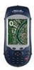
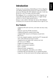
... 320 x 240 resolution and touch screen. - SD card up to choose the GIS software that is a handheld device that integrates submeter GPS with Microsoft Windows CE in your Windows CE GPS handheld computer. Support for purchasing a MobileMapper CX from Magellan. Integrated Bluetooth wireless technology. - Embedded Microsoft Windows CE 5.0 operating system. - English Introduction Thank you to 4 GBytes...
... 320 x 240 resolution and touch screen. - SD card up to choose the GIS software that is a handheld device that integrates submeter GPS with Microsoft Windows CE in your Windows CE GPS handheld computer. Support for purchasing a MobileMapper CX from Magellan. Integrated Bluetooth wireless technology. - Embedded Microsoft Windows CE 5.0 operating system. - English Introduction Thank you to 4 GBytes...
Getting Started Guide
Page 10
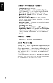
... touch screen. 2 Magellan GIS application (Mobile Mapping). Software for small devices such as Standard - Microsoft File Viewers, including Docviewer, Pdfviewer, Presviewer and XLS. - Magellan GPS utilities, including DGPS Configuration, GPS Initialization, GPS Port Configurations, GPS Reset, GPS Settings, GPS Status and Mission Planning. - Optional Software - Communication tool (Terminal) - About Windows CE Windows CE is embedded with the MobileMapper CX, use the stylus...
... touch screen. 2 Magellan GIS application (Mobile Mapping). Software for small devices such as Standard - Microsoft File Viewers, including Docviewer, Pdfviewer, Presviewer and XLS. - Magellan GPS utilities, including DGPS Configuration, GPS Initialization, GPS Port Configurations, GPS Reset, GPS Settings, GPS Status and Mission Planning. - Optional Software - Communication tool (Terminal) - About Windows CE Windows CE is embedded with the MobileMapper CX, use the stylus...
Getting Started Guide
Page 18
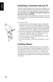
...) on the I/O module (see opposite). 3. Connect the USB data cable to establish a connection. Magellan recommends you install your MobileMapper CX handheld via the USB data cable. You may install any supported software you need. Connect the other end of ActiveSync. Installing Software Once the connection is very important to make sure you always use the...
...) on the I/O module (see opposite). 3. Connect the USB data cable to establish a connection. Magellan recommends you install your MobileMapper CX handheld via the USB data cable. You may install any supported software you need. Connect the other end of ActiveSync. Installing Software Once the connection is very important to make sure you always use the...
Getting Started Guide
Page 25
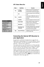
... the current software version of the GPS Status utility. When checked, this command to be created before starting logging data. Function Allows you just have to off-the-shelf Windows CE mobile mapping applications running on the Stats tab (see page 46). 17 Connecting the Internal GPS Receiver to set the... units used for calculating the averaged positions displayed on MobileMapper CX. Stops data logging and closes the log file.
... the current software version of the GPS Status utility. When checked, this command to be created before starting logging data. Function Allows you just have to off-the-shelf Windows CE mobile mapping applications running on the Stats tab (see page 46). 17 Connecting the Internal GPS Receiver to set the... units used for calculating the averaged positions displayed on MobileMapper CX. Stops data logging and closes the log file.
Getting Started Guide
Page 56
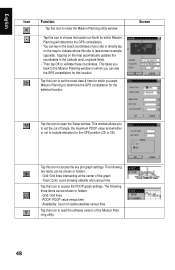
... for this site is (see the GPS constellation for the selected location. This window allows you to set the exact date & time for which you can key in the Latitude and Longitude fields. - Tap this icon to read the software version of your site or directly tap on the map ...items can be shown or hidden: - Availability: Count of the graph - Then tap OK to choose the location on which Mission Planning will determine the GPS constellation. - Tap this icon to access the sky plot graph settings. Screen Tap this icon to close the Mission Planning utility window. - PDOP: PDOP...
... for this site is (see the GPS constellation for the selected location. This window allows you to set the exact date & time for which you can key in the Latitude and Longitude fields. - Tap this icon to read the software version of your site or directly tap on the map ...items can be shown or hidden: - Availability: Count of the graph - Then tap OK to choose the location on which Mission Planning will determine the GPS constellation. - Tap this icon to access the sky plot graph settings. Screen Tap this icon to close the Mission Planning utility window. - PDOP: PDOP...
Getting Started Guide
Page 82
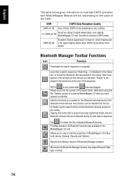
English The table below gives indications on how safe DGPS operation with MobileMapper Beacon will be, depending on the value of the SNR. SNR DGPS Data Reception Quality SNR
English The table below gives indications on how safe DGPS operation with MobileMapper Beacon will be, depending on the value of the SNR. SNR DGPS Data Reception Quality SNR
