
Quick Reference Guide
Page 2
... usable on SD cards (MapSend Topo Mexico, Topo France, etc.) ° MapSend BlueNav Charts ° MapSend Lakes USA products ° Detailed MapSend maps that include view, manage and add/edit geocaches as well as waypoints, tracks, routes and geocaches. • Give access to utilities to convert user data between a PC and Magellan Meridian and SporTrak GPS receivers.) • Provide...
... usable on SD cards (MapSend Topo Mexico, Topo France, etc.) ° MapSend BlueNav Charts ° MapSend Lakes USA products ° Detailed MapSend maps that include view, manage and add/edit geocaches as well as waypoints, tracks, routes and geocaches. • Give access to utilities to convert user data between a PC and Magellan Meridian and SporTrak GPS receivers.) • Provide...
Quick Reference Guide
Page 4
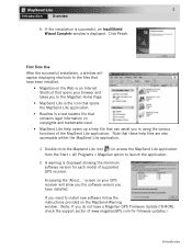
... the Start > All Programs > Magellan option to install new software follow the instructions provided on the MapSend-Warning window. (Note: If you in using the various functions of the MapSend Lite application. 3 Introduction Overview 6. screen on the Web is an Internet Shortcut that opens your GPS receiver will show you the software version you need to...
... the Start > All Programs > Magellan option to install new software follow the instructions provided on the MapSend-Warning window. (Note: If you in using the various functions of the MapSend Lite application. 3 Introduction Overview 6. screen on the Web is an Internet Shortcut that opens your GPS receiver will show you the software version you need to...
Quick Reference Guide
Page 10
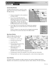
... Window The search options available are highly improved over previous software applications. 8 Introduction Overview Overview Map Window The Map Overview window is chosen, the view scale will be dragged by the mouse, and the map in the Map Window will re-center to -point" routes • ... routes, tracks and geocaches. MapSend Lite includes four unique search options: Smart, Address, POI and Coordinate. Overview Map Viewer Window Within the Map window, you right-click on the Map Overview window, both the box and the contents of the Map window will move accordingly. •...
... Window The search options available are highly improved over previous software applications. 8 Introduction Overview Overview Map Window The Map Overview window is chosen, the view scale will be dragged by the mouse, and the map in the Map Window will re-center to -point" routes • ... routes, tracks and geocaches. MapSend Lite includes four unique search options: Smart, Address, POI and Coordinate. Overview Map Viewer Window Within the Map window, you right-click on the Map Overview window, both the box and the contents of the Map window will move accordingly. •...

Quick Reference Guide
Page 1
... view fully detailed street maps for any USA city and airport, along with many parks, lakes, streams, rivers, and dams. MapSend contains a wide assortment of each leg and the total distance to upload, download and customize data for route management. MapSend™ Series Software Quick Reference Guide Introduction: Magellan's MapSend™ Streets Gold and MapSend™ Topo of the...
... view fully detailed street maps for any USA city and airport, along with many parks, lakes, streams, rivers, and dams. MapSend contains a wide assortment of each leg and the total distance to upload, download and customize data for route management. MapSend™ Series Software Quick Reference Guide Introduction: Magellan's MapSend™ Streets Gold and MapSend™ Topo of the...
Quick Reference Guide
Page 2
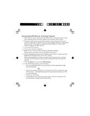
Make sure you have correctly installed the MapSend software. (Please refer to let the program find the appropriate COM port and baud rate. In the GPS Settings dialog, do the following: • Click the Autodetect button to the back cover for installation instructions.) 6. Using the captive ... with the DIN-9 connector to an available COM port. From the Options menu choose GPS Settings... 8. Remember which your personal computer and connect the other end of the receiver. 2. When starting MapSend , please note that which port you are using as you will need this information ...
Make sure you have correctly installed the MapSend software. (Please refer to let the program find the appropriate COM port and baud rate. In the GPS Settings dialog, do the following: • Click the Autodetect button to the back cover for installation instructions.) 6. Using the captive ... with the DIN-9 connector to an available COM port. From the Options menu choose GPS Settings... 8. Remember which your personal computer and connect the other end of the receiver. 2. When starting MapSend , please note that which port you are using as you will need this information ...

Quick Reference Guide
Page 6
...size of the United States software.) - Refer to the User Manual on the "T" or "P" will be uploaded. After selecting (marking) a region, you need to make sure your PC has been properly connected to the GPS receiver and the required ...communication options have been converted. Along with the check box for Topographic is available only with the MapSend Topo of the regions you want to be uploaded ...regions by editing the region rectangles and referring to upload the POI's and Topo map (if available). -
...size of the United States software.) - Refer to the User Manual on the "T" or "P" will be uploaded. After selecting (marking) a region, you need to make sure your PC has been properly connected to the GPS receiver and the required ...communication options have been converted. Along with the check box for Topographic is available only with the MapSend Topo of the regions you want to be uploaded ...regions by editing the region rectangles and referring to upload the POI's and Topo map (if available). -