Automotive Owner's Manual
Page 2
...U.S. microSD™ is a trademark of SanDisk or is under license. © 2009 Garmin Ltd. or its subsidiaries. myGarmin™, aera™, ecoRoute™, Garmin Lock™, and nüMaps Guarantee™ are trademarks of Apple Computer, Inc., ...XM Satellite Radio Inc. and other countries. Garmin hereby grants permission to download a single copy of Garmin. These trademarks may be used without the express prior written consent of this manual onto a hard drive or other Garmin products. Audible.com® is strictly prohibited. XM Radio and XM WX™ Weather...
...U.S. microSD™ is a trademark of SanDisk or is under license. © 2009 Garmin Ltd. or its subsidiaries. myGarmin™, aera™, ecoRoute™, Garmin Lock™, and nüMaps Guarantee™ are trademarks of Apple Computer, Inc., ...XM Satellite Radio Inc. and other countries. Garmin hereby grants permission to download a single copy of Garmin. These trademarks may be used without the express prior written consent of this manual onto a hard drive or other Garmin products. Audible.com® is strictly prohibited. XM Radio and XM WX™ Weather...
Automotive Owner's Manual
Page 4
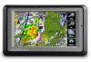
... Unit Converter 27 aera 500 Series Owner's Manual Introduction Table of Contents Introduction i Manual Conventions i aera Tips and Shortcuts i Contact Garmin i myGarmin i aera 500 Series Models iv Getting Started 1 Installing the Battery 2 Charging Your aera 2 Mounting Your aera in Your Area ...Audible Books 21 Managing Files 22 Supported File Types 22 Connecting Your aera to XM Radio 16 Weather 17 Using FM TMC Traffic 18 Receiving Traffic Information 18 Traffic in an Automobile.......2 Configuring Your aera 3 Acquiring Satellites 3 Changing Modes 3 Using the Menu Page ...
... Unit Converter 27 aera 500 Series Owner's Manual Introduction Table of Contents Introduction i Manual Conventions i aera Tips and Shortcuts i Contact Garmin i myGarmin i aera 500 Series Models iv Getting Started 1 Installing the Battery 2 Charging Your aera 2 Mounting Your aera in Your Area ...Audible Books 21 Managing Files 22 Supported File Types 22 Connecting Your aera to XM Radio 16 Weather 17 Using FM TMC Traffic 18 Receiving Traffic Information 18 Traffic in an Automobile.......2 Configuring Your aera 3 Acquiring Satellites 3 Changing Modes 3 Using the Menu Page ...
Automotive Owner's Manual
Page 22
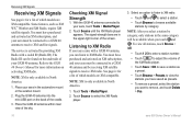
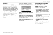
... 40 Owner's Manual for a list of which models are in North America. 1. Listening to XM Radio If your aera must be available when you have purchased and activated an XM subscription, and your aera came with a coded ID (Radio ID). NOTE: After you select a station by category, ...and be found on the back of your aera in North America. 1. Receiving XM Signals Receiving XM Signals See page iv for a list of the XM Radio player. • Touch Save > OK to save a station as XM WX™ Weather and XM Radio, require XM satellite signals. The service is activated by ...
... 40 Owner's Manual for a list of which models are in North America. 1. Listening to XM Radio If your aera must be available when you have purchased and activated an XM subscription, and your aera came with a coded ID (Radio ID). NOTE: After you select a station by category, ...and be found on the back of your aera in North America. 1. Receiving XM Signals Receiving XM Signals See page iv for a list of the XM Radio player. • Touch Save > OK to save a station as XM WX™ Weather and XM Radio, require XM satellite signals. The service is activated by ...
Automotive Owner's Manual
Page 23
.... • Lightning-shows recent lightning strikes. Receiving XM Signals Viewing Weather on all aera models. XM is only available in ascending order by distance. 3-Day-view an extended forecast for a list of current weather patterns. NOTE: XM is not available on the Map Touch Tools > Weather > Map. Touch Tools > Weather. The weather forecast for another location. Other City-view...
.... • Lightning-shows recent lightning strikes. Receiving XM Signals Viewing Weather on all aera models. XM is only available in ascending order by distance. 3-Day-view an extended forecast for a list of current weather patterns. NOTE: XM is not available on the Map Touch Tools > Weather > Map. Touch Tools > Weather. The weather forecast for another location. Other City-view...

Automotive Owner's Manual
Page 36
... 40 antenna is required to view weather information on the map. Map Info-view the maps loaded on or off. NOTE: An XM signal is attached. Garmin Lock-turn safe mode on your trip log, touch Tools > My Data > Clear Trip Log. Customizing the aera Changing the Map Settings Touch Tools... > Settings > Map. Map Detail-adjust the amount of your aera. Trip Log-show or hide weather conditions on the map....
... 40 antenna is required to view weather information on the map. Map Info-view the maps loaded on or off. NOTE: An XM signal is attached. Garmin Lock-turn safe mode on your trip log, touch Tools > My Data > Clear Trip Log. Customizing the aera Changing the Map Settings Touch Tools... > Settings > Map. Map Detail-adjust the amount of your aera. Trip Log-show or hide weather conditions on the map....
Automotive Quick Start Manual
Page 5
...560 models. Receiving XM® Satellite Signals XM is only available on the underside of the map. For more information on XM subscriptions, go to the GXM 40 Owner's Manual for more information on the map, and directions at the top of your aera recalculates the route and provides new directions. Refer to www.garmin.com/xm...Your Route Your route is activated by providing XM Radio with a coded ID (Radio ID). A speed limit icon could appear as XM WX™ Weather and XM Radio, require XM satellite signals. As you travel, your aera guides you travel on major roadways. ➋...
...560 models. Receiving XM® Satellite Signals XM is only available on the underside of the map. For more information on XM subscriptions, go to the GXM 40 Owner's Manual for more information on the map, and directions at the top of your aera recalculates the route and provides new directions. Refer to www.garmin.com/xm...Your Route Your route is activated by providing XM Radio with a coded ID (Radio ID). A speed limit icon could appear as XM WX™ Weather and XM Radio, require XM satellite signals. As you travel, your aera guides you travel on major roadways. ➋...
Automotive Quick Start Manual
Page 8
... be used without the express permission of your Garmin products, visit the Garmin Web site at www.garmin.com. Other trademarks and trade names are trademarks of XM Satellite Radio Inc. XM Radio and XM WX™ Weather are those of their respective owners. For the...Garmin Ltd. or its subsidiaries. Garmin® and the Garmin logo are trademarks of XM Satellite Radio Inc. B Printed in the USA and other countries. The Bluetooth® word mark and logos are trademarks of such name by the Bluetooth SIG, Inc., and any use of Garmin Ltd. nüMaps Guarantee™ and aera...
... be used without the express permission of your Garmin products, visit the Garmin Web site at www.garmin.com. Other trademarks and trade names are trademarks of XM Satellite Radio Inc. XM Radio and XM WX™ Weather are those of their respective owners. For the...Garmin Ltd. or its subsidiaries. Garmin® and the Garmin logo are trademarks of XM Satellite Radio Inc. B Printed in the USA and other countries. The Bluetooth® word mark and logos are trademarks of such name by the Bluetooth SIG, Inc., and any use of Garmin Ltd. nüMaps Guarantee™ and aera...
Aviation Quick Reference Guide
Page 6
A Table of Contents Section 4 Hazard Avoidance 27 4.1 XM® Weather (aera 510 & 560 27 4.2 Terrain...27 4.3 Traffic Information Service (TIS 28 Section 5 Utilities 29 5.1 Flight Log...29 5.2 Track Log...29 5.3 E6B Calculator...30 5.4 Aircraft Profile...31 5.5 Weight & Balance...32 Section 6 Appendix 33 Miscellaneous Message Advisories 33 Airspace Messages...34 Data Field & Numeric Data Options 35 Aural Alerts...37 Loss of GPS Position...37 Hazard Display with Loss of GPS Position 37 ii Garmin aera 500 Series Quick Reference Guide 190-01117-03 Rev.
A Table of Contents Section 4 Hazard Avoidance 27 4.1 XM® Weather (aera 510 & 560 27 4.2 Terrain...27 4.3 Traffic Information Service (TIS 28 Section 5 Utilities 29 5.1 Flight Log...29 5.2 Track Log...29 5.3 E6B Calculator...30 5.4 Aircraft Profile...31 5.5 Weight & Balance...32 Section 6 Appendix 33 Miscellaneous Message Advisories 33 Airspace Messages...34 Data Field & Numeric Data Options 35 Aural Alerts...37 Loss of GPS Position...37 Hazard Display with Loss of GPS Position 37 ii Garmin aera 500 Series Quick Reference Guide 190-01117-03 Rev.
Aviation Quick Reference Guide
Page 33
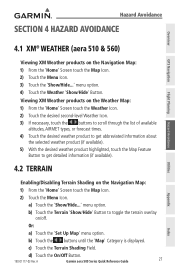
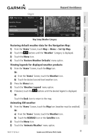
... Garmin aera 500 Series Quick Reference Guide 27 Utilities Appendix Index c) Touch the Terrain Shading Field. menu option. a) Touch the 'Show/Hide...' Or: a) Touch the 'Set Up Map' menu option. Viewing XM Weather products on the Weather Map: 1) From the 'Home' Screen touch the Weather ...' Screen touch the Map Icon. 2) Touch the Menu Icon. menu option. 4) Touch the Weather 'Show/Hide' Button. Hazard Avoidance Section 4 Hazard Avoidance Overview GPS Navigation Flight Planning Hazard Avoidance 4.1 XM® Weather (aera 510 & 560) Viewing XM Weather products on /off.
... Garmin aera 500 Series Quick Reference Guide 27 Utilities Appendix Index c) Touch the Terrain Shading Field. menu option. a) Touch the 'Show/Hide...' Or: a) Touch the 'Set Up Map' menu option. Viewing XM Weather products on the Weather Map: 1) From the 'Home' Screen touch the Weather ...' Screen touch the Map Icon. 2) Touch the Menu Icon. menu option. 4) Touch the Weather 'Show/Hide' Button. Hazard Avoidance Section 4 Hazard Avoidance Overview GPS Navigation Flight Planning Hazard Avoidance 4.1 XM® Weather (aera 510 & 560) Viewing XM Weather products on /off.
Aviation Quick Reference Guide
Page 46
A Index Appendix Utilities Hazard Avoidance Flight Planning GPS Navigation Overview Index Weather 12 Overlays Displaying/removing 12 P Panel 14 R Red X 37 Runways 16 S Scrolling 9 T Terrain 27 Tools 7 Track Log 29 Traffic Information Service (TIS) 28 Symbology 28 U User Waypoints Creating 18 V Vectors-to-Final 26 Vertical Navigation (VNAV) 15 Profile 15 W Waypoints 16 Weather 17 Weight & Balance 32 X XM Weather 27, 29, 30, 31, 32 Index-2 Garmin aera 500 Series Quick Reference Guide 190-01117-03 Rev.
A Index Appendix Utilities Hazard Avoidance Flight Planning GPS Navigation Overview Index Weather 12 Overlays Displaying/removing 12 P Panel 14 R Red X 37 Runways 16 S Scrolling 9 T Terrain 27 Tools 7 Track Log 29 Traffic Information Service (TIS) 28 Symbology 28 U User Waypoints Creating 18 V Vectors-to-Final 26 Vertical Navigation (VNAV) 15 Profile 15 W Waypoints 16 Weather 17 Weight & Balance 32 X XM Weather 27, 29, 30, 31, 32 Index-2 Garmin aera 500 Series Quick Reference Guide 190-01117-03 Rev.
Pilot's Guide
Page 6
...aera GPS receivers is obtained from the altitude displayed by the aircraft altimeter when determining or selecting aircraft altitude. WARNING: Navigation and terrain separation must be updated regularly in applications requiring a certified terrain awareness system. WARNING: Do not use pressure altitude displayed by pressure altimeters. WARNING: XM Weather...do so entirely at their own risk. Weather information is to ensure that the information remains current. Garmin aera 500 Series Pilot's Guide 190-01117-02 Rev. The aera Terrain Proximity feature is not able to ...
...aera GPS receivers is obtained from the altitude displayed by the aircraft altimeter when determining or selecting aircraft altitude. WARNING: Navigation and terrain separation must be updated regularly in applications requiring a certified terrain awareness system. WARNING: Do not use pressure altitude displayed by pressure altimeters. WARNING: XM Weather...do so entirely at their own risk. Weather information is to ensure that the information remains current. Garmin aera 500 Series Pilot's Guide 190-01117-02 Rev. The aera Terrain Proximity feature is not able to ...

Pilot's Guide
Page 10
...Final 78 Section 4 Hazard Avoidance 79 4.1 XM® Weather (aera 510 & 560 79 Activating Services...79 XM Satellite Weather Products 80 Using XM Satellite Weather Products 91 4.2 Terrain...94 Terrain Information...95... Obstacle Information...95 Terrain and Obstacle Color Code 96 Terrain Views...97 Terrain Alerts & Setup...98 4.3 Traffic Information Service (TIS 101 TIS Symbology...101 TIS Alerts...102 Traffic Ground Track ...103 Displaying Traffic Data...103 ii Garmin aera...
...Final 78 Section 4 Hazard Avoidance 79 4.1 XM® Weather (aera 510 & 560 79 Activating Services...79 XM Satellite Weather Products 80 Using XM Satellite Weather Products 91 4.2 Terrain...94 Terrain Information...95... Obstacle Information...95 Terrain and Obstacle Color Code 96 Terrain Views...97 Terrain Alerts & Setup...98 4.3 Traffic Information Service (TIS 101 TIS Symbology...101 TIS Alerts...102 Traffic Ground Track ...103 Displaying Traffic Data...103 ii Garmin aera...
Pilot's Guide
Page 91
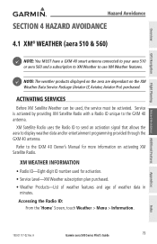
... on the XM Weather Data Service Package (Aviator LT, Aviator, Aviator Pro) purchased. A Garmin aera 500 Series Pilot's Guide 79 Overview GPS Navigation Flight Planning Hazard Avoidance Additional Features Hazard Avoidance Section 4 Hazard Avoidance 4.1 XM® Weather (aera 510 & 560) NOTE: You MUST have a GXM 40 smart antenna connected to your aera 510 or aera 560 and a subscription to XM Weather to the...
... on the XM Weather Data Service Package (Aviator LT, Aviator, Aviator Pro) purchased. A Garmin aera 500 Series Pilot's Guide 79 Overview GPS Navigation Flight Planning Hazard Avoidance Additional Features Hazard Avoidance Section 4 Hazard Avoidance 4.1 XM® Weather (aera 510 & 560) NOTE: You MUST have a GXM 40 smart antenna connected to your aera 510 or aera 560 and a subscription to XM Weather to the...
Pilot's Guide
Page 103
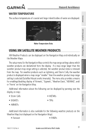
...the map. For weather products such as Lightning, and Storm Cells, the weather product is displayed when a map range "smaller" than the weather product map range setting is selected, the weather product data is selected (Satellite Mosaic works inversely). A Garmin aera 500 Series Pilot's... GPS Navigation Flight Planning Hazard Avoidance Additional Features Water Temperature Data Using XM Satellite Weather Products XM Weather Products can be displayed on the Navigation Map and individually on the Weather Maps. The setup menu for the following can be displayed by panning...
...the map. For weather products such as Lightning, and Storm Cells, the weather product is displayed when a map range "smaller" than the weather product map range setting is selected, the weather product data is selected (Satellite Mosaic works inversely). A Garmin aera 500 Series Pilot's... GPS Navigation Flight Planning Hazard Avoidance Additional Features Water Temperature Data Using XM Satellite Weather Products XM Weather Products can be displayed on the Navigation Map and individually on the Weather Maps. The setup menu for the following can be displayed by panning...
Pilot's Guide
Page 104
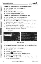
... Map Feature Button to select the desired settings or touch the On/Off Button (if available). 92 Garmin aera 500 Series Pilot's Guide 190-01117-02 Rev. A Index menu option. 4) Touch the Weather 'Show/Hide' Button. Viewing XM Weather products on the Navigation Map: 1) From the 'Home' Screen touch the Map Icon. 2) Touch the Menu...
... Map Feature Button to select the desired settings or touch the On/Off Button (if available). 92 Garmin aera 500 Series Pilot's Guide 190-01117-02 Rev. A Index menu option. 4) Touch the Weather 'Show/Hide' Button. Viewing XM Weather products on the Navigation Map: 1) From the 'Home' Screen touch the Map Icon. 2) Touch the Menu...
Pilot's Guide
Page 105
...: 1) From the 'Home' Screen, touch the Map Icon. Or: a) From the 'Home' Screen, touch the Weather Icon. Animating XM weather: 1) From the 'Home' Screen, touch the Map Icon (weather must be enabled). A Garmin aera 500 Series Pilot's Guide 93 Appendices Index b) Touch the NEXRAD Icon or the Satellite Icon. 2) Touch the Menu Icon. 3) Touch the 'Animate...
...: 1) From the 'Home' Screen, touch the Map Icon. Or: a) From the 'Home' Screen, touch the Weather Icon. Animating XM weather: 1) From the 'Home' Screen, touch the Map Icon (weather must be enabled). A Garmin aera 500 Series Pilot's Guide 93 Appendices Index b) Touch the NEXRAD Icon or the Satellite Icon. 2) Touch the Menu Icon. 3) Touch the 'Animate...
Pilot's Guide
Page 121
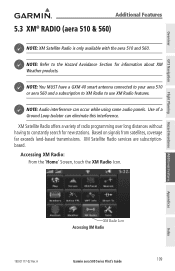
... for information about XM Weather products. NOTE: You MUST have a GXM 40 smart antenna connected to your aera 510 or aera 560 and a subscription to XM Radio to use XM Radio features. XM Satellite Radio services are subscriptionbased. A XM Radio Icon Accessing XM Radio Garmin aera 500 Series Pilot's Guide 109 Overview GPS Navigation Additional Features 5.3 XM® Radio (aera 510 & 560) NOTE: XM Satellite Radio...
... for information about XM Weather products. NOTE: You MUST have a GXM 40 smart antenna connected to your aera 510 or aera 560 and a subscription to XM Radio to use XM Radio features. XM Satellite Radio services are subscriptionbased. A XM Radio Icon Accessing XM Radio Garmin aera 500 Series Pilot's Guide 109 Overview GPS Navigation Additional Features 5.3 XM® Radio (aera 510 & 560) NOTE: XM Satellite Radio...
Pilot's Guide
Page 122
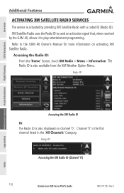
... Additional Features Activating XM Satellite Radio Services The service is also displayed on activating XM Satellite Radio. Radio ID Accessing the XM Radio ID (Channel '0') 110 Garmin aera 500 Series Pilot's Guide 190-01117-02 Rev. XM Satellite Radio uses the... Radio ID to send an activation signal that, when received by providing XM Satellite Radio with a coded ID (Radio ID). Refer to play entertainment programming. Channel '0' is also available from the XM Weather...
... Additional Features Activating XM Satellite Radio Services The service is also displayed on activating XM Satellite Radio. Radio ID Accessing the XM Radio ID (Channel '0') 110 Garmin aera 500 Series Pilot's Guide 190-01117-02 Rev. XM Satellite Radio uses the... Radio ID to send an activation signal that, when received by providing XM Satellite Radio with a coded ID (Radio ID). Refer to play entertainment programming. Channel '0' is also available from the XM Weather...
Pilot's Guide
Page 153
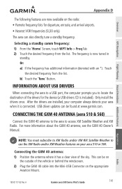
Touch the desired frequency from the list. Connecting the GXM 40 Antenna (aera 510 & 560) Connect the GXM 40 antenna to the aera to use the XM Radio and/or XM Weather features on the appropriate Aviation Mount. A Garmin aera 500 Series Pilot's Guide 141 Overview GPS Navigation Flight Planning Hazard Avoidance Additional Features Appendix D The following features are...
Touch the desired frequency from the list. Connecting the GXM 40 Antenna (aera 510 & 560) Connect the GXM 40 antenna to the aera to use the XM Radio and/or XM Weather features on the appropriate Aviation Mount. A Garmin aera 500 Series Pilot's Guide 141 Overview GPS Navigation Flight Planning Hazard Avoidance Additional Features Appendix D The following features are...
Pilot's Guide
Page 172
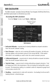
...Figures E6B Calculator • Indicated Altitude-required entry for density altitude/true airspeed calculation. If XM weather information is the temperature of the nearest METAR. A Index Total Air Temperature (TAT) ...XM weather information, the field automatically updates to enter the current barometric pressure. • Calibrated Airspeed- Accessing the E6B calculator: From the 'Home' Screen, touch Tools > E6B Calc. required entry for density altitude/true airspeed calculation. Barometric Pressure from the aircraft's heading indicator or directional gyro. 160 Garmin aera...
...Figures E6B Calculator • Indicated Altitude-required entry for density altitude/true airspeed calculation. If XM weather information is the temperature of the nearest METAR. A Index Total Air Temperature (TAT) ...XM weather information, the field automatically updates to enter the current barometric pressure. • Calibrated Airspeed- Accessing the E6B calculator: From the 'Home' Screen, touch Tools > E6B Calc. required entry for density altitude/true airspeed calculation. Barometric Pressure from the aircraft's heading indicator or directional gyro. 160 Garmin aera...


