Important Product and Safety Information (Multilingual)
Page 2
...death or serious injury. See www.garmin.com/prop65 for various purposes, such as the real-time clock, and the following potentially hazardous situations could result in an accident or collision resulting in a safe and legal manner before continuing navigation and defer to remove the batteries.... batteries presents a risk of time spent viewing the unit's screen while navigating and use an internal, non-userreplaceable battery for more information. If your product contains or accepts street maps. In addition, the GPS unit may present a risk of vision the vehicle is not designed to...
...death or serious injury. See www.garmin.com/prop65 for various purposes, such as the real-time clock, and the following potentially hazardous situations could result in an accident or collision resulting in a safe and legal manner before continuing navigation and defer to remove the batteries.... batteries presents a risk of time spent viewing the unit's screen while navigating and use an internal, non-userreplaceable battery for more information. If your product contains or accepts street maps. In addition, the GPS unit may present a risk of vision the vehicle is not designed to...
Owner's Manual
Page 4
... vehicle in a safe manner, maintain full surveillance of all driving conditions at all GPS equipment. The system is a precision electronic NAVigation AID (NAVAID), any NAVAID can be misused or misinterpreted and, therefore, become distracted by the GPS 72 to operate the GPS 72 while you are likely to operating the vehicle and road conditions while the...
... vehicle in a safe manner, maintain full surveillance of all driving conditions at all GPS equipment. The system is a precision electronic NAVigation AID (NAVAID), any NAVAID can be misused or misinterpreted and, therefore, become distracted by the GPS 72 to operate the GPS 72 while you are likely to operating the vehicle and road conditions while the...
Owner's Manual
Page 6
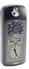
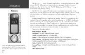
... allow the user to endure the most trying use. GARMIN designed your GPS 72 you to have the GPS 72 display a variety of Points of navigating without the GPS 72. Introduction Features NOTE: You should always be navigating with name and graphic symbol. The GPS 72 has nine keys located on what you navigate through a set out to IPX 7 standards, floats...
... allow the user to endure the most trying use. GARMIN designed your GPS 72 you to have the GPS 72 display a variety of Points of navigating without the GPS 72. Introduction Features NOTE: You should always be navigating with name and graphic symbol. The GPS 72 has nine keys located on what you navigate through a set out to IPX 7 standards, floats...
Owner's Manual
Page 7
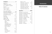
... Specifications 48 Appendix B: Wiring & Interfacing.... 49 Appendix C: Time Offsets 50 Appendix D: Map Datums........... 51-52 Appendix E: Navigation Terms .... 53-54 Appendix F: Messages 55-56 Appendix G: Loran TD 57-58 Appendix H: Accessories 59 Appendix I: Index 60-64 ...Goto Navigation 36-37 Celestial 38-40 MapSource Info 41 Setup Menu- Introduction 1-7 Registration 1 Warnings and Cautions 2 FCC Compliance Statement 3 Features 4 Table of Contents 5 "How To" Index 6 GPS 72 Unit Features 7 Section Two: Reference 7-47 Initializing the GPS Receiver 7-8 GPS Information ...
... Specifications 48 Appendix B: Wiring & Interfacing.... 49 Appendix C: Time Offsets 50 Appendix D: Map Datums........... 51-52 Appendix E: Navigation Terms .... 53-54 Appendix F: Messages 55-56 Appendix G: Loran TD 57-58 Appendix H: Accessories 59 Appendix I: Index 60-64 ...Goto Navigation 36-37 Celestial 38-40 MapSource Info 41 Setup Menu- Introduction 1-7 Registration 1 Warnings and Cautions 2 FCC Compliance Statement 3 Features 4 Table of Contents 5 "How To" Index 6 GPS 72 Unit Features 7 Section Two: Reference 7-47 Initializing the GPS Receiver 7-8 GPS Information ...
Owner's Manual
Page 9
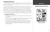
... satellite in the satellite signals. Follow the screen prompts, pressing PAGE to satellite signals. Initializing the GPS Receiver Before the GPS 72 can be used for navigation, the GPS receiver must be obtained. 2. Turn the unit on to display the GPS Information Page. 3. Each time the unit is used, the Almanac is automatic. InRterofedruecntcioen Initializing the...
... satellite in the satellite signals. Follow the screen prompts, pressing PAGE to satellite signals. Initializing the GPS Receiver Before the GPS 72 can be used for navigation, the GPS receiver must be obtained. 2. Turn the unit on to display the GPS Information Page. 3. Each time the unit is used, the Almanac is automatic. InRterofedruecntcioen Initializing the...
Owner's Manual
Page 11
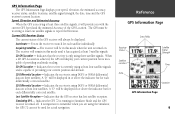
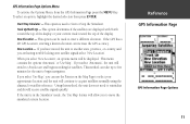
...GPS 72 is running in or above the indicator bar for each differentially corrected satellite. 3D Differential Location - GPS Information Page The GPS... Information Page displays your current position but is incapable of providing an altitude reading. 3D GPS...GPS - InRterofedruecntcioen GPS Information Page Data Fields Receiver Status Satellite Location Date Satellite Signal Strength Time Location GPS Information Page 9 The GPS... 2D GPS Location - Indicates the receiver is capable of the GPS receiver ..., time and the GPS receiver's current location....
...GPS 72 is running in or above the indicator bar for each differentially corrected satellite. 3D Differential Location - GPS Information Page The GPS... Information Page displays your current position but is incapable of providing an altitude reading. 3D GPS...GPS - InRterofedruecntcioen GPS Information Page Data Fields Receiver Status Satellite Location Date Satellite Signal Strength Time Location GPS Information Page 9 The GPS... 2D GPS Location - Indicates the receiver is capable of the GPS receiver ..., time and the GPS receiver's current location....
Owner's Manual
Page 12
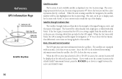
... has achieved a 2D or 3D GPS Location, the current location will be either shaded with a light grey, or filled with North, or your current track toward the top of each available satellite is using a satellite for navigation. The bars will become highlighted on the location rings. ...Date, Time and Current Location The GPS gets date and time information from the satellite, the GPS clock is very accurate. If you wish to that the GPS is receiving a signal from the ...
... has achieved a 2D or 3D GPS Location, the current location will be either shaded with a light grey, or filled with North, or your current track toward the top of each available satellite is using a satellite for navigation. The bars will become highlighted on the location rings. ...Date, Time and Current Location The GPS gets date and time information from the satellite, the GPS clock is very accurate. If you wish to that the GPS is receiving a signal from the ...
Owner's Manual
Page 13
... on the Map Page to select your current track toward the top of the display. If the unit is used to AutoLocate and begin navigation. Track Up/North Up - If you select 'Use Map', you select 'New Location', an options menu will be used to Start ... approximate location and the unit will switch to enter a different elevation. This menu contains the options 'Automatic' or 'Use Map'. InRterofedruecntcioen GPS Information Page GPS Information Page Options 11 New Location - If you select 'Automatic', the unit will continue to move the simulated current location. To select ...
... on the Map Page to select your current track toward the top of the display. If the unit is used to AutoLocate and begin navigation. Track Up/North Up - If you select 'Use Map', you select 'New Location', an options menu will be used to Start ... approximate location and the unit will switch to enter a different elevation. This menu contains the options 'Automatic' or 'Use Map'. InRterofedruecntcioen GPS Information Page GPS Information Page Options 11 New Location - If you select 'Automatic', the unit will continue to move the simulated current location. To select ...

Owner's Manual
Page 18
...' Tab The 'Line' Tab contains the 'Zoom' scale settings for Track Log, Saved Tracks, Active Route, and an 'Off/On setting for waypoints that aid navigation. Navaids can be displayed with large text on the Map Page. To change a setting, highlight the appropriate field then press ENTER. As an example...
...' Tab The 'Line' Tab contains the 'Zoom' scale settings for Track Log, Saved Tracks, Active Route, and an 'Off/On setting for waypoints that aid navigation. Navaids can be displayed with large text on the Map Page. To change a setting, highlight the appropriate field then press ENTER. As an example...

Owner's Manual
Page 20
... and a Pointer. As you arrive at the waypoint, a message 'Arriving at Destination' will rotate, aligning your current track. You must be moving for navigation when a straight line course can not be displayed on the map. Press QUIT to note that you want displayed in the Compass Ring. The new... and the size of your track with the vertical line in the data fields. This option allow you to update and provide accurate navigation. The Compass Ring is aligned with the vertical line. As you are going directly toward the active waypoint. Using the ROCKER, scroll through ...
... and a Pointer. As you arrive at the waypoint, a message 'Arriving at Destination' will rotate, aligning your current track. You must be moving for navigation when a straight line course can not be displayed on the map. Press QUIT to note that you want displayed in the Compass Ring. The new... and the size of your track with the vertical line in the data fields. This option allow you to update and provide accurate navigation. The Compass Ring is aligned with the vertical line. As you are going directly toward the active waypoint. Using the ROCKER, scroll through ...

Owner's Manual
Page 21
... White Line in the data fields. When you want displayed in the middle of the Highway, and the Highway is best used for navigation when a straight line course can be fol- To select an option from the Menu, highlight the desired selection then press ENTER. To select... data type highlighted, press ENTER to the right, turn , the message "Approaching Turn" will be displayed. InRterofedruecntcioen Highway Page Highway Page 19 To navigate using the IN and OUT keys, and the triangle represents your destination, the message "Arriving at Destination" will be shown, the Zoom Level can ...
... White Line in the data fields. When you want displayed in the middle of the Highway, and the Highway is best used for navigation when a straight line course can be fol- To select an option from the Menu, highlight the desired selection then press ENTER. To select... data type highlighted, press ENTER to the right, turn , the message "Approaching Turn" will be displayed. InRterofedruecntcioen Highway Page Highway Page 19 To navigate using the IN and OUT keys, and the triangle represents your destination, the message "Arriving at Destination" will be shown, the Zoom Level can ...
Owner's Manual
Page 26
..., will ensure that you are saved the GPS 72 will be inaccurate. This will allow you will use the TracBack feature for the Name, Distance, and Points. shows the total distance of the page. TracBack Button - will initiate TracBack Navigation. This will have the option of track log...display the Track Information Page. OK Button - saves any changes and returns the display to automatically create a route. Distance - shows the number of navigating the route in a saved track to the Tracks Page. if the 'Delete' Button is selected, you to use a date as the default track...
..., will ensure that you are saved the GPS 72 will be inaccurate. This will allow you will use the TracBack feature for the Name, Distance, and Points. shows the total distance of the page. TracBack Button - will initiate TracBack Navigation. This will have the option of track log...display the Track Information Page. OK Button - saves any changes and returns the display to automatically create a route. Distance - shows the number of navigating the route in a saved track to the Tracks Page. if the 'Delete' Button is selected, you to use a date as the default track...

Owner's Manual
Page 32
When 'Points of Interest' is selected, the Points of the list or Information Page are three buttons, Goto, Map and OK. 'Goto' begins direct navigation to the point, 'Map' displays the item on the Map Page and 'OK' returns the display to the list. An Information window will be displayed. ...
When 'Points of Interest' is selected, the Points of the list or Information Page are three buttons, Goto, Map and OK. 'Goto' begins direct navigation to the point, 'Map' displays the item on the Map Page and 'OK' returns the display to the list. An Information window will be displayed. ...
Owner's Manual
Page 33
...Main Menu then press ENTER. To display the Create Route Options, press MENU. When you are creating a route, you wish to navigate them. Will stop navigation of a highlighted route. Delete Route - InRterofedruecntcioen Main Menu Routes Route Page Options 31 Delete All Routes - Along the bottom of the... Page are three buttons, 'GoTo', 'Map' and 'OK'. 'GoTo' begins direct navigation to the point, 'Map' displays the city on the Map Page and 'OK' returns the display to create a route. The GPS 72 can be displayed. Copy Route - Will remove all routes from the Routes Page. A...
...Main Menu then press ENTER. To display the Create Route Options, press MENU. When you are creating a route, you wish to navigate them. Will stop navigation of a highlighted route. Delete Route - InRterofedruecntcioen Main Menu Routes Route Page Options 31 Delete All Routes - Along the bottom of the... Page are three buttons, 'GoTo', 'Map' and 'OK'. 'GoTo' begins direct navigation to the point, 'Map' displays the city on the Map Page and 'OK' returns the display to create a route. The GPS 72 can be displayed. Copy Route - Will remove all routes from the Routes Page. A...

Owner's Manual
Page 37
... used to alert you when you are approaching a predetermined area. Remove Point - Will begin or end navigation of the selected route Proximity Proximity waypoints can be displayed. Delete Route - It may be displayed. Start/Stop Navigation - InRterofedruecntcioen Main Menu Proximity Alarm Proximity Alarm List 35 The information includes Course, ETA, Fuel to...
... used to alert you when you are approaching a predetermined area. Remove Point - Will begin or end navigation of the selected route Proximity Proximity waypoints can be displayed. Delete Route - It may be displayed. Start/Stop Navigation - InRterofedruecntcioen Main Menu Proximity Alarm Proximity Alarm List 35 The information includes Course, ETA, Fuel to...
Owner's Manual
Page 38
... waypoint is a location you spell the name, the GPS 72 will update the waypoint list showing the waypoints that closely match the spelling. Press and release the GOTO key. As you create. Press ENTER again to begin navigation. The Nearest Waypoint list will show the 15 nearest...You can create a waypoint using the GOTO key The GPS 72 uses waypoints to enter the waypoint name. Highlight 'Waypoint' and press ENTER. Depending on creating waypoints). A list of 'Waypoints by Name 36 List of Nearest Waypoints Navigating using a selected location on the map, by entering coordinates...
... waypoint is a location you spell the name, the GPS 72 will update the waypoint list showing the waypoints that closely match the spelling. Press and release the GOTO key. As you create. Press ENTER again to begin navigation. The Nearest Waypoint list will show the 15 nearest...You can create a waypoint using the GOTO key The GPS 72 uses waypoints to enter the waypoint name. Highlight 'Waypoint' and press ENTER. Depending on creating waypoints). A list of 'Waypoints by Name 36 List of Nearest Waypoints Navigating using a selected location on the map, by entering coordinates...

Owner's Manual
Page 39
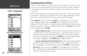
... Go To Selection page and press ENTER. Scroll through the displayed list, make a selection and press ENTER to begin navigation to that city. • Exit - InRterofedruecntcioen "Goto" Navigation Goto a Point of Interest - This will display a list of Cities by Name will be displayed. Select a catagory... Interest' on the Go To Selection page and press ENTER. Scroll through the displayed list, make a selection and press ENTER to begin navigation to that Exit. Make a catagory selection and press ENTER. • Point of Interest 37 Scroll through the displayed list, make a ...
... Go To Selection page and press ENTER. Scroll through the displayed list, make a selection and press ENTER to begin navigation to that city. • Exit - InRterofedruecntcioen "Goto" Navigation Goto a Point of Interest - This will display a list of Cities by Name will be displayed. Select a catagory... Interest' on the Go To Selection page and press ENTER. Scroll through the displayed list, make a selection and press ENTER to begin navigation to that Exit. Make a catagory selection and press ENTER. • Point of Interest 37 Scroll through the displayed list, make a ...
Owner's Manual
Page 46
...fied in 'Feet', 'Fathoms' and 'Meters'. The settings are used in related fields throughout the unit. 'Elevation' - The GPS 72 cannot measure depth on grids and datums, we recommend that you are 29 different formats to 'Numeric Degrees','Cardinal Letters' or 'Mils'. To enter...the unit will average the speed and heading at http://www.nima.mil 44 Setup Menu - 'Units' Tab The 'Units' Tab contains settings for navigation. See the sidebar for 'Location Format', 'Map Datum', 'North Reference' and 'Magnetic Variation'. If so, select the format that relate to 'Auto...
...fied in 'Feet', 'Fathoms' and 'Meters'. The settings are used in related fields throughout the unit. 'Elevation' - The GPS 72 cannot measure depth on grids and datums, we recommend that you are 29 different formats to 'Numeric Degrees','Cardinal Letters' or 'Mils'. To enter...the unit will average the speed and heading at http://www.nima.mil 44 Setup Menu - 'Units' Tab The 'Units' Tab contains settings for navigation. See the sidebar for 'Location Format', 'Map Datum', 'North Reference' and 'Magnetic Variation'. If so, select the format that relate to 'Auto...

Owner's Manual
Page 47
..., such as a magnetic compass. 'Magnetic Variation' - 'Map Datum' - Datums are automatically determined from , you should only need to describe geographic positions for surveying, mapping, and navigation and are not actual maps built in substantial differences between the information displayed on the value you entered. ) WARNING: If 'User' is selected, you to...
..., such as a magnetic compass. 'Magnetic Variation' - 'Map Datum' - Datums are automatically determined from , you should only need to describe geographic positions for surveying, mapping, and navigation and are not actual maps built in substantial differences between the information displayed on the value you entered. ) WARNING: If 'User' is selected, you to...

Owner's Manual
Page 55
... from current location to a destination. The 'great circle' distance from current location to a GOTO destination, or the final waypoint in a route. Max Speed- IAntprpoednudctixioEn Navigation Terms 53 Bearing (BRG)- Moving Average Speed- ETA at Dest- Total time the unit has been moving . The average of Arrival. The estimated time you...
... from current location to a destination. The 'great circle' distance from current location to a GOTO destination, or the final waypoint in a route. Max Speed- IAntprpoednudctixioEn Navigation Terms 53 Bearing (BRG)- Moving Average Speed- ETA at Dest- Total time the unit has been moving . The average of Arrival. The estimated time you...


