

Owner's Manual
Page 17
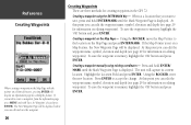
... on the Map Page is decreased. Lat Lon Grids will begin displaying on the grid. The 'Zoom' setting for 'Grid Labels' to display the coordinates on the Map Page. InRterofedruecntcioen Map Page Options Setup Map - 'Map' Tab 15 Setup Map - 'Waypoint' Tab The 'Waypoint Tab contains the ...'Map' Tab contains settings for all waypoints. This option allows you to be displayed in the unit. Make your new selection then press ENTER to accept the selection. Each of the options has a 'Text' and 'Zoom' setting. To change a setting, highlight the appropriate field then...
... on the Map Page is decreased. Lat Lon Grids will begin displaying on the grid. The 'Zoom' setting for 'Grid Labels' to display the coordinates on the Map Page. InRterofedruecntcioen Map Page Options Setup Map - 'Map' Tab 15 Setup Map - 'Waypoint' Tab The 'Waypoint Tab contains the ...'Map' Tab contains settings for all waypoints. This option allows you to be displayed in the unit. Make your new selection then press ENTER to accept the selection. Each of the options has a 'Text' and 'Zoom' setting. To change a setting, highlight the appropriate field then...
Owner's Manual
Page 28
... on the Map Page and press ENTER/MARK. Creating a waypoint using existing coordinates - To save the waypoint to memory, highlight the 'OK' button and press ENTER. At this point you can edit the waypoint name, symbol, elevation and depth (see page 29 for creating waypoints in the GPS 72. The unit will be displayed where...
... on the Map Page and press ENTER/MARK. Creating a waypoint using existing coordinates - To save the waypoint to memory, highlight the 'OK' button and press ENTER. At this point you can edit the waypoint name, symbol, elevation and depth (see page 29 for creating waypoints in the GPS 72. The unit will be displayed where...
Owner's Manual
Page 38
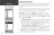
...displays the Go To Selection page. Highlight 'Waypoint' and press ENTER. To display the nearest list, press MENU and with 'Find Nearest' highlighted press ENTER. • Finding a waypoint by name - If you spell the name, the GPS 72 will show the 15 nearest waypoints within 100 miles. As you... by Name 36 List of Nearest Waypoints Navigating using a selected location on the map, by entering coordinates, or by marking a location while actually there (see the waypoint on the list, press ENTER, and scroll through the list until the waypoint is to these locations. Press and release the...
...displays the Go To Selection page. Highlight 'Waypoint' and press ENTER. To display the nearest list, press MENU and with 'Find Nearest' highlighted press ENTER. • Finding a waypoint by name - If you spell the name, the GPS 72 will show the 15 nearest waypoints within 100 miles. As you... by Name 36 List of Nearest Waypoints Navigating using a selected location on the map, by entering coordinates, or by marking a location while actually there (see the waypoint on the list, press ENTER, and scroll through the list until the waypoint is to these locations. Press and release the...

Owner's Manual
Page 59
...is approximately thirty meters. Since the GPS 72 does not rely on the LORAN signal for ocean and coastal navigation. LORAN TD Feature The LORAN TD (Time Delay) feature eases the transition from this conversion is stored in memory. Position coordinates may be expected from using LORAN...the Setup TD field. The LORAN system covers the entire United States and the U.S. The GPSMAP unit automatically converts GPS coordinates to using LORAN TD coordinates, you enter a different LORAN chain number, change the secondary stations or offsets in the Setup TD field, the active waypoint...
...is approximately thirty meters. Since the GPS 72 does not rely on the LORAN signal for ocean and coastal navigation. LORAN TD Feature The LORAN TD (Time Delay) feature eases the transition from this conversion is stored in memory. Position coordinates may be expected from using LORAN...the Setup TD field. The LORAN system covers the entire United States and the U.S. The GPSMAP unit automatically converts GPS coordinates to using LORAN TD coordinates, you enter a different LORAN chain number, change the secondary stations or offsets in the Setup TD field, the active waypoint...

Owner's Manual
Page 60
... press the PAGE Key to return to select the Loran GRI-Chain Number, Primary and Secondary Stations, and TD Offsets. Remember that the GPS is located under the Units tab in the world. 58 The 'LORAN TD Setup' window contains the fields to the Main Menu....waypoint will now reference the active GRI-chain and secondary stations and adjust the TD coordinates accordingly. Because of the five fields, highlight the field, press ENTER select/ enter the desired setting then press ENTER. 4. IAnptrpoednudcitxioGn Loran TD The LORAN Position Format field is not relying ...
... press the PAGE Key to return to select the Loran GRI-Chain Number, Primary and Secondary Stations, and TD Offsets. Remember that the GPS is located under the Units tab in the world. 58 The 'LORAN TD Setup' window contains the fields to the Main Menu....waypoint will now reference the active GRI-chain and secondary stations and adjust the TD coordinates accordingly. Because of the five fields, highlight the field, press ENTER select/ enter the desired setting then press ENTER. 4. IAnptrpoednudcitxioGn Loran TD The LORAN Position Format field is not relying ...


