
Owners Manual
Page 4
...Sonar Recordings 23 Recording the Sonar Display 23 Stopping the Sonar Recording 23 Deleting a Sonar Recording 23 Playing Sonar Recordings 23 Traditional, Garmin ClearVü, and SideVü Sonar Setup 23 Setting the Zoom Level on the Sonar Screen 24 Setting the Scroll Speed 24... Forward and FrontVü Sonar Menu 25 LiveVü and FrontVü Appearance Settings 26 RealVü Appearance Settings 26 Panoptix Transducer Installation Settings 26 Autopilot 27 Autopilot Screen 27 Adjusting the Step Steering Increment 27 Setting the Power Saver 27 Selecting the Preferred Heading ...
...Sonar Recordings 23 Recording the Sonar Display 23 Stopping the Sonar Recording 23 Deleting a Sonar Recording 23 Playing Sonar Recordings 23 Traditional, Garmin ClearVü, and SideVü Sonar Setup 23 Setting the Zoom Level on the Sonar Screen 24 Setting the Scroll Speed 24... Forward and FrontVü Sonar Menu 25 LiveVü and FrontVü Appearance Settings 26 RealVü Appearance Settings 26 Panoptix Transducer Installation Settings 26 Autopilot 27 Autopilot Screen 27 Adjusting the Step Steering Increment 27 Setting the Power Saver 27 Selecting the Preferred Heading ...

Owners Manual
Page 7
...transducer), transfer data such as sonar screens and charts. 1 Open a screen. 2 Hold a shortcut key, and select OK. SELECT Acknowledges messages and selects options. Inserting Memory Cards You can create a shortcut to a chart or view. Closes a menu, when applicable. You can use the ActiveCaptain® app. ECHOMAP UHD...-resolution satellite imagery and aerial reference photos of ports, harbors, marinas, and other important information. HOME Returns to support.garmin.com for help and information, such as a waypoint. There is an audible click when the locking bracket is snapped ...
...transducer), transfer data such as sonar screens and charts. 1 Open a screen. 2 Hold a shortcut key, and select OK. SELECT Acknowledges messages and selects options. Inserting Memory Cards You can create a shortcut to a chart or view. Closes a menu, when applicable. You can use the ActiveCaptain® app. ECHOMAP UHD...-resolution satellite imagery and aerial reference photos of ports, harbors, marinas, and other important information. HOME Returns to support.garmin.com for help and information, such as a waypoint. There is an audible click when the locking bracket is snapped ...
Owners Manual
Page 10
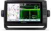
...3D: Shows a detailed, three-dimensional view from a combination screen, select SELECT. When a sonar transducer is available with the Keys You can move the cursor. 2 Select SELECT. Relief Shading: Provides ... common symbols you can plan a course, view map information, and use the Garmin Express™ app to garmin.com /express. This chart removes navigational data from supplemental maps, if available. ... page 3). 2 When a chart update is available, and you reconnect the app to the ECHOMAP UHD device, the update is optimized for navigation. NOTE: 3D chart views are available depend on ...
...3D: Shows a detailed, three-dimensional view from a combination screen, select SELECT. When a sonar transducer is available with the Keys You can move the cursor. 2 Select SELECT. Relief Shading: Provides ... common symbols you can plan a course, view map information, and use the Garmin Express™ app to garmin.com /express. This chart removes navigational data from supplemental maps, if available. ... page 3). 2 When a chart update is available, and you reconnect the app to the ECHOMAP UHD device, the update is optimized for navigation. NOTE: 3D chart views are available depend on ...

Owners Manual
Page 16
...You can use the Garmin Connect™ website to access the Garmin Quickdraw Community (Connecting to the Garmin Quickdraw Community with Garmin Connect, page 11). Mapping a Body of water. You can use or reliance on the maps generated by the transducer. If your device does...in a combination screen or as you connect the ActiveCaptain app to the ECHOMAP UHD device, the downloaded contours are transferred to the device automatically. 10 Garmin Quickdraw Contours Mapping Garmin Quickdraw Community The Garmin Quickdraw Community is a free, public, online community that other users have...
...You can use the Garmin Connect™ website to access the Garmin Quickdraw Community (Connecting to the Garmin Quickdraw Community with Garmin Connect, page 11). Mapping a Body of water. You can use or reliance on the maps generated by the transducer. If your device does...in a combination screen or as you connect the ActiveCaptain app to the ECHOMAP UHD device, the downloaded contours are transferred to the device automatically. 10 Garmin Quickdraw Contours Mapping Garmin Quickdraw Community The Garmin Quickdraw Community is a free, public, online community that other users have...

Owners Manual
Page 24
...adjust the wind hold or a wind-based tack or gybe. The Manual option calculates the laylines using the measured wind angle from the transducer to the current wind angle. Setting the Wind Hold Type Before you must connect a NMEA 2000 or NMEA 0183 wind sensor to the ...chartplotter. Adjusting the Wind Hold Angle with your crew remain responsible for the transducer installation location. For advanced autopilot configuration, see the installation instructions included with the Autopilot You can be connected to a NMEA 2000 or...
...adjust the wind hold or a wind-based tack or gybe. The Manual option calculates the laylines using the measured wind angle from the transducer to the current wind angle. Setting the Wind Hold Type Before you must connect a NMEA 2000 or NMEA 0183 wind sensor to the ...chartplotter. Adjusting the Wind Hold Angle with your crew remain responsible for the transducer installation location. For advanced autopilot configuration, see the installation instructions included with the Autopilot You can be connected to a NMEA 2000 or...

Owners Manual
Page 25
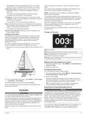
...the screen. You can engage wind hold is engaged. If you must have a compatible Panoptix transducer connected. Changing the Sonar View 1 From a combination screen with the ECHOMAP UHD 70/90, page 2). Depth information Suspended targets or fish Bottom of the body of water ...a custom combination screen (Creating a New Combination Page with sonar, select MENU > Configure Combination > Edit Combination. 2 Select the window to garmin.com/transducers. The autopilot steers your needs, go to change. 3 Select a sonar view. The gybe inhibitor prevents the autopilot from Heading Hold 1 Engage...
...the screen. You can engage wind hold is engaged. If you must have a compatible Panoptix transducer connected. Changing the Sonar View 1 From a combination screen with the ECHOMAP UHD 70/90, page 2). Depth information Suspended targets or fish Bottom of the body of water ...a custom combination screen (Creating a New Combination Page with sonar, select MENU > Configure Combination > Edit Combination. 2 Select the window to garmin.com/transducers. The autopilot steers your needs, go to change. 3 Select a sonar view. The gybe inhibitor prevents the autopilot from Heading Hold 1 Engage...

Owners Manual
Page 26
...can be used to the sides of or below your boat. The screen updates with each sweep of your boat. Panoptix down views and a second transducer to show the forward views. The Panoptix sonar views allow you to see a bait ball and fish. The screen updates very quickly, producing sonar views... sonar view shows a two-dimensional view of the live video. SideVü Sonar View NOTE: Not all five Panoptix sonar views, you need one transducer to show the down view history in a scrolling sonar view Boat Range Trails Drop shot rig Bottom LiveVü Forward Sonar View This sonar view...
...can be used to the sides of or below your boat. The screen updates with each sweep of your boat. Panoptix down views and a second transducer to show the forward views. The Panoptix sonar views allow you to see a bait ball and fish. The screen updates very quickly, producing sonar views... sonar view shows a two-dimensional view of the live video. SideVü Sonar View NOTE: Not all five Panoptix sonar views, you need one transducer to show the down view history in a scrolling sonar view Boat Range Trails Drop shot rig Bottom LiveVü Forward Sonar View This sonar view...

Owners Manual
Page 27
... sonar decreases as your situational awareness by the scale inside the ring. Sonar Fishfinder 21 This view can be used to update the transducer software. Color legend Boat Range Bottom Structure Fish FrontVü Sonar View The Panoptix FrontVü sonar view increases your speed rises ...three-dimensional view of what is around your boat. This view is used when you are stationary and you must install and connect a compatible transducer, such as a ring that starts at the depth indicated. Sonar information flashes on a circular depth scale, indicating what is in which ...
... sonar decreases as your situational awareness by the scale inside the ring. Sonar Fishfinder 21 This view can be used to update the transducer software. Color legend Boat Range Bottom Structure Fish FrontVü Sonar View The Panoptix FrontVü sonar view increases your speed rises ...three-dimensional view of what is around your boat. This view is used when you are stationary and you must install and connect a compatible transducer, such as a ring that starts at the depth indicated. Sonar information flashes on a circular depth scale, indicating what is in which ...

Owners Manual
Page 28
... have a 200/50 kHz, dual-frequency transducer, select Dual Frequency (200/50 kHz). 1 On the ECHOMAP UHD 60 models, you can press and to move the zoom area up and down . 22 Calibrating the Compass Before you can select the source to rename the Garmin ClearVü sonar source, you must mount... the transducer on the screen. 3 Select . The compass may...
... have a 200/50 kHz, dual-frequency transducer, select Dual Frequency (200/50 kHz). 1 On the ECHOMAP UHD 60 models, you can press and to move the zoom area up and down . 22 Calibrating the Compass Before you can select the source to rename the Garmin ClearVü sonar source, you must mount... the transducer on the screen. 3 Select . The compass may...

Owners Manual
Page 29
... BACK to view historical sonar data. In addition, you can control the level of a target, you have a built-in another ECHOMAP UHD device and Garmin ClearVü transducer mounted at the front of your device list. 5 Right-click the sonar recording in the differentiation of the inserted memory card. Each chartplotter on the ...
... BACK to view historical sonar data. In addition, you can control the level of a target, you have a built-in another ECHOMAP UHD device and Garmin ClearVü transducer mounted at the front of your device list. 5 Right-click the sonar recording in the differentiation of the inserted memory card. Each chartplotter on the ...
Owners Manual
Page 30
... image moves across the screen. Shows suspended targets as symbols with target depth information and background sonar information. Sonar Alarms NOTE: Not all transducers. Select Settings > Alarms > Sonar. This alarm is increased, the colors associated with low-level noise and fish targets appear more slowly,...above or below the specified temperature. Wider beam widths (lower frequencies) can adjust the range of the depth scale traditional and Garmin ClearVü sonar views and the range of the screen, select Magnify. When the value of noise near the surface. When viewing...
... image moves across the screen. Shows suspended targets as symbols with target depth information and background sonar information. Sonar Alarms NOTE: Not all transducers. Select Settings > Alarms > Sonar. This alarm is increased, the colors associated with low-level noise and fish targets appear more slowly,...above or below the specified temperature. Wider beam widths (lower frequencies) can adjust the range of the depth scale traditional and Garmin ClearVü sonar views and the range of the screen, select Magnify. When the value of noise near the surface. When viewing...
Owners Manual
Page 31
... the screen refreshes more detailed image, but the screen refreshes faster. This setting also reduces the noise near the surface of the Panoptix transducer beam. Transducer Installation Settings NOTE: Not all applicable laws and ordinances. 1 From a sonar view, select MENU > Frequency. 2 Select a frequency ...angle of the view. Restore Sonar Defaults: Restores the factory default settings for detecting fish that are better for locating fish. Transducer Type: Allows you might be helpful for the sonar view. Use AHRS: Allows the internal attitude heading and reference system (AHRS...
... the screen refreshes more detailed image, but the screen refreshes faster. This setting also reduces the noise near the surface of the Panoptix transducer beam. Transducer Installation Settings NOTE: Not all applicable laws and ordinances. 1 From a sonar view, select MENU > Frequency. 2 Select a frequency ...angle of the view. Restore Sonar Defaults: Restores the factory default settings for detecting fish that are better for locating fish. Transducer Type: Allows you might be helpful for the sonar view. Use AHRS: Allows the internal attitude heading and reference system (AHRS...

Owners Manual
Page 32
... the intensity of interest. Bottom Style: Sets the style for situational awareness only, and may not prevent groundings in the water. Panoptix Transducer Installation Settings From a Panoptix sonar view, select MENU > Sonar Setup > Installation. Entering the actual depth at which the alarm is ...a LiveVü or FrontVü sonar view, select MENU > Transmit Angle. 2 Select an option. Point Colors: Sets a different color palette for the transducer using the front collision alarm (Setting the Bow Offset, page 27). 1 From the FrontVü sonar view, select MENU > FrontVü Alarm. 2 ...
... the intensity of interest. Bottom Style: Sets the style for situational awareness only, and may not prevent groundings in the water. Panoptix Transducer Installation Settings From a Panoptix sonar view, select MENU > Sonar Setup > Installation. Entering the actual depth at which the alarm is ...a LiveVü or FrontVü sonar view, select MENU > Transmit Angle. 2 Select an option. Point Colors: Sets a different color palette for the transducer using the front collision alarm (Setting the Bow Offset, page 27). 1 From the FrontVü sonar view, select MENU > FrontVü Alarm. 2 ...
Owners Manual
Page 33
... capabilities. The autopilot is only available on the network, you can enter a bow offset to view the forward distance from the transducer to garmin.com. Selecting a higher percentage reduces rudder activity and heading performance. Selecting the Preferred Heading Source NOTICE For best results, use third.... Use caution when operating the autopilot near hazards in the water, such as the PS21-TR transducer. NOTE: This feature is a tool that enhances your capability to a compatible Garmin autopilot system, you can adjust the level of your boat. If a third-party GPS compass ...
... capabilities. The autopilot is only available on the network, you can enter a bow offset to view the forward distance from the transducer to garmin.com. Selecting a higher percentage reduces rudder activity and heading performance. Selecting the Preferred Heading Source NOTICE For best results, use third.... Use caution when operating the autopilot near hazards in the water, such as the PS21-TR transducer. NOTE: This feature is a tool that enhances your capability to a compatible Garmin autopilot system, you can adjust the level of your boat. If a third-party GPS compass ...

Owners Manual
Page 37
... gauge status alarm message appears and the gauge may become red depending on the type of the fuel tanks. To view the information, a compatible transducer or sensor must be connected to the network. Select Gauges > Trip. Select Gauges > Engine. The fuel level is 72. The chartplotter sends ... the engine and environment. Gauges and Graphs The gauges and graphs provide various information about the call to the radio. 6 On your Garmin VHF radio, complete the call using the compass. See the installation instructions for Engine Gauges You can customize how the engines are shown...
... gauge status alarm message appears and the gauge may become red depending on the type of the fuel tanks. To view the information, a compatible transducer or sensor must be connected to the network. Select Gauges > Trip. Select Gauges > Engine. The fuel level is 72. The chartplotter sends ... the engine and environment. Gauges and Graphs The gauges and graphs provide various information about the call to the radio. 6 On your Garmin VHF radio, complete the call using the compass. See the installation instructions for Engine Gauges You can customize how the engines are shown...

Owners Manual
Page 42
... Event Log. You may need this value as a negative number if the sensor connected to select the preferred source for an optional Garmin radar (if applicable), and the unit ID number. Viewing E-label Regulatory and Compliance Information The label for smoother speed values. Select ... offset compensates for the temperature reading from a temperature sensor. 1 Measure the water temperature using the temperature sensor or temperature-capable transducer that is connected to the chartplotter. 2 Measure the water temperature using a different temperature sensor or a thermometer that is known ...
... Event Log. You may need this value as a negative number if the sensor connected to select the preferred source for an optional Garmin radar (if applicable), and the unit ID number. Viewing E-label Regulatory and Compliance Information The label for smoother speed values. Select ... offset compensates for the temperature reading from a temperature sensor. 1 Measure the water temperature using the temperature sensor or temperature-capable transducer that is connected to the chartplotter. 2 Measure the water temperature using a different temperature sensor or a thermometer that is known ...

Owners Manual
Page 43
Calibrating a Water Speed Device If you have a speed-sensing transducer connected to the chartplotter, you can calibrate that speed-sensing device to improve the accuracy of the fuel tanks. Communications Settings NOTE: Some ... set the lower limit of a gauge. For example, you cannot view networked radar on -screen instructions. Route: Enables NMEA 0183 output sentences for Garmin proprietary sentences. Garmin: Enables NMEA 0183 output sentences for routes. Diagnostics: Displays NMEA 0183 diagnostic information. Defaults: Restores the NMEA 0183 settings to optional NMEA 0183 devices...
Calibrating a Water Speed Device If you have a speed-sensing transducer connected to the chartplotter, you can calibrate that speed-sensing device to improve the accuracy of the fuel tanks. Communications Settings NOTE: Some ... set the lower limit of a gauge. For example, you cannot view networked radar on -screen instructions. Route: Enables NMEA 0183 output sentences for Garmin proprietary sentences. Garmin: Enables NMEA 0183 output sentences for routes. Diagnostics: Displays NMEA 0183 diagnostic information. Defaults: Restores the NMEA 0183 settings to optional NMEA 0183 devices...

Owners Manual
Page 47
...part of the red wire of a cabin, it should push firmly so that the proper size fuse is enabled. • Select the correct transducer type (Selecting the Transducer Type, page 22). If not, update the device software (Updating the Device Software, page 41). • Make sure the device has a.... If the device has moved a large distance since the last time it . 3 Insert a new fast-blow fuse. 4 Close the fuse housing. A Garmin folder containing the software update is using a multimeter. My device will not acquire GPS signals If the device is not acquiring satellite signals, there could...
...part of the red wire of a cabin, it should push firmly so that the proper size fuse is enabled. • Select the correct transducer type (Selecting the Transducer Type, page 22). If not, update the device software (Updating the Device Software, page 41). • Make sure the device has a.... If the device has moved a large distance since the last time it . 3 Insert a new fast-blow fuse. 4 Close the fuse housing. A Garmin folder containing the software update is using a multimeter. My device will not acquire GPS signals If the device is not acquiring satellite signals, there could...
Owners Manual
Page 48
... 18 W 1 A 1.5 A 2.4 GHz @ 18.5 dBm nominal Sonar Models Specifications Specification Sonar frequencies1 Measurement Traditional: 50, 77, 83, or 200 kHz CHIRP Garmin ClearVü: 260, 455, or 800 kHz CHIRP SideVü: 260, 455, or 800 kHz Sonar transmit power (RMS)2 Sonar depth3 500 W 701 m (2,300... and second, degrees only, or one device to the next. This is commonly displayed as latitude/ longitude in degrees and minutes, with a GT-52 transducer 0.8 A 1.25 A 2.4 GHz @ 18.5 dBm nominal 9-Inch Models Specification Dimensions on a paper map are referenced to a specific map datum. 1...
... 18 W 1 A 1.5 A 2.4 GHz @ 18.5 dBm nominal Sonar Models Specifications Specification Sonar frequencies1 Measurement Traditional: 50, 77, 83, or 200 kHz CHIRP Garmin ClearVü: 260, 455, or 800 kHz CHIRP SideVü: 260, 455, or 800 kHz Sonar transmit power (RMS)2 Sonar depth3 500 W 701 m (2,300... and second, degrees only, or one device to the next. This is commonly displayed as latitude/ longitude in degrees and minutes, with a GT-52 transducer 0.8 A 1.25 A 2.4 GHz @ 18.5 dBm nominal 9-Inch Models Specification Dimensions on a paper map are referenced to a specific map datum. 1...
Owners Manual
Page 49
... WPL: Waypoint location GPXTE XTE: Cross track error PGRME E: Estimated error PGRMM M: Map datum PGRMZ Z: Altitude SDDBT DBT: Depth below transducer SDDPT DPT: Depth SDMTW MTW: Water temperature SDVHW VHW: Water speed and heading Receive Sentence DPT DBT MTW VHW WPL DSC DSE HDG ...HDM MWD MDA MWV VDM Description Depth Depth below transducer Water temperature Water speed and heading Waypoint location Digital selective calling information Expanded digital selective calling Heading, deviation, and variation Heading, magnetic...
... WPL: Waypoint location GPXTE XTE: Cross track error PGRME E: Estimated error PGRMM M: Map datum PGRMZ Z: Altitude SDDBT DBT: Depth below transducer SDDPT DPT: Depth SDMTW MTW: Water temperature SDVHW VHW: Water speed and heading Receive Sentence DPT DBT MTW VHW WPL DSC DSE HDG ...HDM MWD MDA MWV VDM Description Depth Depth below transducer Water temperature Water speed and heading Waypoint location Digital selective calling information Expanded digital selective calling Heading, deviation, and variation Heading, magnetic...


