
BlueChart g2 User's Guide North America
Page 18
...information from Current Stations around the United States coastline, including Alaska and Hawaii (on preloaded Garmin units) as well as western Canada and several Caribbean islands (on preprogrammed data cards). level... on viewing tide and current information on the Map Page; Tide Prediction Stations are indicated with a icon on your Garmin unit. 10 BlueChart g2 User's Guide Current Stations are denoted with a icon. Local time Tide station High tide curve... g2 cartography, you can also access current information from more than 3,000 Tide Prediction Stations across the world.
...information from Current Stations around the United States coastline, including Alaska and Hawaii (on preloaded Garmin units) as well as western Canada and several Caribbean islands (on preprogrammed data cards). level... on viewing tide and current information on the Map Page; Tide Prediction Stations are indicated with a icon on your Garmin unit. 10 BlueChart g2 User's Guide Current Stations are denoted with a icon. Local time Tide station High tide curve... g2 cartography, you can also access current information from more than 3,000 Tide Prediction Stations across the world.
BlueChart g2 User's Guide Worldwide
Page 17
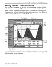
... with a icon. Tide Prediction Stations are indicated with a icon on your Garmin unit. Viewing BlueChart g2 > Viewing Tide and Current Information Viewing Tide and Current Information Using BlueChart g2 cartography, you can also access current information from more than 3,000 Tide Prediction Stations across the world. level Tide height High tide curve...
... with a icon. Tide Prediction Stations are indicated with a icon on your Garmin unit. Viewing BlueChart g2 > Viewing Tide and Current Information Viewing Tide and Current Information Using BlueChart g2 cartography, you can also access current information from more than 3,000 Tide Prediction Stations across the world. level Tide height High tide curve...