
Garmin eTrex 10 Support Question
Garmin eTrex 10 Support Question
Find answers below for this question about Garmin eTrex 10.Need a Garmin eTrex 10 manual? We have 2 online manuals for this item!
Question posted by mikeemily on March 28th, 2013
How To Set Language Back To English
it on a different language and i cant get it on english
Current Answers
Related Garmin eTrex 10 Manual Pages
Owner's Manual - Page 3

... 22 chirp 23
Applications 24 Sharing Data 24 Setting a Proximity Alarm 24 Calculating the Size of Contents
Getting Started 5 Device Overview 5 Using the eTrex Keys 6 Battery Information 7 Turning the Device ...9 Waypoints 9 Using Sight 'N Go 10 Where To? Table of an Area....25 Using the Calculator 25 Viewing the Calendar and
Almanacs 25 Setting an Alarm 26 Opening the Stopwatch 26...
Owner's Manual - Page 8

...solid green, your device has acquired satellite signals.
When the GPS bars on the backlight page (page 40) are set automatically based on , it begins acquiring satellite signals.
The ...a safe place.
8
eTrex Owner's Manual
Getting Started
Turning the Device On or Off
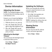
Hold . Registering Your Device
• Go to acquire satellite signals. For more information about GPS, go to http://www...
Owner's Manual - Page 21

...it in .
5. Creating and Saving a Geocache Filter You can create and save the filter, select back. eTrex Owner's Manual
21 Select Setup > Geocaches > Filter Setup > Create Filter.
Select Geocaches > menu > Apply... list, select Search.
• To save custom filters for hidden treasures using GPS coordinates posted online by those hiding the geocache. Geocaches
A geocache is when you...
Owner's Manual - Page 24

...information wirelessly. Setting a Proximity Alarm
Proximity alarms alert you when you enter a proximity alarm area, the device sounds a tone (eTrex 20/30).
24
eTrex Owner's ...Manual Select a location.
5. Enter a radius.
7.
Select Send or Receive. 3. Select Done.
Select Share Wirelessly. 2. Select Proximity Alarms.
2. Select Use.
6. When you are within 10...
Owner's Manual - Page 26

...to the satellite in the view and to be oriented with your current location, GPS accuracy, satellite locations, and signal strength.
The alarm sounds at the alarm time,...GPS Select Satellite > menu > Use With GPS Off.
26
eTrex Owner's Manual Satellite Page
The satellite page shows your current track toward the top of that satellite (eTrex 20/30). Select an option. Applications
Setting...
Owner's Manual - Page 27

Select a location.
4. Select Use. Select menu > Set Location On Map.
3. Applications
eTrex Owner's Manual
27 Select Satellite > menu > Use With GPS Off.
2.
Simulating a Location Before you can simulate a location, you must turn off GPS (page 26).
1.
Owner's Manual - Page 30

... note: Changing the text language does not change the language of time before the backlight turns off ). Deleting a Profile 1. System Settings
Select Setup > System.
• GPS-sets the GPS to Normal, WAAS/EGNOS ...waas.html.
• Language-sets the text language on the device. Note: To adjust the backlight brightness, see page 40.
• Colors (eTrex 20/30)-sets the colors that display ...
Owner's Manual - Page 33

...different position format. Select a unit of measure for distance and speed, elevation, and pressure.
1.
Select Setup > Position Format.
• Position Format-sets the position format in which a given location reading appears. Changing the Units of Measure
You can select Automatic to set... setting.
• Color (eTrex 20/30)-changes the color of the track line on your tracks. eTrex ...
Owner's Manual - Page 34

... from an electronic compass to a GPS compass when you to self-calibrate each time you turn the device on the compass.
• North Reference-sets the north reference of the compass....Line (Pointer)-allows you are traveling at a higher rate of speed for a set period of directional heading on .
34
eTrex Owner's Manual Select Setup > Altimeter.
• Auto Calibration-allows the altimeter...
Owner's Manual - Page 40
... data or settings. Move the Thumb Stick left and
right to http://www.garmin.com /products/webupdater.
2. Select Setup > About.
40
eTrex Owner's Manual
While the device is low. note: Updating the software does not erase any of screen backlighting can decrease the backlight timeout to adjust the contrast level (eTrex 10 only). Move...
Owner's Manual - Page 47

... GPS location is compatible with your Garmin device.
• Before you turn on the Garmin device and only takes a few seconds when the accessories are available for your exact location. eTrex ... with Your Garmin Device • Verify that the ANT+ accessory
is accurate to within range (10 ft. or 3 m) of error for all data fields are activated and functioning correctly.
• ...
Owner's Manual - Page 49
...rate of speed at which you are moving since last reset. The average speed of the selected settings. Your heart rate in the selected position format.
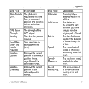
GPS Signal Strength Heading
Heart Rate (heart rate monitor required) Location (lat/lon)
Location (selected)
...the current position in beats per minute (bpm).
The maximum speed reached since last reset. eTrex Owner's Manual
49
Owner's Manual - Page 50

...difference (in which
Good
you must move to return to Next
To Course
Description
Your average speed since last reset. The estimated time needed to reach the next waypoint on your time settings... The time of sunrise based on your GPS position.
Trip Time Stopped
The time spent...closing on a
destination along a
route.
50
eTrex Owner's Manual
Trip Time Moving
A running tally ...
Owner's Manual - Page 55

... display backlight timeout 30 screen capture 30 settings 30 downloading geocaches 21 software 40 driving routes 37
E editing
profiles 30 routes 12 waypoints 9
eTrex Owner's Manual
elevation plot 19, 20 ... attempt 22 navigating to 22 settings 35 GPS signals 8, 26, 30, 47, 49, 52 turning off 26
H heading settings 34 HomePort 43
Index
hunting times 25
K keys 5, 6
L language 30 locking ring 6
M ...
Owner's Manual - Page 56

... GPS 26, 27
saving tracks 15
sharing data 24 Sight N' Go 10 software
updating 40 version 40 stopwatch 26 storing the device 42 sunrise and sunset times 25, 50 system settings 30
T text size, maps 32 time
alarms 26 data fields 50 settings 33 sunrise and sunset
25, 50 zone 33 tones 31
56
eTrex...
Quick Start Manual - Page 2
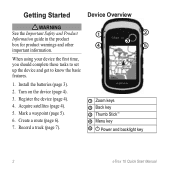
... to set up the device and get to know the basic features.
1. Acquire satellites (page 4).
5. Register the device (page 4).
4. Turn on the device (page 4).
3. Record a track (page 7).
➊
➋
➌
➍
➎
➊ Zoom keys ➋ Back key ➌ Thumb Stick™ ➍ Menu key
➎ Power and backlight key
2
eTrex 10 Quick...
Quick Start Manual - Page 4
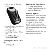
.... Hold (page 2). 5. The device may need a clear view of the sky to acquire satellite signals.
When the GPS bars on the backlight page (page 5) are set automatically based on , it begins acquiring satellite signals. eTrex 10 Quick Start Manual The time and date are solid, your device has acquired satellite signals. Replace the battery...
Quick Start Manual - Page 5
...settings and views can be limited when the remaining capacity in the device.
Select Mark Waypoint.
2. Select a waypoint.
3.
Waypoints
Waypoints are using the device for geocaching and for navigating on how you record and store in the batteries is on, press .
2. eTrex 10... Quick Start Manual
5 Adjusting the Screen
Note: The backlight brightness may be different when ...
Quick Start Manual - Page 7
... record tracks at a variable rate that creates an optimum representation of your track.
3.
eTrex 10 Quick Start Manual
7 The track log contains information about points along the recorded path, ...distance, and select Done. Select Record Method.
4. Tracks
A track is created.
Use this setting only if you move with the device turned on the map indicates your path. Select Recording ...
Quick Start Manual - Page 8
...
1. Select Go. Complete one or more actions: • Use the Thumb Stick to move the map to different areas. • Select ▲ and ▼ to a USB port on your route marked with your computer.
2. eTrex 10 Quick Start Manual Select a destination. 4.
The map page opens with a magenta line. 5. Select Map. Connecting to a destination...
Similar Questions

Storage Problem On Gps Etrex 10
When I try to store anything on my eTrex 10, I get this message appear on the screen. "There is not ...
When I try to store anything on my eTrex 10, I get this message appear on the screen. "There is not ...
(Posted by derekhill108 8 years ago)

How Do I Set Up A Garmin Etrex 10 To Work With Map Point
(Posted by jax7Sarahp 9 years ago)

How To Change Forerunner 210 Settings To English
(Posted by soniHal 10 years ago)


What Languages Text Setting Are Available On Garmin Etrex 20
(Posted by huckre 10 years ago)