
Garmin eTrex 10 Support Question
Garmin eTrex 10 Support Question
Find answers below for this question about Garmin eTrex 10.Need a Garmin eTrex 10 manual? We have 2 online manuals for this item!
Question posted by seanmtucker on January 6th, 2013
Delete Active Route
I have deleted a route in the route planner, but I still see the route line in the map. Also, I still see the route under active route. How can I delete the route from the map and route planner?
Current Answers
Related Garmin eTrex 10 Manual Pages
Owner's Manual - Page 3

...30 Display Settings 30
3 Menu 11 Routes 12 Tracks 14
Navigation 16 Navigating to a Destination..........16 Map 16 Compass 17 Elevation Plot 19 Trip Computer 20
eTrex Owner's Manual
Table of Contents
Geocaches...Getting Started 5 Device Overview 5 Using the eTrex Keys 6 Battery Information 7 Turning the Device On or Off.........8 Satellite Signals 8 Registering Your Device 8
...
Owner's Manual - Page 9

Select Done. Deleting a Waypoint 1. eTrex Owner's Manual
9 Waypoints, Routes, and Tracks
Finding a Waypoint 1. Select an item to edit, and select Done. Select a waypoint.
Select a waypoint. 3.
Waypoints, Routes, and Tracks
Waypoints
Waypoints are locations you must create a waypoint.
1. Select an option:
• To save your current location as a waypoint.
1. Select ...
Owner's Manual - Page 10

Select Waypoint Averaging.
2. Select Start.
5. Waypoints, Routes, and Tracks
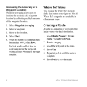
Increasing the Accuracy of a Waypoint Location Waypoint averaging allows you to increase the accuracy of a waypoint location... 90 minutes between samples. Select a unit of the waypoint location.
1. Move to the object, and select Done > Save.
10
eTrex Owner's Manual Using Sight 'N Go
Sight 'N Go is available on the...
Owner's Manual - Page 13

Select a point.
5. Select Route Planner. 2. Deleting a Route 1. While navigating a route, select
Active Route. 2. Select back to view
additional details. Select a route. 3. Viewing the Active Route 1.
Select Edit Route.
4.
Waypoints, Routes, and Tracks
Viewing a Route on the route, select Insert. Select View Map. Select a route. 3. Select a route. 3. The additional point is ...
Owner's Manual - Page 15

...8226; Select Save Portion, and select a portion. Select View Map. Select menu > Review Track. Select Track Manager. 2. Select Delete > Yes. Viewing Track Information 1. Information about the track is ... saved tracks to save memory space.
1. Select a saved track. 3.
eTrex Owner's Manual
15
Waypoints, Routes, and Tracks
Viewing the Elevation Plot of the track are marked by flags...
Owner's Manual - Page 17

...
3.
Select Profile Change > Automotive.
2. Navigation
Compass
The eTrex 30 has a 3-axis, electronic compass. To improve heading...power lines.
Use the map to navigate to use the map, you must purchase and load City Navigator maps....eTrex Owner's Manual
17 TIP: When the device is only available on the map, and the bar at the top of the map.
Navigating a Driving Route Driving route...
Owner's Manual - Page 24

...
Applications
Sharing Data
The eTrex 30 can send or receive data when connected to another compatible device. Setting a Proximity Alarm
Proximity alarms alert you when you are within 10 feet (3 m) of ...a particular location.
1. Select a location.
5. Sending and Receiving Data Wirelessly Before you can share waypoints, geocaches, routes, and tracks....
Owner's Manual - Page 30

... > Profiles. 2. Select Delete > Yes. Select Setup > Profiles. 2. Select a profile. 3. note: Changing the text language does not change the language of user-entered data or map data, such as street names.
• Battery Type-allows you are using. Select Done.
Note: To adjust the backlight brightness, see page 40.
• Colors (eTrex 20/30...
Owner's Manual - Page 36
...; Searching-page 23.
• Program chirp™-programs the chirp accessory.
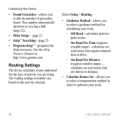
Select Setup > Routing.
• Guidance Method-allows you log a find (page 22).
• Filter Setup- calculates on the activity selected.
Routing Settings
The device calculates routes optimized for calculating your route.
36
eTrex Owner's Manual See the chirp Owner's Manual at http://www.garmin.com.
Owner's Manual - Page 37

...; Nautical-displays various map features in different colors so that the marine POIs are within a specified distance of bottom contours and depth soundings.
• Lock On Road-locks the position icon, which represents your current point.
• Avoidance Setup-(available only for some activities.
◦◦ Auto-automatically routes you to the next...
Owner's Manual - Page 47

... uncalibrated environmental pressure.
eTrex Owner's Manual
47 or 10 m) away from only your Garmin device automatically recognizes the ANT+ accessory each time it is activated.
Total
Description
The margin... fields are activated and functioning correctly.
• When paired, your Garmin device receives data from other accessories. The average vertical distance of GPS
Ambient Pressure
...
Owner's Manual - Page 50

...reset.
The estimated time needed to reach the next waypoint on a
destination along a
route.
50
eTrex Owner's Manual
The current time of the distance traveled since the last reset. Trip Time... reset.
L
means turn right.
The estimated time needed to your
destination and your GPS position. Trip Time Stopped
The time spent not moving since last reset. R
means turn...
Owner's Manual - Page 54

...53
fitness 46 acquiring satellite
signals 52 active route 13 addresses 12 advanced map setup 32 alarms
clock 26 marine 38...type 7 storage 7 warnings 7 BirdsEye satellite imagery 11 BlueChart g2 maps 11
54
C calculator 25 calendar 25 calibrating
altimeter 20 compass 18 caring ... 42 long-term storage 42 chirp 23 City Navigator maps 17 compass 17 calibrating 18 navigating 18 restore 39 setup...
Owner's Manual - Page 55

device settings 30-39 profiles 29
D data fields 28
options 47 deleting
files 45 profiles 30 routes 13 tracks 15 waypoints 9 display backlight timeout 30 screen capture 30 settings 30 downloading geocaches 21 software 40 driving routes 37
E editing
profiles 30 routes 12 waypoints 9
eTrex Owner's Manual
elevation plot 19, 20 barometric altimeter 20 of a track...
Owner's Manual - Page 56

... 52 elevation plot 20 restoring default settings 39 routes 12-13 active route 13 avoidance 37 creating 12 deleting 13 editing 13 navigating 13 settings 36
S satellite signals 8, 26, 47,
49, 52 system settings 30 turning off GPS 26, 27
saving tracks 15
sharing data 24 Sight N' Go 10 software
updating 40 version 40 stopwatch 26...
Owner's Manual - Page 57
... 15 setup 32 viewing 15
track up 31 transferring files 44
using USB 44 wirelessly 24 trip computer 20 restore 39 troubleshooting 52
W waypoints 9-10
averaging 10 creating 9 deleting 9 editing 9 navigating to 16 WebUpdater 40 Where To? 11
Z zooming 32
U unit ID 40 units of measure 33 updating software 40 USB cable 52...
Quick Start Manual - Page 2
...;
➎
➊ Zoom keys ➋ Back key ➌ Thumb Stick™ ➍ Menu key
➎ Power and backlight key
2
eTrex 10 Quick Start Manual
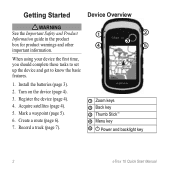
Mark a waypoint (page 5).
6. Install the batteries (page 3).
2. Create a route (page 6).
7. Getting Started
Device Overview
‹ warning See the Important Safety and Product Information guide in the product box for...
Quick Start Manual - Page 4
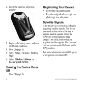
...it begins acquiring satellite signals. Insert the batteries, observing polarity.
3.
For more information about GPS, go to http://my.garmin.com. • Keep the original sales receipt, or a
...Type. 6. Satellite Signals
After the device is turned on the GPS position. Select Alkaline, Lithium, or
Rechargeable NiMH.
eTrex 10 Quick Start Manual Replace the battery cover, and turn the D-...
Quick Start Manual - Page 6
...
4. Creating a Route
A route is
complete. 6. Move to . Menu
You can use the Where To? Select Route Planner > Create Route > Select First ...maps. Select a waypoint.
3. Select back to eight samples for the waypoint, waiting at least 90 minutes between samples. For best results, collect four to save the route.
6
eTrex 10 Quick Start Manual categories are available in the route...
Quick Start Manual - Page 8
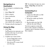
... route marked with a magenta line. 5. Connect the USB cable to a USB port on Windows computers and as removable drives in and out of the USB cable into the mini-USB port.
Select Map. Your device appears as a mounted volume on the map. The position icon represents your location on Mac computers. Select Where To?. 2.
eTrex 10...
Similar Questions

Storage Problem On Gps Etrex 10
When I try to store anything on my eTrex 10, I get this message appear on the screen. "There is not ...
When I try to store anything on my eTrex 10, I get this message appear on the screen. "There is not ...
(Posted by derekhill108 8 years ago)

How To Completely Delete Activities Forerunner 610
(Posted by JoWlm 10 years ago)


Using A Route On An Etrex 19
I am new to gps when I use a route on the unit, does it automatically progress to the next waypoint ...
I am new to gps when I use a route on the unit, does it automatically progress to the next waypoint ...
(Posted by Bnmnnook 11 years ago)