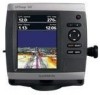
Garmin GPSMAP 541s Support Question
Garmin GPSMAP 541s Support Question
Find answers below for this question about Garmin GPSMAP 541s - Marine GPS Receiver.Need a Garmin GPSMAP 541s manual? We have 8 online manuals for this item!
Question posted by dnilsson360 on September 21st, 2013
Garmin 541s Depth Flashes
Depth flashes when in 40' deep water then goes to 17' while flashing will go to 137' Doesn't do it all the time.
Current Answers
Related Garmin GPSMAP 541s Manual Pages
Installation Instructions - Page 8
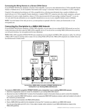
...a Garmin CANet Device If your GPSMAP 400/500 series chartplotter is Garmin CANet-compatible, it can receive sonar...GPSMAP 400/500 Series Chartplotter to an Existing NMEA 2000 Network
To connect a NMEA 2000-compatible GPSMAP 400/500 series chartplotter to your local Garmin dealer or marine...two CANet compatible Garmin chartplotters. A standard NMEA 0183 connection only allows depth, temperature, and...
Technical Reference for Garmin NMEA 2000 Products - Page 4
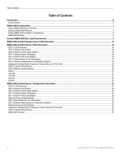
... 10 (Garmin Water Speed and Temperature Adapter)...19 Intelliducer (Intelligent Depth Transducer-Transom Mount and Thru-Hull)...19 GWS 10 (Garmin Wind Sensor)...20 GHP 10 (Marine Autopilot System)...20 GXM 51...21 VHF 200...21 VHF 300...21 AIS 300...22 AIS 600...22
NMEA 2000-Certified Sensor Configuration Information...23 GPS 17x (GPS Antenna)...23...
Technical Reference for Garmin NMEA 2000 Products - Page 22
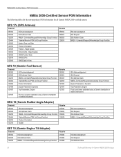
... PGN information for Garmin NMEA 2000 Products Rapid Update GNSS Position Data GNSS DOPs GNSS Sats in View
059392 059904 060928 126208
ISO Acknowledgment ISO Request ISO Address Claim NMEA - Command/Request/Acknowledge Group Function Transmit/Receive PGN List Group Function System Time and Date Product Information Position - GPS 17x (GPS Antenna)
Transmit
Receive
059392 060928...
Technical Reference for Garmin NMEA 2000 Products - Page 23

... ISO Address Claim
059904
ISO Request
126208 NMEA-Command/Request/Acknowledge Group Function 060928
ISO Address Claim
126464 Transmit/Receive PGN List Group Function
126208
NMEA-Command/Request/Acknowledge Group Function
126996 Product Information
128267 Water Depth
130312 Temperature
Technical Reference for Garmin NMEA 2000 Products 19 Command/Request/Acknowledge Group Function
GFL 10...
Technical Reference for Garmin NMEA 2000 Products - Page 40
.... To configure the wind speed filter: 1. Select the angle in degrees to adjust for Garmin NMEA 2000 Products
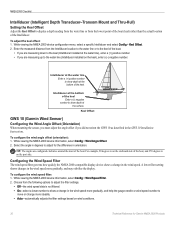
Intelliducer at the bottom of the Intelliducer.
A lower filter setting shows changes... angle offset if you are measuring up to show depth at the surface. Intelliducer at the water line Enter a (+) positive number to show depth at the bottom of the boat, and 270 degrees...
Owner's Manual - Page 16

... to most charts include depth contour lines (with a Garmin Intelliducer™ attached).
• Fuel-(available only when your chartplotter is on.
Using Charts
• Fishing-turn the Depth, Water Temperature, and Water Speed data bar on or off (available when using an "s" series unit with a transducer attached, or a "non-s" series unit with deep water represented in white...
Owner's Manual - Page 23
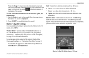
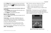
...information. Mariner's Eye 3D (Water Hazard Colors) GPSMAP 400/500 Series Owner's Manual 17 Use the Rocker to point to view details about navaids such as seen from the water. ...water. When the cursor is very shallow water.
Mariner's Eye 3D Settings To access additional settings or options from the Mariner's Eye 3D
screen, press MENU.
Blue indicates deep water, yellow is shallow water...
Owner's Manual - Page 41

... and specified boat safe depth to determine the best course to your computer for a three-dimensional navigation aid (page 16).
Navigating with NMEA 2000 compatible chartplotters (GPSMAP 441/441s, GPSMAP 536/536s, GPSMAP 541/541s, and GPSMAP 546/546s). You can...computer for a realistic view of the land and water on BlueChart g2 Vision-compatible Garmin GPS units and when using HomePort.
Owner's Manual - Page 59
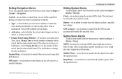
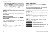
...screen, select Configure > Alarms > System.
Deep Water-set an alarm to sound only when nearing...GPS location accuracy falls outside the specified value.
Off Course-set an alarm to sound when you are within a specified distance or time from the Home screen, select Configure > Alarms > Navigation.
If you exceed a specified drift distance. Note: You must be receiving NMEA sonar depth...
Owner's Manual - Page 60
...the depth of a keel, making it possible to measure depth ...from the transducer location.
Enter this value in step 3 as a positive number.
You can configure your boat, from the transducer to the water...marine, tornado, severe
storm, flood, or flash...receive fuel-level information, your unit must have a subscription to XM WX Weather and a connected Garmin XM WX weather receiver...
Owner's Manual - Page 65
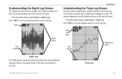
... the scale for the log.
Temp and depth
Time elapsed
Temperature range
Depth Log
The depth appears along the right side, and the time elapsed appears along the bottom.
Depth
Time elapsed
Depth range
Using Sonar
Understanding the Temp Log Screen
If you are shown in the top-left corner. Temp Log
GPSMAP 400/500 Series Owner's Manual
59...
Owner's Manual - Page 86
... Below Transducer-you attempted to add more than 250 points to transfer on the SD card. Deep Water Alarm-the Deep Water Alarm depth has been reached. Entering Safe Region-the boat is approaching a safe region as defined by the Water Temperature Alarm.
Route Truncated-an uploaded route from an SD card that does not contain...
Owner's Manual - Page 91

...mariner's eye 3D 16 navigation 8 settings 12 cleaning the unit 82
Clear User Data 44 close hauled wind gauge 42 collision alarm 26 colors, hazard 17 Color Scheme 61 Communications 51 Compass 36 compass rose 12 contact information, Garmin...deep water 53 fish 54 fuel 54 GPS accuracy 53 navigation 53 off course 53 shallow water 53 sonar 53 water... waypoint 31 depth line 60 depth log 59 depth waypoint 61...
Owner's Manual - Page 16

...8226; Sailing-turn off . Select Wind to which you turn the Water Speed, Wind Speed, Wind Angle, and Wind Velocity Made Good ...GPSMAP 400/500 Series Owner's Manual
Wind VMG appears under these conditions:
• The Sailing data bar displays Wind VMG when you are navigating a route or an automatic guidance line and you
want to most charts include depth contour lines (with deep water...
Owner's Manual - Page 23
...'s Manual
Mariner's Eye 3D (Water Hazard Colors) 17 The Off setting shows the land as beacons, lights, and obstructions: 1. Mariner's Eye 3D Settings To access additional settings or options from the Mariner's Eye 3D screen, press MENU. Press the Range (-) key to move the view closer to your boat and lower to the water.
Blue indicates deep water...
Owner's Manual - Page 39
...deep-sea fishing.
• High Resolution Satellite Imagery-provides high-resolution satellite images for a realistic view of the land and water on the chart.
• Fishing Charts-provides a view of the chart with a Garmin...GPSMAP 400/500 Series Owner's Manual
33 The BlueChart g2 Vision Mariner... and specified boat safe depth to determine the best ...g2 Vision-compatible Garmin GPS units. Note: ...
Owner's Manual - Page 52
... a specified drift distance. Battery-set an alarm to sound when the GPS location accuracy falls outside the specified value. GPS Accuracy-set an alarm to sound when the battery reaches a specified low voltage.
Deep Water-set an alarm to sound when the depth is greater than the specified value. If you have Activation set to...
Owner's Manual - Page 53
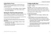
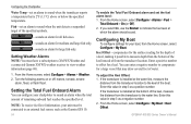
To receive fuel-level information, your chartplotter to sound an alarm when the total amount of a keel, making it possible to the water line (transducer installed on or off: marine, tornado, severe
storm, flood, or flash flood.
Configuring the Chartplotter
Configuring My Boat
To configure settings for the depth of remaining onboard fuel reaches the specified...
Owner's Manual - Page 78

... the Water Temperature Alarm.
Entering (Leaving) target water temperature-the target water temperature ...in your dealer or Garmin Product Support to have ...MMSI-enter a valid MMSI. NMEA Depth Is Below Transducer-you entered a... distress call has been received. DSC Position Report Received From-shows the MMSI ... on the SD card. Deep Water Alarm-the Deep Water Alarm depth has been reached. Use ...
Owner's Manual - Page 83
... aerial photos 20 AIS 22, 40, 48, 59
symbols 23 threats 26 AIS Alarm 49 alarms 45, 71-74 AIS 49 arrival 45 battery 46 clock 46 collision 26, 49 deep water 46 fish 46 fuel 47 GPS accuracy 46 navigation 45 safe-zone 49 shallow water 46 sonar 46 water temp 46 weather 47 Appearance...
Similar Questions


Ais 3000 Sauna Flashing Lo All The Time What Is The Problem
ais3000 cedrus infrared sauna flashing lo all the time
ais3000 cedrus infrared sauna flashing lo all the time
(Posted by garywattsesq 8 years ago)

Gps/map 541s Has No Power
I have tring all conection have their is no power
I have tring all conection have their is no power
(Posted by harrypage 9 years ago)

541s Marine Gps. Depth Not Reading Out.
Depth has been working since installed. Now blank. Is there an on off control for this that may have...
Depth has been working since installed. Now blank. Is there an on off control for this that may have...
(Posted by therad50 11 years ago)

Compass Rose On The Garmin Gps 541s
how do I shut off the compass rose on the garmin gps 541S ?
how do I shut off the compass rose on the garmin gps 541S ?
(Posted by pdstark4 12 years ago)