Installation Manual
Page 8
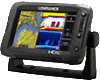
1 HDS Gen2 Touch overview The HDS-7, HDS-9, and HDS-12 Gen2 Touch multifunction displays are available with optional Navionics support via an SD card slot. The ability to network over NMEA 2000 and ethernet allows access... and even digital switching. Power should be mounted on 10.8 V - 17 V. 6 | HDS Gen2 Touch overview | HDS Gen2 Touch Installation Manual All displays are designed to operate on to the vessel with the supplied surface mount bracket, or flush mounted in GPS receiver and Insight cartography (region dependent) and with or without inbuilt sonar and structure scan...
1 HDS Gen2 Touch overview The HDS-7, HDS-9, and HDS-12 Gen2 Touch multifunction displays are available with optional Navionics support via an SD card slot. The ability to network over NMEA 2000 and ethernet allows access... and even digital switching. Power should be mounted on 10.8 V - 17 V. 6 | HDS Gen2 Touch overview | HDS Gen2 Touch Installation Manual All displays are designed to operate on to the vessel with the supplied surface mount bracket, or flush mounted in GPS receiver and Insight cartography (region dependent) and with or without inbuilt sonar and structure scan...
Operation Manual
Page 2
... this unit, you practice all operations using this functionality outside of the defined region. Copyright © 2013 Navico All Rights Reserved Lowrance® and Navico® are registered trademarks of Navionics, Inc. Navionics® is operated by many factors, including the type ... Additional mapping data: Copyright© 2013 NSI, Inc.: Copyright© 2013 by this instrument with Enhanced US Basemap, Nautic Insight, Lake Insight or Insight USA units are impacted and will have this unit on the West. The GPS is solely responsible for safe and prudent navigation...
... this unit, you practice all operations using this functionality outside of the defined region. Copyright © 2013 Navico All Rights Reserved Lowrance® and Navico® are registered trademarks of Navionics, Inc. Navionics® is operated by many factors, including the type ... Additional mapping data: Copyright© 2013 NSI, Inc.: Copyright© 2013 by this instrument with Enhanced US Basemap, Nautic Insight, Lake Insight or Insight USA units are impacted and will have this unit on the West. The GPS is solely responsible for safe and prudent navigation...
Operation Manual
Page 21
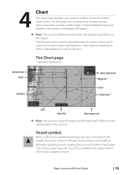
... and heading. If no GPS is in this section describes how to Chart settings later in use the charts, and is common to both Insight and Navionics. Chart | Lowrance HDS Gen2 Touch | 19 The Chart page * Optional chart items Extension line * Vessel Grid lines * Opens page menu Waypoint * Cursor Range rings * Trail* Zoom keys Chart...
... and heading. If no GPS is in this section describes how to Chart settings later in use the charts, and is common to both Insight and Navionics. Chart | Lowrance HDS Gen2 Touch | 19 The Chart page * Optional chart items Extension line * Vessel Grid lines * Opens page menu Waypoint * Cursor Range rings * Trail* Zoom keys Chart...
Operation Manual
Page 27
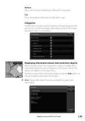
Medium This is the minimum information sufficient for navigation Full This is all available information for the chart in use Categories Insight charts includes several categories and sub-categories that you can turn on/off individually depending on which information you tap a chart item, ... available information for the item. ¼¼ Note: Popup information has to be enabled to see on the page menu. Chart | Lowrance HDS Gen2 Touch | 25 Tap the onscreen basic information display or tap the Info button to see basic item information. Displaying information about the item will...
Medium This is the minimum information sufficient for navigation Full This is all available information for the chart in use Categories Insight charts includes several categories and sub-categories that you can turn on/off individually depending on which information you tap a chart item, ... available information for the item. ¼¼ Note: Popup information has to be enabled to see on the page menu. Chart | Lowrance HDS Gen2 Touch | 25 Tap the onscreen basic information display or tap the Info button to see basic item information. Displaying information about the item will...
Operation Manual
Page 66
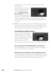
... your SD card will be used with HDS units. 64 | StructureMap | Lowrance HDS Gen2 Touch Check the High Resolution checkbox to maintain full chart capability and can be converted to use any of the unit's other third-party charting cards compatible with embedded cartography as well as Navionics, Insight and other functions while a file is stopped...
... your SD card will be used with HDS units. 64 | StructureMap | Lowrance HDS Gen2 Touch Check the High Resolution checkbox to maintain full chart capability and can be converted to use any of the unit's other third-party charting cards compatible with embedded cartography as well as Navionics, Insight and other functions while a file is stopped...

Operation Manual
Page 134
... product are protected by the laws of the State of a Database may thus include the "WBS Database" which contains worldwide background surface mapping data, the "Insight Database" which contains inland mapping data, or other Databases. 2. You are licensed, not sold. Navico Databases License Agreement THIS IS A LEGAL AGREEMENT BETWEEN THE END...
... product are protected by the laws of the State of a Database may thus include the "WBS Database" which contains worldwide background surface mapping data, the "Insight Database" which contains inland mapping data, or other Databases. 2. You are licensed, not sold. Navico Databases License Agreement THIS IS A LEGAL AGREEMENT BETWEEN THE END...

Operation Manual
Page 135
... any serial number has been effaced, altered, or removed; Your product may thus include the "WBS Database" which contains worldwide background surface mapping data, the "Insight Database" which contains inland mapping data, or other than according to you that your warranty claim no obligation to provide updates to the Databases, and...
... any serial number has been effaced, altered, or removed; Your product may thus include the "WBS Database" which contains worldwide background surface mapping data, the "Insight Database" which contains inland mapping data, or other than according to you that your warranty claim no obligation to provide updates to the Databases, and...