Important Safety and Product Information
Page 2
... the consumer. NOTE: Refer to your product's owner's manual to determine if your boat. Caring for various purposes, such as safe for the screen) using an eyeglass lens cleaner (that may use of Conformity Hereby, Garmin, declares that this unit only as a waste ...or watching the video input while the boat is prohibitively expensive. replaceable battery. • When disposing of Conformity, go to www.garmin.com/compliance. Cleaners containing ammonia, alcohol, abrasives, or antigrease detergents will harm the anti-reflective coating. In some inaccurate or ...
... the consumer. NOTE: Refer to your product's owner's manual to determine if your boat. Caring for various purposes, such as safe for the screen) using an eyeglass lens cleaner (that may use of Conformity Hereby, Garmin, declares that this unit only as a waste ...or watching the video input while the boat is prohibitively expensive. replaceable battery. • When disposing of Conformity, go to www.garmin.com/compliance. Cleaners containing ammonia, alcohol, abrasives, or antigrease detergents will harm the anti-reflective coating. In some inaccurate or ...

Installation Instructions
Page 7
...or Rx/A +) wire on the wiring harness of the NMEA 0183 device. 3. GPSMAP 400/500 Series Chartplotter + - See the GPSMAP 400/500 Series Owner's Manual for more information. The maximum current is 100 mA, and a relay is needed to limit the current from the GPSMAP 400/500 wiring harness to... lamp, a horn, or both, to sound or flash an alert when the chartplotter displays a message. GPSMAP 400/500 Series Installation Instructions 7 For Garmin devices, the ground (black) wires serve as NMEA 0183 ground and must be connected to a low-voltage state when the alarm sounds. Refer to the...
...or Rx/A +) wire on the wiring harness of the NMEA 0183 device. 3. GPSMAP 400/500 Series Chartplotter + - See the GPSMAP 400/500 Series Owner's Manual for more information. The maximum current is 100 mA, and a relay is needed to limit the current from the GPSMAP 400/500 wiring harness to... lamp, a horn, or both, to sound or flash an alert when the chartplotter displays a message. GPSMAP 400/500 Series Installation Instructions 7 For Garmin devices, the ground (black) wires serve as NMEA 0183 ground and must be connected to a low-voltage state when the alarm sounds. Refer to the...

Owner's Manual
Page 1
GPSMAP® 400/500 series owner's manual
GPSMAP® 400/500 series owner's manual
Owner's Manual
Page 3
They indicate that you should highlight Charts, and press SELECT. Introduction This manual includes information for the following products: GPSMAP® 421/421s GPSMAP 521/521s GPSMAP 551/551s GPSMAP 451/451s GPSMAP 526/526s GPSMAP 556...• Using Sonar: page 57. • Alarms and Messages: page 69. Then highlight Navigation Chart, and press SELECT again. GPSMAP 400/500 Series Owner's Manual i Manual Conventions In this manual, when you should highlight a series of the main screens to access advanced settings. • Press and release the Power key to adjust the display...
They indicate that you should highlight Charts, and press SELECT. Introduction This manual includes information for the following products: GPSMAP® 421/421s GPSMAP 521/521s GPSMAP 551/551s GPSMAP 451/451s GPSMAP 526/526s GPSMAP 556...• Using Sonar: page 57. • Alarms and Messages: page 69. Then highlight Navigation Chart, and press SELECT again. GPSMAP 400/500 Series Owner's Manual i Manual Conventions In this manual, when you should highlight a series of the main screens to access advanced settings. • Press and release the Power key to adjust the display...
Owner's Manual
Page 4
... 23 Navigating to a Destination 23 Creating and Using Waypoints 25 Creating and Using Routes 26 Using Tracks 28 Using BlueChart g2 Vision 30 Navigating with a Garmin Autopilot 30 Viewing Information 31 Viewing a Compass 31 Viewing Numbers 31 Viewing Trip Information 32 Viewing and Customizing Fuel Gauges and Engine Gauges 32 Viewing... 37 Viewing Current Information 38 Viewing Celestial Information 38 Viewing User Data 39 Viewing Other Vessels 41 Automatic Identification System 41 GPSMAP 400/500 Series Owner's Manual
... 23 Navigating to a Destination 23 Creating and Using Waypoints 25 Creating and Using Routes 26 Using Tracks 28 Using BlueChart g2 Vision 30 Navigating with a Garmin Autopilot 30 Viewing Information 31 Viewing a Compass 31 Viewing Numbers 31 Viewing Trip Information 32 Viewing and Customizing Fuel Gauges and Engine Gauges 32 Viewing... 37 Viewing Current Information 38 Viewing Celestial Information 38 Viewing User Data 39 Viewing Other Vessels 41 Automatic Identification System 41 GPSMAP 400/500 Series Owner's Manual
Owner's Manual
Page 5
... System Information 48 Configuring System Settings 48 Configuring Units of Measure 49 Changing the System Language 49 Configuring Navigation Preferences 50 Configuring Communications Settings 51 Setting Alarms 53 Setting the Total Fuel Onboard Alarm 54 Configuring My Boat 55 Configuring Other ...the DSC List 63 Receiving Distress Calls 63 Man-Overboard Distress Calls Initiated from a VHF Radio 64 GPSMAP 400/500 Series Owner's Manual Introduction Man-Overboard Distress Calls Initiated from the Chartplotter 64 Position Tracking 64 Placing an Individual Routine Call 65 Calling an ...
... System Information 48 Configuring System Settings 48 Configuring Units of Measure 49 Changing the System Language 49 Configuring Navigation Preferences 50 Configuring Communications Settings 51 Setting Alarms 53 Setting the Total Fuel Onboard Alarm 54 Configuring My Boat 55 Configuring Other ...the DSC List 63 Receiving Distress Calls 63 Man-Overboard Distress Calls Initiated from a VHF Radio 64 GPSMAP 400/500 Series Owner's Manual Introduction Man-Overboard Distress Calls Initiated from the Chartplotter 64 Position Tracking 64 Placing an Individual Routine Call 65 Calling an ...

Owner's Manual
Page 6
lamps inside this product is in -country support information, or contact Garmin (Europe) Ltd. For more information go to www.garmin.com/compliance. In the UK, contact Garmin (Europe) Ltd. iv GPSMAP 400/500 Series Owner's Manual Hg - Declaration of Conformity (DoC) Hereby, Garmin, declares that this product contain mercury and must be recycled or disposed of...
lamps inside this product is in -country support information, or contact Garmin (Europe) Ltd. For more information go to www.garmin.com/compliance. In the UK, contact Garmin (Europe) Ltd. iv GPSMAP 400/500 Series Owner's Manual Hg - Declaration of Conformity (DoC) Hereby, Garmin, declares that this product contain mercury and must be recycled or disposed of...
Owner's Manual
Page 7
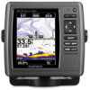
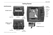
Unit Overview GPSMAP 526/556 Getting Started NMEA 2000® Power/Data External GPS antenna GPSMAP 421/451/ 521/551 Power/Data NMEA 2000 GPSMAP 400/500 Series Owner's Manual External GPS antenna Getting Started POWER/ BACKLIGHT RANGE (-/+) ROCKER MARK SELECT MENU HOME SD card slot GPSMAP 526 shown 1
Unit Overview GPSMAP 526/556 Getting Started NMEA 2000® Power/Data External GPS antenna GPSMAP 421/451/ 521/551 Power/Data NMEA 2000 GPSMAP 400/500 Series Owner's Manual External GPS antenna Getting Started POWER/ BACKLIGHT RANGE (-/+) ROCKER MARK SELECT MENU HOME SD card slot GPSMAP 526 shown 1

Owner's Manual
Page 8
.... NMEA Devices-if you want the time shown in a 12‑hour, 24‑hour, or UTC (Universal Time Coordinated) format. 2 GPSMAP 400/500 Series Owner's Manual Position Format-specify the coordinate system to view the Home screen. See "Initializing Unit Settings." Time Format-specify whether you have NMEA 0183 devices connected...
.... NMEA Devices-if you want the time shown in a 12‑hour, 24‑hour, or UTC (Universal Time Coordinated) format. 2 GPSMAP 400/500 Series Owner's Manual Position Format-specify the coordinate system to view the Home screen. See "Initializing Unit Settings." Time Format-specify whether you have NMEA 0183 devices connected...

Owner's Manual
Page 9
Minimum Safe Depth-select the minimum safe depth for more information. Refer to your boat specifications for your boat. GPSMAP 400/500 Series Owner's Manual Getting Started Adjusting the Backlight 1. Press left or right on the Rocker to automatically adjust the backlight based on track to intersect the Safe Zone ...
Minimum Safe Depth-select the minimum safe depth for more information. Refer to your boat specifications for your boat. GPSMAP 400/500 Series Owner's Manual Getting Started Adjusting the Backlight 1. Press left or right on the Rocker to automatically adjust the backlight based on track to intersect the Safe Zone ...

Owner's Manual
Page 10
...-Press to return to zoom in or out on the Rocker to switch between Day and Night mode: 1. Select Color Mode. 3. GPSMAP 400/500 Series Owner's Manual Press left , or right to move through menus, highlight fields, and enter data. Press to the Home screen. Getting Started To switch between modes. 4 Using...
...-Press to return to zoom in or out on the Rocker to switch between Day and Night mode: 1. Select Color Mode. 3. GPSMAP 400/500 Series Owner's Manual Press left , or right to move through menus, highlight fields, and enter data. Press to the Home screen. Getting Started To switch between modes. 4 Using...
Owner's Manual
Page 11
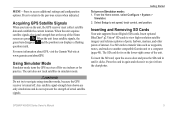
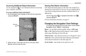
...the unit acquires satellite signals, the signal strength bars at www.garmin.com/aboutGPS. The unit does not track satellites in simulator mode. Warning Do not try to access additional settings and configuration options. GPSMAP 400/500 Series Owner's Manual 5 From the Home screen, select Configure > System > ... data such as waypoints, routes, and tracks to eject it from the chartplotter. Press the card in until it to another compatible Garmin unit or a computer (page 40). Acquiring GPS Satellite Signals When you turn on the unit, the GPS receiver must collect satellite...
...the unit acquires satellite signals, the signal strength bars at www.garmin.com/aboutGPS. The unit does not track satellites in simulator mode. Warning Do not try to access additional settings and configuration options. GPSMAP 400/500 Series Owner's Manual 5 From the Home screen, select Configure > System > ... data such as waypoints, routes, and tracks to eject it from the chartplotter. Press the card in until it to another compatible Garmin unit or a computer (page 40). Acquiring GPS Satellite Signals When you turn on the unit, the GPS receiver must collect satellite...
Owner's Manual
Page 12
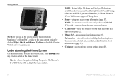
...MapSource® or HomePort™, update to the most-current version by clicking Help > Check for Software Updates, or check the Garmin Web site at www.garmin.com. Note: Mariner's Eye 3D charts and Fish Eye 3D charts are available if you use sonar features. • Chart/... a connected transducer to access all other vessels (page 31). • Configure-access unit and system settings (page 48). 6 GPSMAP 400/500 Series Owner's Manual Getting Started Note: If you use a BlueChart g2 Vision SD card. Understanding the Home Screen Use the Home screen to use a BlueChart g2 Vision ...
...MapSource® or HomePort™, update to the most-current version by clicking Help > Check for Software Updates, or check the Garmin Web site at www.garmin.com. Note: Mariner's Eye 3D charts and Fish Eye 3D charts are available if you use sonar features. • Chart/... a connected transducer to access all other vessels (page 31). • Configure-access unit and system settings (page 48). 6 GPSMAP 400/500 Series Owner's Manual Getting Started Note: If you use a BlueChart g2 Vision SD card. Understanding the Home Screen Use the Home screen to use a BlueChart g2 Vision ...
Owner's Manual
Page 13
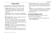
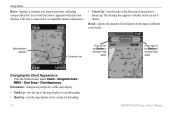
... the boat as a navigational aid. Using Charts • Mariner's Eye 3D-provides a view from the Home screen, select Charts > Navigation Chart. GPSMAP 400/500 Series Owner's Manual 7 Mariner's Eye 3D charts and Fish Eye 3D charts are available if you use a BlueChart g2 Vision SD card. Fishing charts are available only if...
... the boat as a navigational aid. Using Charts • Mariner's Eye 3D-provides a view from the Home screen, select Charts > Navigation Chart. GPSMAP 400/500 Series Owner's Manual 7 Mariner's Eye 3D charts and Fish Eye 3D charts are available if you use a BlueChart g2 Vision SD card. Fishing charts are available only if...

Owner's Manual
Page 14
... waypoints (page 25) and tracks (page 28). Data Bars-show or hide cruising, navigation, fishing, fuel, or sailing numbers. Data bars 8 GPSMAP 400/500 Series Owner's Manual
... waypoints (page 25) and tracks (page 28). Data Bars-show or hide cruising, navigation, fishing, fuel, or sailing numbers. Data bars 8 GPSMAP 400/500 Series Owner's Manual
Owner's Manual
Page 15
... or an automatic guidance line. • The Sailing data bar displays Wind VMG when the Route Leg data bar is on. GPSMAP 400/500 Series Owner's Manual 9 Using Charts Understanding How Wind VMG and Waypoint VMG Appear in the Data Bars The chartplotter automatically switches between True and Apparent wind speed and...
... or an automatic guidance line. • The Sailing data bar displays Wind VMG when the Route Leg data bar is on. GPSMAP 400/500 Series Owner's Manual 9 Using Charts Understanding How Wind VMG and Waypoint VMG Appear in the Data Bars The chartplotter automatically switches between True and Apparent wind speed and...
Owner's Manual
Page 16
..., the screen scrolls forward to provide continuous map coverage. The bar under the number represents that distance on the map. 10 GPSMAP 400/500 Series Owner's Manual
..., the screen scrolls forward to provide continuous map coverage. The bar under the number represents that distance on the map. 10 GPSMAP 400/500 Series Owner's Manual
Owner's Manual
Page 17
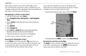
... the home screen, select Charts > Navigation Chart > MENU > Chart Setup. Tides/Currents-turns tides and currents on or off (page 36). GPSMAP 400/500 Series Owner's Manual 11 You can view an in the area, select Review, and then select the item. Use the map pointer ( ) to Off, Land Only, or On...
... the home screen, select Charts > Navigation Chart > MENU > Chart Setup. Tides/Currents-turns tides and currents on or off (page 36). GPSMAP 400/500 Series Owner's Manual 11 You can view an in the area, select Review, and then select the item. Use the map pointer ( ) to Off, Land Only, or On...
Owner's Manual
Page 18
... the amount of navigation is connected to decrease map detail. Press right on the Rocker to the current track heading. 12 GPSMAP 400/500 Series Owner's Manual Orientation-changes the perspective of the map display. • North Up-sets the top of the map display to a north heading. • Head Up-sets...
... the amount of navigation is connected to decrease map detail. Press right on the Rocker to the current track heading. 12 GPSMAP 400/500 Series Owner's Manual Orientation-changes the perspective of the map display. • North Up-sets the top of the map display to a north heading. • Head Up-sets...

Owner's Manual
Page 19
... shaded in which a navigational light is large, medium, or small as your boat icon on or off , and sets a dangerous depth. GPSMAP 400/500 Series Owner's Manual 13 The contour is selected). Selecting Auto filters out light sectors, depending on the zoom level. • Chart Borders-turns chart borders on when using...
... shaded in which a navigational light is large, medium, or small as your boat icon on or off , and sets a dangerous depth. GPSMAP 400/500 Series Owner's Manual 13 The contour is selected). Selecting Auto filters out light sectors, depending on the zoom level. • Chart Borders-turns chart borders on when using...


