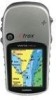
Owner's Manual
Page 20
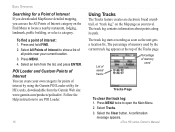
Select an item from the Garmin Web site: www.garmin.com/products/poiloader/. The track log contains information about points along its path. List of saved tracks Percentage of interest: 1. eTrex HC series Owner's Manual Select All Points of Interest to use the All Points of Interest category... used Tracks Page To clear the track log: 1. Press MENU twice to locate a nearby restaurant, lodging, landmark, public building, or select a category. Press and hold FIND. 2. Select the Clear button. To find a point of memory used by using the Garmin POI Loader utility for HCx units,...
Select an item from the Garmin Web site: www.garmin.com/products/poiloader/. The track log contains information about points along its path. List of saved tracks Percentage of interest: 1. eTrex HC series Owner's Manual Select All Points of Interest to use the All Points of Interest category... used Tracks Page To clear the track log: 1. Press MENU twice to locate a nearby restaurant, lodging, landmark, public building, or select a category. Press and hold FIND. 2. Select the Clear button. To find a point of memory used by using the Garmin POI Loader utility for HCx units,...

Owner's Manual
Page 21
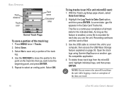
Data card option (HCx units only) • Wrap When Full-the track log records over the oldest data with new data. • Record Method-distance records track points after a specified time has elapsed. Basic Operation • Color-select the color of the microSD card). Press MENU twice > Tracks. 2 Select Save. eTrex HC series Owner's Manual 17 Select...
Data card option (HCx units only) • Wrap When Full-the track log records over the oldest data with new data. • Record Method-distance records track points after a specified time has elapsed. Basic Operation • Color-select the color of the microSD card). Press MENU twice > Tracks. 2 Select Save. eTrex HC series Owner's Manual 17 Select...
Owner's Manual
Page 22
... press ENTER. 5. Highlight the Log Track to an HCx unit microSD card: 1. Open the track logs using Garmin MapSource or another .gpx file-compatible application. 4. Press MENU twice > Tracks. 2. To delete these track logs from the unit while logging a track or corruption of all track data for each day you want to the point on page 38. eTrex HC series Owner's Manual Select...
... press ENTER. 5. Highlight the Log Track to an HCx unit microSD card: 1. Open the track logs using Garmin MapSource or another .gpx file-compatible application. 4. Press MENU twice > Tracks. 2. To delete these track logs from the unit while logging a track or corruption of all track data for each day you want to the point on page 38. eTrex HC series Owner's Manual Select...
Owner's Manual
Page 23
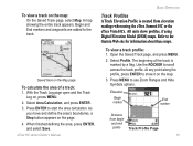
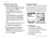
...the ROCKER to the Garmin Web site for information about these maps. At any point along the profile, press ENTER to the track. Saved track on the Map page To calculate the area of the track is created from begin and end points Track Profile Page eTrex HC series Owner's Manual...3. Refer to scroll across the track profile. Select Profile. With the Track Log page open and the Track Log on the map. A map showing the entire track appears. Begin and End markers and waypoints are added to show profiles, if using the eTrex Summit HC or the eTrex Vista HCx. All units show it on ,...
...the ROCKER to the Garmin Web site for information about these maps. At any point along the profile, press ENTER to the track. Saved track on the Map page To calculate the area of the track is created from begin and end points Track Profile Page eTrex HC series Owner's Manual...3. Refer to scroll across the track profile. Select Profile. With the Track Log page open and the Track Log on the map. A map showing the entire track appears. Begin and End markers and waypoints are added to show profiles, if using the eTrex Summit HC or the eTrex Vista HCx. All units show it on ,...
Owner's Manual
Page 24
... of the first turn. Select Use to add it to show the track. With the Saved Tracks page for the track or the Track Log open, select TracBack, to the route. 5. At the first turn, directions to each . The eTrex stores 50 routes with detailed maps only) to route back to the ...using the Routes page, and add waypoints to mark as a user waypoint. 2. Select Follow Road (HCx units with up to start navigating the TracBack. 3. Create or modify a route using MapSource mapping. With a saved track on the map, use the TracBack feature: 1. Move in the direction of the Find groups. ...
... of the first turn. Select Use to add it to show the track. With the Saved Tracks page for the track or the Track Log open, select TracBack, to the route. 5. At the first turn, directions to each . The eTrex stores 50 routes with detailed maps only) to route back to the ...using the Routes page, and add waypoints to mark as a user waypoint. 2. Select Follow Road (HCx units with up to start navigating the TracBack. 3. Create or modify a route using MapSource mapping. With a saved track on the map, use the TracBack feature: 1. Move in the direction of the Find groups. ...

Owner's Manual
Page 37
... plot. Move the Rocker up or down to adjust the vertical distance, and left or right to barometric pressure. To clear the plot, clear the Track Log. Select the type of time or changes over a set distance) apply only to the View Elevation Plot option. Elevation Over Distance plot Pressure Over Time... elevation. Main Pages 2. Adjusting the Zoom Ranges Set the zoom ranges for elevation, distance, or time when you use the Rocker to select Zoom Ranges. 2. eTrex HC series Owner's Manual 33
... plot. Move the Rocker up or down to adjust the vertical distance, and left or right to barometric pressure. To clear the plot, clear the Track Log. Select the type of time or changes over a set distance) apply only to the View Elevation Plot option. Elevation Over Distance plot Pressure Over Time... elevation. Main Pages 2. Adjusting the Zoom Ranges Set the zoom ranges for elevation, distance, or time when you use the Rocker to select Zoom Ranges. 2. eTrex HC series Owner's Manual 33
Owner's Manual
Page 42
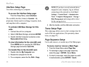
...Note: If you have several network drives mapped to your computer, log on without connecting to a computer. From the Setup Menu select... microSD card: 1. To transfer files to a computer. 2. eTrex HC series Owner's Manual To activate �USB Mass Storage for...Removable Drive listing. Browse the computer for HCx units: 1. To insert a new page, select ...the microSD card: Press Menu prior to exchange waypoint, track, and map data with a computer. To move, ... Menu, select Interface. The available interface format is Garmin-the proprietary format used to opening the USB Mass ...
...Note: If you have several network drives mapped to your computer, log on without connecting to a computer. From the Setup Menu select... microSD card: 1. To transfer files to a computer. 2. eTrex HC series Owner's Manual To activate �USB Mass Storage for...Removable Drive listing. Browse the computer for HCx units: 1. To insert a new page, select ...the microSD card: Press Menu prior to exchange waypoint, track, and map data with a computer. To move, ... Menu, select Interface. The available interface format is Garmin-the proprietary format used to opening the USB Mass ...
Owner's Manual
Page 44
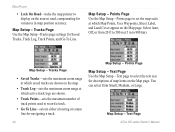
... Page eTrex HC series Owner's Manual You can select from 20 ft to 500 mi (5 m to 800 km). Tracks Page Use the Map Setup -Tracks page settings for variances in map position accuracy. Points page to set the map scale at which active track logs are shown on the map. • Track Log-sets ...the maximum zoom range at which saved tracks are shown. • Track Points-sets the maximum number of track points used to record a track. • Go To Line-selects either a bearing or ...
... Page eTrex HC series Owner's Manual You can select from 20 ft to 500 mi (5 m to 800 km). Tracks Page Use the Map Setup -Tracks page settings for variances in map position accuracy. Points page to set the map scale at which active track logs are shown on the map. • Track Log-sets ...the maximum zoom range at which saved tracks are shown. • Track Points-sets the maximum number of track points used to record a track. • Go To Line-selects either a bearing or ...
Owner's Manual
Page 52
... highway page 36 I initializing 4 installing and removing the microSD card 6 installing batteries 1 installing the lanyard 1 K key functions 3 L log track to data card 17 M main pages 23 map page 24 map data 25 measuring distance 27 orientation 26 setup 39 zoom range 25 mapping databases... 20 deleting 22 off-road transition 22 turn previews 22 S satellite page 23 Sight N'Go 30 specifications 45 status bar 5 T tracks 16 saving a track log 17 setting up a track 17 view a track 19 transferring data to a microSD card 5 Trip & Waypoint Manager 46 turning on the unit 3 U units page 38 W waypoints...
... highway page 36 I initializing 4 installing and removing the microSD card 6 installing batteries 1 installing the lanyard 1 K key functions 3 L log track to data card 17 M main pages 23 map page 24 map data 25 measuring distance 27 orientation 26 setup 39 zoom range 25 mapping databases... 20 deleting 22 off-road transition 22 turn previews 22 S satellite page 23 Sight N'Go 30 specifications 45 status bar 5 T tracks 16 saving a track log 17 setting up a track 17 view a track 19 transferring data to a microSD card 5 Trip & Waypoint Manager 46 turning on the unit 3 U units page 38 W waypoints...


