
Important Safety and Product Information
Page 1
...and thus lead to changes which could affect the accuracy and performance of temperature, direction, distance, location, or altitude. • The GPS altitude calculated by Garmin® or is intended only as in the sun in property damage, serious personal injury, or death. The GPS system is subject to incorrect density... from the actual outside of your surroundings, and to use the altimeter when piloting a pressurized aircraft. • The density altitude function in all times. Aviation Warnings • The indicators represented on the watch is not properly certified.
...and thus lead to changes which could affect the accuracy and performance of temperature, direction, distance, location, or altitude. • The GPS altitude calculated by Garmin® or is intended only as in the sun in property damage, serious personal injury, or death. The GPS system is subject to incorrect density... from the actual outside of your surroundings, and to use the altimeter when piloting a pressurized aircraft. • The density altitude function in all times. Aviation Warnings • The indicators represented on the watch is not properly certified.

Important Safety and Product Information
Page 4
...any country. FOR A FULL UNDERSTANDING OF YOUR RIGHTS, YOU SHOULD CONSULT THE LAWS OF YOUR STATE, COUNTRY OR PROVINCE. Non-aviation products are not labeled as to AC adapters and cables that fail in contravention of the laws of map data. TO THE MAXIMUM... EXTENT PERMITTED BY APPLICABLE LAW, THE WARRANTIES AND REMEDIES CONTAINED IN THIS LIMITED WARRANTY ARE EXCLUSIVE AND IN LIEU OF, AND GARMIN EXPRESSLY DISCLAIMS, ALL OTHER WARRANTIES AND REMEDIES, WHETHER EXPRESS, IMPLIED, STATUTORY, OR OTHERWISE, INCLUDING WITHOUT LIMITATION ANY IMPLIED WARRANTY OF MERCHANTABILITY ...
...any country. FOR A FULL UNDERSTANDING OF YOUR RIGHTS, YOU SHOULD CONSULT THE LAWS OF YOUR STATE, COUNTRY OR PROVINCE. Non-aviation products are not labeled as to AC adapters and cables that fail in contravention of the laws of map data. TO THE MAXIMUM... EXTENT PERMITTED BY APPLICABLE LAW, THE WARRANTIES AND REMEDIES CONTAINED IN THIS LIMITED WARRANTY ARE EXCLUSIVE AND IN LIEU OF, AND GARMIN EXPRESSLY DISCLAIMS, ALL OTHER WARRANTIES AND REMEDIES, WHETHER EXPRESS, IMPLIED, STATUTORY, OR OTHERWISE, INCLUDING WITHOUT LIMITATION ANY IMPLIED WARRANTY OF MERCHANTABILITY ...

Owners Manual
Page 3
... Starting a Flight 10 Viewing Your SpO2 Readings in Flight 11 Navigating to the Nearest Airport.... 12 Navigating to an Aviation Waypoint by Its Identifier 12 Stopping Navigation 12 Enabling Emergency Mode 13 Viewing Waypoint Information......... 13 Horizontal Situation Indicator...........14 Routes...Health Snapshot 23 Recording a Strength Training Activity 23 Recording a HIIT Activity 24 Using an Indoor Trainer 24 Gaming 25 Using the Garmin GameOn™ App 25 Recording a Manual Gaming Activity 25 Climbing Sports 26 Recording an Indoor Climbing Activity 26 Recording a Bouldering...
... Starting a Flight 10 Viewing Your SpO2 Readings in Flight 11 Navigating to the Nearest Airport.... 12 Navigating to an Aviation Waypoint by Its Identifier 12 Stopping Navigation 12 Enabling Emergency Mode 13 Viewing Waypoint Information......... 13 Horizontal Situation Indicator...........14 Routes...Health Snapshot 23 Recording a Strength Training Activity 23 Recording a HIIT Activity 24 Using an Indoor Trainer 24 Gaming 25 Using the Garmin GameOn™ App 25 Recording a Manual Gaming Activity 25 Climbing Sports 26 Recording an Indoor Climbing Activity 26 Recording a Bouldering...

Owners Manual
Page 7
... IQ Features 123 Downloading Connect IQ Features 124 Downloading Connect IQ Features Using Your Computer 124 Garmin Explore 124 Garmin Golf App 124 Connecting to the Garmin Pilot App 124 Updating the Aviation Database..... 125 Syncing Manually with the Aviation Database 125 User Profile 125 Setting Up Your User Profile 125 Gender Settings 125 Viewing...
... IQ Features 123 Downloading Connect IQ Features 124 Downloading Connect IQ Features Using Your Computer 124 Garmin Explore 124 Garmin Golf App 124 Connecting to the Garmin Pilot App 124 Updating the Aviation Database..... 125 Syncing Manually with the Aviation Database 125 User Profile 125 Setting Up Your User Profile 125 Gender Settings 125 Viewing...

Owners Manual
Page 8
...Navigation 135 Courses 135 Creating and Following a Course on Your Device 136 Creating a Round-Trip Course........ 136 Creating a Course on Garmin Connect 136 Sending a Course to Your Device 137 Viewing or Editing Course Details.. 137 Projecting a Waypoint 137 Navigation Settings 137 Customizing...; Bands.......... 145 Metal Watch Band Adjustment.......... 146 Data Management 146 Deleting Files 146 Troubleshooting 146 Product Updates 146 Contacting Garmin Aviation Product Support 146 Getting More Information 146 My device is in the wrong language...147 Is my phone compatible with my...
...Navigation 135 Courses 135 Creating and Following a Course on Your Device 136 Creating a Round-Trip Course........ 136 Creating a Course on Garmin Connect 136 Sending a Course to Your Device 137 Viewing or Editing Course Details.. 137 Projecting a Waypoint 137 Navigation Settings 137 Customizing...; Bands.......... 145 Metal Watch Band Adjustment.......... 146 Data Management 146 Deleting Files 146 Troubleshooting 146 Product Updates 146 Contacting Garmin Aviation Product Support 146 Getting More Information 146 My device is in the wrong language...147 Is my phone compatible with my...

Owners Manual
Page 12
... start or stop an activity. • Hold to navigate to view the controls menu (Controls, page 94). Using the Watch • Hold LIGHT to an aviation waypoint. TIP: You can set multiple alarms. 1 Hold MENU. 2 Select Clocks > ALARMS > Add Alarm. 3 Enter the alarm time. After 10 seconds, the watch face (Customizing...
... start or stop an activity. • Hold to navigate to view the controls menu (Controls, page 94). Using the Watch • Hold LIGHT to an aviation waypoint. TIP: You can set multiple alarms. 1 Hold MENU. 2 Select Clocks > ALARMS > Add Alarm. 3 Enter the alarm time. After 10 seconds, the watch face (Customizing...

Owners Manual
Page 14
... zone for a geographic location. 4 Select a time zone. 5 If necessary, rename the zone. 4 Clocks to search for a time zone by entering the alphanumeric identifier for an aviation waypoint. • Select Use Map to restart the lap timer . Using the Stopwatch 1 From the watch face without resetting the timers, press MENU, and select...
... zone for a geographic location. 4 Select a time zone. 5 If necessary, rename the zone. 4 Clocks to search for a time zone by entering the alphanumeric identifier for an aviation waypoint. • Select Use Map to restart the lap timer . Using the Stopwatch 1 From the watch face without resetting the timers, press MENU, and select...

Owners Manual
Page 15
...and other important information prior to be used for supplemental purposes only. Editing an Alternate Time Zone 1 Hold MENU. 2 Select Clocks > ALT. Aviation Alerts WARNING This watch is not intended to provide primary flight information and is to use this watch as Favorite. • To enter a ... METAR Source. • To set to display on the glance loop, select Set as a primary means of model output statistics, select MOS Source. Aviation alerts on the alert. 7 Select Enable All Alerts to enable or disable all alerts. • To set an alert at a certain altitude, select...
...and other important information prior to be used for supplemental purposes only. Editing an Alternate Time Zone 1 Hold MENU. 2 Select Clocks > ALT. Aviation Alerts WARNING This watch is not intended to provide primary flight information and is to use this watch as Favorite. • To enter a ... METAR Source. • To set to display on the glance loop, select Set as a primary means of model output statistics, select MOS Source. Aviation alerts on the alert. 7 Select Enable All Alerts to enable or disable all alerts. • To set an alert at a certain altitude, select...

Owners Manual
Page 17
... output statistics and meteograms are available for supplemental purposes only. 1 From the watch face, press UP or DOWN to view the aviation weather glance. 2 Press START. 3 Select METAR. Flying 7 Viewing METAR Information 1 From the watch face, press UP or DOWN to view the... select TAF (Viewing TAF Information, page 8). • To view model output statistics, select MOS. • To view meteograms, select Meteogram. Viewing Aviation Weather Information WARNING This watch is not intended to provide primary flight information and is to be used for United States airports only.
... output statistics and meteograms are available for supplemental purposes only. 1 From the watch face, press UP or DOWN to view the aviation weather glance. 2 Press START. 3 Select METAR. Flying 7 Viewing METAR Information 1 From the watch face, press UP or DOWN to view the... select TAF (Viewing TAF Information, page 8). • To view model output statistics, select MOS. • To view meteograms, select Meteogram. Viewing Aviation Weather Information WARNING This watch is not intended to provide primary flight information and is to be used for United States airports only.

Owners Manual
Page 18
Viewing TAF Information 1 From the watch face, press UP or DOWN to view reports for later times. 8 Flying Airport identifier Aviation flight category Age of the data and when the report was issued Time period covered in the report Wind direction, speed, and gusts Height of the base of the lowest clouds and visibility in statute miles Weather conditions 4 Press DOWN to view the aviation weather glance. 2 Press START. 3 Select TAF.
Viewing TAF Information 1 From the watch face, press UP or DOWN to view reports for later times. 8 Flying Airport identifier Aviation flight category Age of the data and when the report was issued Time period covered in the report Wind direction, speed, and gusts Height of the base of the lowest clouds and visibility in statute miles Weather conditions 4 Press DOWN to view the aviation weather glance. 2 Press START. 3 Select TAF.

Owners Manual
Page 19
The radar data is active for your current GPS position, outlined in the Aviation settings to download new data. NOTE: If you are near the border of radar data for 5 minutes. You can view NEXRAD weather radar, you must ... not see all applicable radar data. 2 If necessary, hold DOWN and START to download additional weather radar images based on a direction from your current location (Aviation Settings, page 17). 1 At any time, hold DOWN and START at the same time. Viewing NEXRAD Weather Radar Before you can view the weather radar...
The radar data is active for your current GPS position, outlined in the Aviation settings to download new data. NOTE: If you are near the border of radar data for 5 minutes. You can view NEXRAD weather radar, you must ... not see all applicable radar data. 2 If necessary, hold DOWN and START to download additional weather radar images based on a direction from your current location (Aviation Settings, page 17). 1 At any time, hold DOWN and START at the same time. Viewing NEXRAD Weather Radar Before you can view the weather radar...

Owners Manual
Page 22
... by Its Identifier You can navigate directly to an aviation waypoint by searching for an alphanumeric identifier. 1 Hold . 2 Select Search by Ident.. 3 Enter all or part of matching waypoints appears. 5 Select the waypoint. 6 Press START ...
... by Its Identifier You can navigate directly to an aviation waypoint by searching for an alphanumeric identifier. 1 Hold . 2 Select Search by Ident.. 3 Enter all or part of matching waypoints appears. 5 Select the waypoint. 6 Press START ...

Owners Manual
Page 23
...inReach device. NOTE: You can view information about your location. Viewing Waypoint Information You can use good piloting judgment in the unlikely event of aviation waypoints. 1 Find a waypoint (Finding a Waypoint, page 15). 2 Select an option: NOTE: Options vary by the selected waypoint type... UP or DOWN to scroll through other nearby airports. 3 Press LIGHT to view the airport information. 4 Follow the pointer to the Garmin® International Emergency Response Coordination Center (IERCC) with the selected location, select NEXRAD (Viewing NEXRAD Weather Radar, page 9). • To...
...inReach device. NOTE: You can view information about your location. Viewing Waypoint Information You can use good piloting judgment in the unlikely event of aviation waypoints. 1 Find a waypoint (Finding a Waypoint, page 15). 2 Select an option: NOTE: Options vary by the selected waypoint type... UP or DOWN to scroll through other nearby airports. 3 Press LIGHT to view the airport information. 4 Follow the pointer to the Garmin® International Emergency Response Coordination Center (IERCC) with the selected location, select NEXRAD (Viewing NEXRAD Weather Radar, page 9). • To...

Owners Manual
Page 24
... and distance to the nearest airport. Flight plans are headed toward or away from indicator. Horizontal Situation Indicator WARNING This watch or by using the Garmin Pilot™ app for aviation. Configurable course deviation distance scale. Bearing to the current destination.
... and distance to the nearest airport. Flight plans are headed toward or away from indicator. Horizontal Situation Indicator WARNING This watch or by using the Garmin Pilot™ app for aviation. Configurable course deviation distance scale. Bearing to the current destination.

Owners Manual
Page 27
...improve battery life. You can be used for it on default activities (Creating a Custom Activity, page 46). Activities and Apps 17 Aviation Settings WARNING This watch is not intended to provide primary flight information and is to be used for indoor, outdoor, athletic, and ... Medium option limits downloads to refresh the data. Airport Options: Sets the airport options that appear when searching for aviation weather data. NEXRAD Tiles: Allows you to garmin.com/ataccuracy. Clear Weather Cache: Deletes all or part of NEXRAD data, or display additional NEXRAD data patches based...
...improve battery life. You can be used for it on default activities (Creating a Custom Activity, page 46). Activities and Apps 17 Aviation Settings WARNING This watch is not intended to provide primary flight information and is to be used for indoor, outdoor, athletic, and ... Medium option limits downloads to refresh the data. Airport Options: Sets the airport options that appear when searching for aviation weather data. NEXRAD Tiles: Allows you to garmin.com/ataccuracy. Clear Weather Cache: Deletes all or part of NEXRAD data, or display additional NEXRAD data patches based...

Owners Manual
Page 82
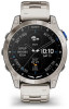
... time at your favorite or nearest airport, including the best runway for landing based on current wind conditions. METAR information from your aircraft. Your D2 Mach 1 watch displays aviation information on the watch. You must still use good piloting judgment in safely operating and landing your favorite or nearest airport (Selecting a Favorite Airport...
... time at your favorite or nearest airport, including the best runway for landing based on current wind conditions. METAR information from your aircraft. Your D2 Mach 1 watch displays aviation information on the watch. You must still use good piloting judgment in safely operating and landing your favorite or nearest airport (Selecting a Favorite Airport...

Owners Manual
Page 84
...calorie information for the last several hours (Body Battery, page 77). Barometer Displays the environmental pressure data based on your D2 Mach 1 watch. Calories Displays your rider type, aerobic endurance, aerobic capacity, and anaerobic capacity (Viewing Cycling Ability, page... your dog's location information when you select a Garmin coach adaptive training plan in additional time zones (Adding Alternate Time Zones, page 4). Aviation weather Displays the current weather conditions and forecasts (Viewing Aviation Weather Infor mation, page 7). Name Description...
...calorie information for the last several hours (Body Battery, page 77). Barometer Displays the environmental pressure data based on your D2 Mach 1 watch. Calories Displays your rider type, aerobic endurance, aerobic capacity, and anaerobic capacity (Viewing Cycling Ability, page... your dog's location information when you select a Garmin coach adaptive training plan in additional time zones (Adding Alternate Time Zones, page 4). Aviation weather Displays the current weather conditions and forecasts (Viewing Aviation Weather Infor mation, page 7). Name Description...

Owners Manual
Page 126
... the preferences from a third-party provider, so you can connect Bluetooth headphones. 116 Music To listen to audio content stored on your phone On a D2 Mach 1 watch . • Third-party provider music • Personal audio content • Music stored on your computer or from the system map settings..., with no additional theme applied. Resort Ski: Sets the map to display data with higher contrast, for better visibility in aviation mode. Hold MENU, and select Map > Map Theme. Symbol Set: Sets the chart symbols in marine mode. Marine: Sets the map ...
... the preferences from a third-party provider, so you can connect Bluetooth headphones. 116 Music To listen to audio content stored on your phone On a D2 Mach 1 watch . • Third-party provider music • Personal audio content • Music stored on your computer or from the system map settings..., with no additional theme applied. Resort Ski: Sets the map to display data with higher contrast, for better visibility in aviation mode. Hold MENU, and select Map > Map Theme. Symbol Set: Sets the chart symbols in marine mode. Marine: Sets the map ...
Owners Manual
Page 135
... selecting your fitness compares with the database at any time. 1 Hold MENU. 2 Select Connectivity > Wi-Fi > Aviation Database Updates. 3 Wait while your watch to update the aviation database. Setting Up Your User Profile You can update your Garmin Connect account. After the initial setup, you can customize the profile settings in to your...
... selecting your fitness compares with the database at any time. 1 Hold MENU. 2 Select Connectivity > Wi-Fi > Aviation Database Updates. 3 Wait while your watch to update the aviation database. Setting Up Your User Profile You can update your Garmin Connect account. After the initial setup, you can customize the profile settings in to your...

Owners Manual
Page 156
... checks for updates when connected to aviationsupport.garmin.com for Garmin devices: • Software updates • Map updates • Course updates • Data uploads to Garmin Connect • Product registration Contacting Garmin Aviation Product Support • Go to Bluetooth or... Wi‑Fi. On your computer, install Garmin Express (www.garmin.com/express). Metal Watch Band Adjustment If your watch ...
... checks for updates when connected to aviationsupport.garmin.com for Garmin devices: • Software updates • Map updates • Course updates • Data uploads to Garmin Connect • Product registration Contacting Garmin Aviation Product Support • Go to Bluetooth or... Wi‑Fi. On your computer, install Garmin Express (www.garmin.com/express). Metal Watch Band Adjustment If your watch ...
