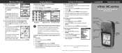
Garmin eTrex Summit HC Support Question
Garmin eTrex Summit HC Support Question
Find answers below for this question about Garmin eTrex Summit HC.Need a Garmin eTrex Summit HC manual? We have 4 online manuals for this item!
Current Answers
Related Garmin eTrex Summit HC Manual Pages
Owner's Manual - Page 3
...eTrex Vista® HCx, eTrex Legend® HCx, eTrex Summit® HC, or eTrex Venture® HC. Decrease the level of this manual that is not universal for all HC...For a complete list of Garmin high-sensitivity GPS and fullfeatured mapping to www.garmin.com/support...feature is discussed in a safe place. Connect to http://buy.garmin.com. eTrex HC series Owner's Manual
In Europe...
Owner's Manual - Page 4
... i Optional Accessories i
Getting Started 1 Installing Batteries and Lanyard 1 Operating the eTrex 2 Key Functions 3 Turning on the eTrex 4 Adjusting the Backlight 4 Initializing the GPS Receiver 4
Basic Operation 7 Creating and Using Waypoints 7 Proximity Waypoints 9 Using the...Software License Agreement 47 Declaration of Conformity 47 Index 48
eTrex HC series Owner's Manual
Owner's Manual - Page 7
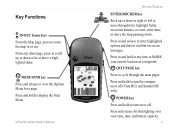
... a page.
Press and hold to turn the compass on or off (Vista HCx and Summit HC only). POWER key
Press and hold to turn on or off . Press and hold to view... fields, on -screen messages. Press in and release to cycle through lists;
eTrex HC series Owner's Manual
Getting Started
ENTER/ROCKER key
Rock up or down or right...any time to MARK your current location as a waypoint.
Owner's Manual - Page 8
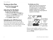
... a clear view of the sky. The number of you facing the sky.
Highlight the appropriate solution, and press ENTER.
eTrex HC series Owner's Manual Press ENTER or QUIT to decrease. 3. While the GPS receiver is searching for the satellite signals, a "Locating Satellites" message is replaced by an "Acquiring Satellites" message until enough signals...
Owner's Manual - Page 9
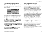
... searching for a microSD™ card (user provided) that can view listings of data transferable is 24 MB for the eTrex Summit HC and Venture HC, for compatible MapSource products and pre-loaded microSD cards.
The eTrex Vista HCx and Legend HCx are equipped with detailed maps from an auxiliary source. With selected MapSource mapping data...
Owner's Manual - Page 11
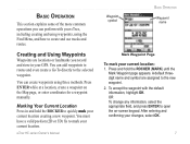
...your current location creating a new waypoint. eTrex HC series Owner's Manual
Waypoint symbol
Basic Operation
Waypoint name
Mark Waypoint Page
To mark your changes, select OK.
Press ...manually. OR To change any information, select the appropriate field, and press ENTER to quickly mark your GPS. Press ENTER while at a location, create a waypoint on -screen keypad. After entering...
Owner's Manual - Page 12
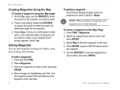
...4. Select the waypoint you want to delete > Delete. eTrex HC series Owner's Manual Select Save. Do you want to ... and open the information page for that point, a "No map information at this point. To edit a waypoint: 1. To move...mark.
2. Basic Operation
Creating Waypoints Using the Map To create a waypoint using the Map page:
1.
Select Waypoints. 3. Press ENTER to place...
Owner's Manual - Page 13
...waypoint you want to begin averaging. 2. eTrex HC series Owner's Manual
Basic Operation
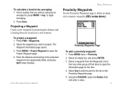
Proximity Waypoints... The
Waypoint Information page opens. 3. Select Use to add the point to define an alarm circle around a waypoint. (HCx version shown...Enter the distance and bearing to open the information page for , press MARK > Avg to project.
Projecting a Waypoint Create a new waypoint by ...
Owner's Manual - Page 14
... data loaded to open the Find Menu. When outside the set radius, a "Leaving Proximity Point" message is pre-set proximity alarm tones: 1. Press and hold the FIND key to the...pointer. Additional icons appear depending on or off: Press MENU twice > Proximity (eTrex HCx and HC units) > Proximity Alarm Tones (eTrex HCx units) and check or uncheck the Proximity Alarms box. Basic Operation
To...
Owner's Manual - Page 15
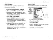
... 1. Use the ROCKER to select the item you want to search for or gone to recently.
eTrex HC series Owner's Manual 11
To find . Select the location item from the Find list and press ... for the type of item you have searched for , or search the entire database by selecting All Points of Interest.
3.
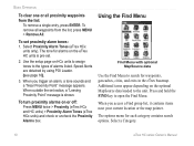
Press and hold FIND to open the Find Menu.
2. The item's information page...
Owner's Manual - Page 16

... Here-return to the Find Menu to search for map items near the item.
12
• Change Reference-point to a new location on the Map page using the pointer.
• Set Proximity-program an alarm to ...See page 44.
• View Hunt and Fish-view Hunt and Fish tables for this item's location. eTrex HC series Owner's Manual See page 20.
• View Sun and Moon-view Sun and Moon tables for ...
Owner's Manual - Page 19
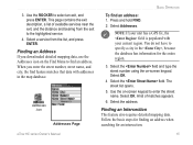
... street name, and city, the find feature matches that data with your unit has a GPS fix, the field is populated with addresses in the , because the database has information for... icon
Addresses Page
Basic Operation
To find an address. Select Addresses. NOTE: If your current region. eTrex HC series Owner's Manual 15 Use the on the Find Menu to the highlighted service.
4. Use the ...
Owner's Manual - Page 21

...records the current track log to the microSD card, in addition to record a large number of track points (depending on the data card are .gpx GPS position data files, and are not used by your unit. Press MENU twice > Tracks. 2.
Using...save the entire track log: 1. Select Setup. Track logs on the capacity of the microSD card). eTrex HC series Owner's Manual 17
To set up a track log: 1.
Owner's Manual - Page 23
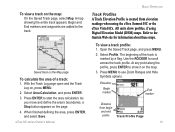
... if using the eTrex Summit HC or the eTrex Vista HCx. Elevation
Begin marker
End marker
Distance from elevation readings when using Digital Elevation Model (DEM) maps. At any point along the
profile, ...the track is created from begin and end
points
Track Profile Page
eTrex HC series Owner's Manual 19 Track Profiles A Track Elevation Profile is marked by a flag.
Open the Saved Track ...
Owner's Manual - Page 28
... shown on the map display.
24
eTrex HC series Owner's Manual
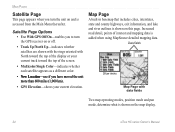
Increased road detail, points of the screen.
• Multicolor/Single Color-indicates whether each satellite appears as a different color.
• New Location-use if you have moved the unit more than 600 miles (1,000 km).
• GPS Elevation-shows your current elevation.
Map...
Owner's Manual - Page 32

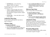
.... Select Switch to enter a speed.
5. The accuracy of the eTrex HC series units use the Vista HCx or Summit HC. Select Heading.
3. Hold the Vista HCx level to conserve batteries....Compass Calibrate the electronic compass outdoors when you first use a GPS data driven compass but only the Vista HCx and Summit HC have an additional electronic compass.)
When you stop (after moving...
Owner's Manual - Page 47
... option for more than...-enter a time limit to switch to the compass. • North Reference-choose from using GPS to using the electronic compass for guidance.
• for the eTrex Vista HCx and Summit HC only. Refer to begin entering
your message in the Welcome Message field.
From the Setup Menu, select Welcome
Message...
Owner's Manual - Page 49
...: 5.6 ounces (159 g) with batteries installed.
Case:
Rugged, fully gasketed, water resistant, IEC-529, IPX7
Temp: 5 to 158°F (-15 to 70° C)*
Altimeter: (Vista HCx/Summit HC only) Accuracy; +/- 10 feet, resolution; 1 ft., user calibrated
Power
Source: Two 1.5 volt AA batteries, 12 V DC Adapter
Cable, or PC/USB Adapter
Battery Life:
Up...
Quick Reference Guide - Page 1
... want to select an item, and press ENTER. Press and hold ENTER.
2. Marking a Waypoint
To mark your changes, select OK, and press ENTER. or its subsidiaries Printed in Taiwan
Quick Start Guide
eTrex® HC series
Vista HCx, Legend HCx, Summit HC, and Venture HC
GPS antenna IN/OUT (Zoom) keys
ENTER/ROCKER key
MENU/FIND key
QUIT...
Quick Reference Guide - Page 2
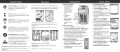
...place. WARNING: See the Important Safety and Product Information sheet in or out. Main Menu
Altimeter Page-tracks elevation and pressure. (Vista HCx and Summit HC...select fields, on the eTrex: 1. Press down a...GPS-aided navigation. Use the Find Menu to your destination. Route Setup
7.
Map Page-shows a detailed map of via points...Press and release QUIT to mark your current location. Using...
Similar Questions

When Navigating A Route Why Doesn't The Device Find Next Way Point
(Posted by grahamfraser 8 years ago)

Garmin Etrex Software 3.10
Where can I download an older version of the etrex software?
Where can I download an older version of the etrex software?
(Posted by Jrtwichell 9 years ago)

Saving Way Points Using Coordinates
How do I save more than 1 way point using coordinates. 2nd entry deletes the 1st.
How do I save more than 1 way point using coordinates. 2nd entry deletes the 1st.
(Posted by pattybackus 10 years ago)

How Do I View My Comments On Way Points On My 655t Garmin
(Posted by Montanamuff 11 years ago)

Can You Enter Your Way Points Directly Into The E10
(Posted by rayandruthpease 12 years ago)