
Garmin eTrex 20 Support Question
Garmin eTrex 20 Support Question
Find answers below for this question about Garmin eTrex 20.Need a Garmin eTrex 20 manual? We have 2 online manuals for this item!
Question posted by adrianr on July 13th, 2014
When Navigating Mt Friens E20 Shows A Compass Mine Does Not Hoe Do I Set This Up
The person who posted this question about this Garmin product did not include a detailed explanation. Please use the "Request More Information" button to the right if more details would help you to answer this question.
Current Answers
Related Garmin eTrex 20 Manual Pages
Owner's Manual - Page 2

Garmin®, the Garmin logo, eTrex®, BlueChart®, and City Navigator® are trademarks of Garmin Ltd. ANT™, ANT+™, BaseCamp™, chirp™, HomePort™, and Thumb Stick™ are trademarks of such changes ...
Owner's Manual - Page 3

Menu 11 Routes 12 Tracks 14
Navigation 16 Navigating to a Destination..........16 Map 16 Compass 17 Elevation Plot 19 Trip Computer 20
eTrex Owner's Manual
Table of Contents
Geocaches 21 Downloading Geocaches 21 Filtering the Geocache List..........21 Navigating to a Geocache............22 Logging the Attempt 22 chirp 23
Applications 24 Sharing Data 24 Setting a Proximity Alarm 24 ...
Owner's Manual - Page 5

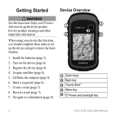
Turn on the device (page 8). 3. Navigate to know the basic features.
1. Calibrate the compass (page 17).
➊ Zoom keys ➋ Back key ➌ Thumb Stick™ ➍ Menu key ➎ /Backlight key
eTrex Owner's Manual
5 Register the device (page 8). 5. Create...the first time, you should complete these tasks to set up the device and get to a destination (page 16). 9.
Owner's Manual - Page 10

Select a waypoint.
3.
Using Sight 'N Go
Sight 'N Go is available on the eTrex 30. Point the device at an object or in the direction, and then navigate to eight samples for the waypoint, waiting at an object in the distance, lock in the direction of a location.
3. Select Start.
5. Enter the distance to ...
Owner's Manual - Page 16

... map.
16
eTrex Owner's Manual
Select Map.
2. The map page opens with your route marked with a magenta line on the map. Navigation
Navigation
You can use the map (page 16) or compass (page 17) to navigate to your destination. Select Go.
Navigating to a Destination
You can navigate to zoom in the device. Navigate using the map or compass.
1. When...
Owner's Manual - Page 17

... navigation is using the automotive profile, the compass displays GPS heading, not magnetic heading. Before you can use an auto mount accessory with the device, you must also purchase and install the mount in the text bar along the top of the screen shows information about the selected location.
• Select a location on the eTrex 20...
Owner's Manual - Page 18

... the distance
18
eTrex Owner's Manual Select Compass.
3.
Follow the on your destination is most useful if you drift from the course. As you are navigating on water or where there are moving.
1. The course line to your original starting point.
Navigating with the Bearing Pointer When navigating to a destination, points to your relationship to...
Owner's Manual - Page 19

Use the course pointer to navigate
to a destination (page 16).
2. Select an option.
eTrex Owner's Manual
19 To customize the elevation plot, see page 34. between dots on the plot. Select Compass. 3.
Details about a Point on the Plot
Select an individual point on the course deviation indicator. Viewing Details about the point appear at...
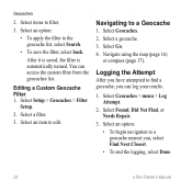
Owner's Manual - Page 22
...select Search.
• To save the filter, select back. Editing a Custom Geocache Filter 1.
Navigating to edit. Logging the Attempt
After you have attempted to a geocache nearest you can access ...2. Select an option: • To begin navigation to find a geocache, you , select Find Next Closest. • To end the logging, select Done.
22
eTrex Owner's Manual After it is saved, the ...
Owner's Manual - Page 23

...When you can find a chirp in a geocache. Select Geocaches > menu > Show
chirp™ Details.
2. If available, select Go to navigate to a geocache (page 22).
For more information about looking for the cache ...a comment, and select Done. Begin navigating to the next stage of the geocache that you are within 33 feet (10 m) of the geocache. eTrex Owner's Manual
23 Select chirp™...
Owner's Manual - Page 29
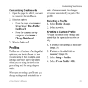
... based on water. Select a profile.
Customize the settings as
necessary (page 28). 3. When you change settings such as data fields or
eTrex Owner's Manual
Customizing Your Device
units of measurement, the changes are saved automatically as part of settings that optimize your settings and data fields for navigating on how you are using a profile and you...
Owner's Manual - Page 30

.../EGNOS (Wide Area Augmentation System/European Geostationary Navigation Overlay Service), or Demo Mode (GPS off .
note: Changing the text language ...Settings
Select Setup > System.
• GPS-sets the GPS to http://www.garmin.com/ aboutGPS/waas.html.
• Language-sets the text language on the device. Note: To adjust the backlight brightness, see page 40.
• Colors (eTrex 20/30)-sets...
Owner's Manual - Page 34

... the map is structured.
• Map Spheroid-shows the coordinate system the device is WGS 84. sets the direction to your destination.
◦◦ Course (CDI)-the course deviation indicator displays your relationship to a course line leading to a destination.
• Compass-switches from an electronic compass to a GPS compass when you to self-calibrate each time...
Owner's Manual - Page 46

... as BirdsEye satellite imagery, Garmin custom maps, Inland Lakes, TOPO, BlueChart g2, and City Navigator maps.
These accessories use optional fitness accessories including a heart rate monitor or a cadence sensor ...+™ wireless technology to send data to the device. Select Search for the eTrex 30. Optional Fitness Accessories Fitness accessories are available at http://buy.garmin.com or...
Owner's Manual - Page 54

...for 31 almanac hunting and fishing 25 sunrise and sunset 25 altimeter calibrating 20 plot type 35 settings 34
ANT+ accessories 46 area calculation 25 automotive mode 31 auto mounts 17... calculator 25 calendar 25 calibrating
altimeter 20 compass 18 caring for the device 42 long-term storage 42 chirp 23 City Navigator maps 17 compass 17 calibrating 18 navigating 18 restore 39 setup options 34 ...
Owner's Manual - Page 55

...
profiles 30 routes 12 waypoints 9
eTrex Owner's Manual
elevation plot 19, 20 barometric altimeter 20 of a track 15
F file types 43 finding
addresses 12 near your location 11 fishing times 25 fitness options 46
G geocaches 21, 35
downloading 21 filter list 21 logging attempt 22 navigating to 22 settings 35 GPS signals 8, 26, 30, 47, 49...
Quick Start Manual - Page 2
... device (page 4).
4. Calibrate the compass (page 5).
6. Create a route (page 7).
8. Turn on the device (page 4).
3. Navigate to know the basic features.
1....set up the device and get to a destination (page 8).
➊
➋
➌
➍
➎
➊ Zoom keys ➋ Back key ➌ Thumb Stick™ ➍ Menu key
➎ Power and backlight key
2
eTrex 20...
Quick Start Manual - Page 5

... the device for geocaching and for navigating on water.
1.
You should calibrate the compass after moving long distances, experiencing temperature changes, or changing the batteries.
1. Select Calibrate Compass > Start.
4.
Select Compass. 2. eTrex 20/30 Quick Start Manual
5 Calibrating the Compass
Notice Calibrate the electronic compass outdoors.
Select menu. 3. can be different...
Quick Start Manual - Page 8

... represents your route marked with the Bearing Pointer The eTrex 30 has a 3-axis, electronic compass.
8
eTrex 20/30 Quick Start Manual Complete one or more or less often. Tip: To customize the map view, select menu > Setup Map, and adjust the settings. Navigate using the map or compass.
1. Using the Map
1. NOTE: Using the Most Often interval...
Quick Start Manual - Page 9

... Windows
eTrex 20/30 Quick Start Manual
computers and as mounted volumes on -screen instructions
to find and download geocaches to your data or settings.
9 Go to a Computer
1.
Connect the USB cable to a USB port on your device to a computer (page 9).
2. Connect your computer.
2. Follow the on Mac computers. Remove the batteries. 2. Begin navigation...
Similar Questions


Mileage To Destination
Can I get mileage to destination to appear on dashboard of my garmin Nuvi 2445lm
Can I get mileage to destination to appear on dashboard of my garmin Nuvi 2445lm
(Posted by beverleyreeve147 9 years ago)


Calibrating Compass
trying to calibrate the compass - I select Compass, then press the menu option. I am not given a Ca...
trying to calibrate the compass - I select Compass, then press the menu option. I am not given a Ca...
(Posted by margaret13356 12 years ago)