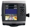
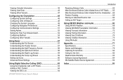
Garmin GPSMAP 541s Support Question
Garmin GPSMAP 541s Support Question
Find answers below for this question about Garmin GPSMAP 541s - Marine GPS Receiver.Need a Garmin GPSMAP 541s manual? We have 8 online manuals for this item!
Question posted by jeffkaley on September 14th, 2012
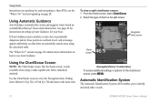
When Using Sonar Where Is The Boat In Reation To The Depth Reading
The sonar screen advances as the boat progresses. There is a depth vaue on top of the screen... WHERE is that depth *just under the boat? a certain number of feet ahead of the boat? At a given angle in relation to the boats location?
Current Answers
Related Garmin GPSMAP 541s Manual Pages
Installation Instructions - Page 3
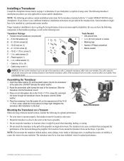
...Number 2 Phillips screwdriver
F
H
• Marine sealant
I - Installing a Transducer
Consult the chartplotter feature matrix on the boat. If you have to be spliced and connected to any part of the boat...E - 10-32 × 1.75 in the path of the propeller on the exposed end of using sonar. Be sure you choose to operate properly, the transducer must be in . H
4.
NOTE: The...
Technical Reference for Garmin NMEA 2000 Products - Page 33

...marine devices, select Config > Factory Defaults. 3.
Select a fluid type. 4. When you troubleshoot the gauge-type setting, if the engine-tilt reading on your display device, consult the documentation provided with your boat... or marine instrument changes with .
1. After the command, enter a whole number between 1 and 253, which each GFL 10 adapter is in the tank with engine number 2....
Technical Reference for Garmin NMEA 2000 Products - Page 35

...Number and Fluid Type Selections Are Not Displayed Depending on the version of software loaded on your boat...: 1.
Use the throttle to indicate the fluid type as defined in neutral. 2. If the fluid-level reading changes with... number if the menu option is not displayed: If your Garmin marine instrument, the specific configuration options may not be displayed on the configuration screens...
Technical Reference for Garmin NMEA 2000 Products - Page 38

... calibrate the water speed if the menu option is stationary; Ensure that the boat is not displayed: To use the GST 10 adapter, you must select the source for Garmin NMEA 2000 ...and Sensor Number Selections Are Not Displayed Depending on the version of software loaded on your Garmin marine instrument, the specific configuration options may not be displayed on the configuration screens. From ...
Owner's Manual - Page 3
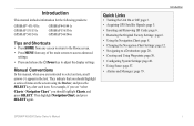
..., when you should highlight a series of the main screens to access advanced settings.
• Press and release the Power key to a Destination: page 28. • Creating and Using Waypoints: page 30. • Configuring System Settings: page 48. • Using Sonar: page 57. • Alarms and Messages: page 79.
GPSMAP 400/500 Series Owner's Manual They indicate...
Owner's Manual - Page 4
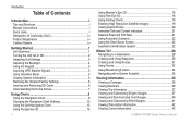
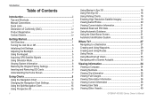
... Settings 12 Using the Split Navigation Chart 15 Using Perspective 3D 15
ii
Using Mariner's Eye 3D 16 Using Fish Eye 3D 18 Using Fishing Charts 19 Enabling High Resolution Satellite Imagery 19 Viewing Aerial Photos 20 Animated Tide and Current Indicators 21 Detailed Road and POI Data 21 Using Automatic Guidance 22 Using the Chart/Sonar Screen 22 Automatic...
Owner's Manual - Page 5
... Understanding the Split Zoom Screen 58 Understanding the Depth Log Screen 59 Understanding the Temp Log Screen 59 Setting Up Sonar 60 Advanced Sonar Settings 61
Using Digital Selective Calling (DSC 63 Using the Chartplotter with a VHF Radio 63 Adding a DSC Contact 64 Viewing the DSC List 64
GPSMAP 400/500 Series Owner's Manual
Introduction
Receiving Distress Calls 64 Man-Overboard...
Owner's Manual - Page 11
... screen. The unit does not track satellites in simulator mode.
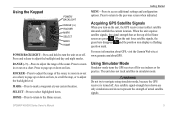
Warning Do not try to navigate using simulator mode, because the GPS receiver is turned off for use indoors or for practice. GPSMAP 400...question mark. Using Simulator Mode
Simulator mode turns the GPS receiver off . ROCKER-Press to adjust the range of the sonar, to zoom in or out on the unit, the GPS receiver must collect ...
Owner's Manual - Page 13
... as a GPSMAP 441s) with a connected transducer to use sonar features.
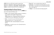
• Chart/Sonar-set up the screen to view a chart and sonar in a split screen (page 22). Getting Started
• Where To?-access navigation features (page 28). • Information-view information including dashboard options,
tides, currents, celestial data, user data, and information about other screens. Note: Mariner...
Owner's Manual - Page 24
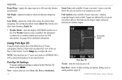
...Depth-adjusts the depth at which red indicates dangerous depths.
Targets are indicated by your transducer on or off to a weather module and you have an "s" series unit (such as fish). GPSMAP 400/500 Series Owner's Manual Use the Range keys to use sonar..., fuel, or sailing numbers (page 9). Note: You must have an XM subscription.) See page 68 for the Fish Eye 3D screen, press MENU. Lane ...
Owner's Manual - Page 28
...
GPSMAP 400/500 Series Owner's Manual
Select the type of chart on how to view the Navigation chart, Fishing chart, Mariner's Eye 3D, or Fish Eye 3D and sonar at the same time.
Using Charts
instructions on page 28. section beginning on searching for the chart/sonar screen, press MENU. To view a split chart/sonar screen: 1. Navigation chart screen
Sonar screen
Using...
Owner's Manual - Page 63
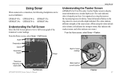
... be used as a ring that starts at the top and progresses clockwise. From the Home screen, select Sonar > Full Screen. Sonar information flashes on a circular depth scale.
The scale indicates what is received at current location
Flasher 57 Depth of the
transducer's sonar readings. It is organized as fishfinders:
GPSMAP 431s GPSMAP 441s GPSMAP 531s GPSMAP 536s GPSMAP 541s GPSMAP...
Owner's Manual - Page 65
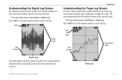
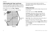
... present depth is received.
From the Home screen, select Sonar > Temp Log. Temp and depth
Time elapsed
Temperature range
Depth Log
The depth appears along the right side, and the time elapsed appears along the bottom.
The current temperature and the depth are using a temperature-capable transducer, the Temp Log screen keeps a graphic log of depth readings over time. Temp Log
GPSMAP...
Owner's Manual - Page 66
... shown.
Select Auto to all sonar screens. Using Sonar
The temperature appears along the right side, and the time elapsed appears along the right side of the screen.
The target depth of each symbol is received. Background sonar information appears, making the distinction between fish and structure easier. Setting Up Sonar
Use the Sonar Setup screen to define and adjust settings...
Owner's Manual - Page 91

...number of engines 39 status alarms 39 viewing 37 Enter Coordinates 30
F
factory settings, restoring 6 fish eye 3D 18
settings 18 fishing chart 19
AIS 27 MARPA 27 fishing information 73
GPSMAP ...
Calibrate Water Speed 55 celestial information 43 Chart/Sonar screen
using 22 Chart Borders 14 chart data 10 charts
detail 13 fish eye 3D 18 fishing 19 mariner's eye 3D 16 navigation 8 settings 12 cleaning ...
Owner's Manual - Page 4
... Chart Settings 12 Using the Split Navigation Chart 15 Using Perspective 3D 15
ii
Using Mariner's Eye 3D 16 Using Fish Eye 3D 18 Using Fishing Charts 19 Enabling High Resolution Satellite Imagery 19 Viewing Aerial Photos 20 Viewing Current-station Information 21 Detailed Road and POI Data 21 Using Automatic Guidance 21 Using the Chart/Sonar Screen 21 Automatic...
Owner's Manual - Page 27
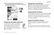
... coastal roads and POIs such as highlighted arrows. Using the Chart/Sonar Screen
Note: The Chart/Sonar screen, like the Sonar screen, is only available when using a sonar-capable unit with the pointer, and select Aerial Photo or Review.
Perspective Overhead
Viewing Current-station Information
If current stations are available in your boat. These detailed icons
show the speed and...
Owner's Manual - Page 56
... chartplotters can be used as fishfinders:
GPSMAP 430s GPSMAP 431s GPSMAP 530s GPSMAP 531s GPSMAP 540s GPSMAP 541s
GPSMAP 440s GPSMAP 441s GPSMAP 535s GPSMAP 536s GPSMAP 545s GPSMAP 546s
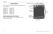
Understanding the Full Screen
Select the Full Screen option to view a full-screen graph of the
transducer's sonar readings. From the Home screen, select Sonar > Full Screen.
Depth Temperature
Speed...
Owner's Manual - Page 58
... sonar screens. If using a temperature-capable transducer, the Temp Log screen keeps a graphic log of the screen.
52
GPSMAP 400/500 Series Owner's Manual Temp and depth
Time elapsed
Temperature range
Temp Log
The temperature appears along the right side, and the time elapsed appears along the right side of temperature readings over time. Setting Up Sonar
Use the Sonar Setup screen...
Owner's Manual - Page 83
... 46 fuel 47 GPS accuracy 46 navigation 45 safe-zone 49 shallow water 46 sonar 46 water temp 46...Sonar screen
using 21 chart data 10 charts
detail 14 fish eye 3D 18 fishing 19 mariner's eye 3D 16 navigation 8 settings 12 cleaning the unit 74 Clear User Data 37 collision alarm 26, 49 colors, hazard 17 Color Scheme 53 Communications 44 Compass 34 compass rose 12 contact information, Garmin iv
GPSMAP...
Similar Questions

Depth Gauge Light Blinks, Depth Reading Is Not Accurate
depth gauge light blinks, depth reading is not accurate
depth gauge light blinks, depth reading is not accurate
(Posted by jshunter 5 years ago)

No Depth Readings On Gpsmap546s
Have cleaned pins on data cable, transducer, both hot wire and ground connection on data cable. Boug...
Have cleaned pins on data cable, transducer, both hot wire and ground connection on data cable. Boug...
(Posted by sue1953bc 7 years ago)
Gps/map 541s Has No Power
I have tring all conection have their is no power
I have tring all conection have their is no power
(Posted by harrypage 9 years ago)

Garmin 541s Depth Flashes
Depth flashes when in 40' deep water then goes to 17' while flashing will go to 137' Doesn't do it a...
Depth flashes when in 40' deep water then goes to 17' while flashing will go to 137' Doesn't do it a...
(Posted by dnilsson360 10 years ago)

541s Marine Gps. Depth Not Reading Out.
Depth has been working since installed. Now blank. Is there an on off control for this that may have...
Depth has been working since installed. Now blank. Is there an on off control for this that may have...
(Posted by therad50 11 years ago)