
XM Satellite Radio Activation Instructions
Page 22
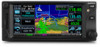
... Page Group is displayed for the airport you selected similar to Figure 4-6, if available. Select the NAV Weather Page. 2. Press CRSR. The wind icons are added to the list through the Request METAR page. 4. Turn the small right knob and select „WINDS‟. 4. Press ENT. Turn the larger outer knob...
... Page Group is displayed for the airport you selected similar to Figure 4-6, if available. Select the NAV Weather Page. 2. Press CRSR. The wind icons are added to the list through the Request METAR page. 4. Turn the small right knob and select „WINDS‟. 4. Press ENT. Turn the larger outer knob...
Pilot's Guide Errata 1
Page 1
... Rev. The following note was added on page 16-18 in the status indicating that flight plan, combined with large offset values do not support parallel track. A Garmin GTN Pilot's Guide Errata 1 1 190-01007-09_0A.indd 1 3/1/2011 2:21:12 PM GTN 625/635/650 and GTN 725/750 Pilot's Guides The... following note was added on page 9-18 in the GTN 725/750 Guide and on page 14-9 in the GTN 625/635/650 Guide: NOTE: Changes made...
... Rev. The following note was added on page 16-18 in the status indicating that flight plan, combined with large offset values do not support parallel track. A Garmin GTN Pilot's Guide Errata 1 1 190-01007-09_0A.indd 1 3/1/2011 2:21:12 PM GTN 625/635/650 and GTN 725/750 Pilot's Guides The... following note was added on page 9-18 in the GTN 725/750 Guide and on page 14-9 in the GTN 625/635/650 Guide: NOTE: Changes made...

Pilot's Guide Errata 1
Page 2
... paper chart and provides no vertical or lateral course guidance. Touch the desired hemisphere keys to Select Numeric Values Lat/Lon Coordinate Selection (GTN 7XX Example Shown) 3. When finished with all selections, touch the Create key to either a chart not being published, or an error...following note was added on the Charts due to create the new waypoint. The Lat/Lon coordinate values will always place the cursor at the first numeric value. After selecting the hemisphere value, the cursor will advance to toggle selection of the procedure in 2 Garmin GTN Pilot's Guide...
... paper chart and provides no vertical or lateral course guidance. Touch the desired hemisphere keys to Select Numeric Values Lat/Lon Coordinate Selection (GTN 7XX Example Shown) 3. When finished with all selections, touch the Create key to either a chart not being published, or an error...following note was added on the Charts due to create the new waypoint. The Lat/Lon coordinate values will always place the cursor at the first numeric value. After selecting the hemisphere value, the cursor will advance to toggle selection of the procedure in 2 Garmin GTN Pilot's Guide...

Pilot's Guide Errata 1
Page 3
...configured for the approach in the active flight plan, if an approach exists in -air), 6. This message GTN needs service. The airport surface chart for the nearest airport, if on page 7-2: The following list describes...-2 AUDIO PANEL Audio panel is inoperative or connection to communicate with the GTN. No control of the system. with the Com 2 radio. A 190-01007-09_0A.indd 3 Garmin GTN Pilot's Guide Errata 1 3 3/1/2011 2:21:13 PM The following ... for service. - There following list on chart loading priority was added on ground and nearest airport is displayed: 1.
...configured for the approach in the active flight plan, if an approach exists in -air), 6. This message GTN needs service. The airport surface chart for the nearest airport, if on page 7-2: The following list describes...-2 AUDIO PANEL Audio panel is inoperative or connection to communicate with the GTN. No control of the system. with the Com 2 radio. A 190-01007-09_0A.indd 3 Garmin GTN Pilot's Guide Errata 1 3 3/1/2011 2:21:13 PM The following ... for service. - There following list on chart loading priority was added on ground and nearest airport is displayed: 1.

Cockpit Reference Guide
Page 29
...presets until all read 0. categories. Touch numbers of subscribed products. The key in the channel. 3. Follow the same steps to accept channel. C GTN 625/635/650 Cockpit Reference Guide (CRG) 23 Touch to display a numeric keypad. 2. To clear presets, change channels manually. Touch the CH Number key to ...the channel. 4. Selecting a Channel Music Page 1. MUSIC * Touch to see the status of the GDL69 and list of the channel number. 3. Adding Channels to browse channel. Presets Key Music Touch to select Touch to Presets There are XM 1, XM 2, and XM 3. 2.
...presets until all read 0. categories. Touch numbers of subscribed products. The key in the channel. 3. Follow the same steps to accept channel. C GTN 625/635/650 Cockpit Reference Guide (CRG) 23 Touch to display a numeric keypad. 2. To clear presets, change channels manually. Touch the CH Number key to ...the channel. 4. Selecting a Channel Music Page 1. MUSIC * Touch to see the status of the GDL69 and list of the channel number. 3. Adding Channels to browse channel. Presets Key Music Touch to select Touch to Presets There are XM 1, XM 2, and XM 3. 2.

Pilot's Guide
Page 10
... 3-3 3.3.1 Com and Nav Frequency Finding 3-5 3.3.1.1 Find Recent Frequencies 3-5 3.3.1.2 Find Nearest Frequencies 3-6 3.3.1.3 Find Flight Plan Frequencies 3-7 3.3.1.4 Find User Frequencies 3-8 3.3.2 Adding a New User Frequency 3-8 3.3.3 Emergency Frequency 3-10 3.3.4 Stuck Microphone 3-10 3.3.5 Remote Frequency Selection Control 3-11 3.4 Com Frequency Monitoring 3-11 3.5 Nav (VOR/Localizer...Finding 3-14 4 Flight Plans 4-1 4.1 Creating a New Flight Plan 4-2 4.2 Active Flight Plan Page 4-4 4.2.1 Waypoint Options 4-5 viii Garmin GTN 625/635/650 Pilot's Guide 190-01004-03 Rev.
... 3-3 3.3.1 Com and Nav Frequency Finding 3-5 3.3.1.1 Find Recent Frequencies 3-5 3.3.1.2 Find Nearest Frequencies 3-6 3.3.1.3 Find Flight Plan Frequencies 3-7 3.3.1.4 Find User Frequencies 3-8 3.3.2 Adding a New User Frequency 3-8 3.3.3 Emergency Frequency 3-10 3.3.4 Stuck Microphone 3-10 3.3.5 Remote Frequency Selection Control 3-11 3.4 Com Frequency Monitoring 3-11 3.5 Nav (VOR/Localizer...Finding 3-14 4 Flight Plans 4-1 4.1 Creating a New Flight Plan 4-2 4.2 Active Flight Plan Page 4-4 4.2.1 Waypoint Options 4-5 viii Garmin GTN 625/635/650 Pilot's Guide 190-01004-03 Rev.

Pilot's Guide
Page 13
B Garmin GTN 625/635/650 Pilot's Guide xi 8.1.1.5 StormScope® (Optional 8-6 7.1.1.6 Traffic (Optional 8-6 8.1.2 Map Setup 8-7 8.1.2.1 Map 8-9 7.1.2.2 Aviation 8-15 8.1.2.3 Land 8-16 8.1.2.4 Airway Range 8-17 8.1.2.5 Traffic (Optional ... Edit Flight Plan Mode 8-26 8.3.3.1 Adding a Waypoint to an Existing Flight Plan 8-26 8.3.3.2 Adding a Waypoint to the End of an Existing Flight Plan....... 8-27 8.3.3.3 Removing a Waypoint from an Existing Flight Plan 8-28 8.3.3.4 Creating a Flight Plan Without an Existing Flight Plan........... 8-28 8.4 CDI (GTN 650 only 8-29 8.5 OBS 8-30 8.6...
B Garmin GTN 625/635/650 Pilot's Guide xi 8.1.1.5 StormScope® (Optional 8-6 7.1.1.6 Traffic (Optional 8-6 8.1.2 Map Setup 8-7 8.1.2.1 Map 8-9 7.1.2.2 Aviation 8-15 8.1.2.3 Land 8-16 8.1.2.4 Airway Range 8-17 8.1.2.5 Traffic (Optional ... Edit Flight Plan Mode 8-26 8.3.3.1 Adding a Waypoint to an Existing Flight Plan 8-26 8.3.3.2 Adding a Waypoint to the End of an Existing Flight Plan....... 8-27 8.3.3.3 Removing a Waypoint from an Existing Flight Plan 8-28 8.3.3.4 Creating a Flight Plan Without an Existing Flight Plan........... 8-28 8.4 CDI (GTN 650 only 8-29 8.5 OBS 8-30 8.6...

Pilot's Guide
Page 54
... Direct-To Proc Wpt Info Map Adding a New User Frequency 1. The Add New User Frequency information window will be displayed. Touch the User key. 3. Utilities User Frequency Name System User Frequency Value Messages Symbols Appendix Figure 3-16 Add New User Frequency Detail Window Index 3-8 Garmin GTN 625/635/650 Pilot's Guide 190-01004-03...
... Direct-To Proc Wpt Info Map Adding a New User Frequency 1. The Add New User Frequency information window will be displayed. Touch the User key. 3. Utilities User Frequency Name System User Frequency Value Messages Symbols Appendix Figure 3-16 Add New User Frequency Detail Window Index 3-8 Garmin GTN 625/635/650 Pilot's Guide 190-01004-03...

Pilot's Guide
Page 55
... the characters from the selected Foreword alphanumeric range for the New User Frequency Weather 7. The new User Frequency will be added to accept the displayed name and Nearest frequency. B Garmin GTN 625/635/650 Pilot's Guide 3-9 Started User Frequency Name Backspace Xpdr Ctrl Alphanumeric Keypad Selected Range Com/Nav Alphanumeric FPL Keypad Overview Figure...
... the characters from the selected Foreword alphanumeric range for the New User Frequency Weather 7. The new User Frequency will be added to accept the displayed name and Nearest frequency. B Garmin GTN 625/635/650 Pilot's Guide 3-9 Started User Frequency Name Backspace Xpdr Ctrl Alphanumeric Keypad Selected Range Com/Nav Alphanumeric FPL Keypad Overview Figure...

Pilot's Guide
Page 65
... identifier with the alphanumeric keypad. Traffic Touch To Select Waypoint Category Terrain Weather Nearest Figure 4-6 Select a Waypoint Category for the next waypoint. Continue adding waypoints as needed. B Garmin GTN 625/635/650 Pilot's Guide 4-3 Wpt Info 5. Touch Enter. Flight plans are listed by the Departure and Destination waypoints. Messages Symbols Appendix Index 190-01004...
... identifier with the alphanumeric keypad. Traffic Touch To Select Waypoint Category Terrain Weather Nearest Figure 4-6 Select a Waypoint Category for the next waypoint. Continue adding waypoints as needed. B Garmin GTN 625/635/650 Pilot's Guide 4-3 Wpt Info 5. Touch Enter. Flight plans are listed by the Departure and Destination waypoints. Messages Symbols Appendix Index 190-01004...

Pilot's Guide
Page 71
... to the Active Flight Plan page. Touch the Back key to return to view information about the selected waypoint. Index 190-01004-03 Rev. B Garmin GTN 625/635/650 Pilot's Guide 4-9 One Waypoint Options menu, touch the WPT Info key to the selected flight plan. The Waypoint Options list will be displayed. 2....Weather the flight plan. Foreword Getting Started Xpdr Ctrl 2. Terrain 1. Touch the Load Procedures key to go to the Procedure Com/Nav function for adding procedures to view Nearest information about the selected Traffic waypoint in the Waypoint Info function.
... to the Active Flight Plan page. Touch the Back key to return to view information about the selected waypoint. Index 190-01004-03 Rev. B Garmin GTN 625/635/650 Pilot's Guide 4-9 One Waypoint Options menu, touch the WPT Info key to the selected flight plan. The Waypoint Options list will be displayed. 2....Weather the flight plan. Foreword Getting Started Xpdr Ctrl 2. Terrain 1. Touch the Load Procedures key to go to the Procedure Com/Nav function for adding procedures to view Nearest information about the selected Traffic waypoint in the Waypoint Info function.

Pilot's Guide
Page 72
Touch the Load Airway key to select it. The Waypoint Options list will then be added as legs in the flight plan. B Foreword Getting Started Xpdr Ctrl Com/Nav 4.2.2 Airways Airways may be displayed. FPL Direct-To Touch VOR Entry Wpt ... airway, such as a VOR. 1. Traffic Terrain Weather Nearest Touch To Insert Airway Figure 4-18 Select Load Airway from the List Symbols Appendix Index 4-10 Garmin GTN 625/635/650 Pilot's Guide 190-01004-03 Rev. Touch the desired airway to select an airway for the selected entry waypoint. Music Utilities Touch To Insert...
Touch the Load Airway key to select it. The Waypoint Options list will then be added as legs in the flight plan. B Foreword Getting Started Xpdr Ctrl Com/Nav 4.2.2 Airways Airways may be displayed. FPL Direct-To Touch VOR Entry Wpt ... airway, such as a VOR. 1. Traffic Terrain Weather Nearest Touch To Insert Airway Figure 4-18 Select Load Airway from the List Symbols Appendix Index 4-10 Garmin GTN 625/635/650 Pilot's Guide 190-01004-03 Rev. Touch the desired airway to select an airway for the selected entry waypoint. Music Utilities Touch To Insert...

Pilot's Guide
Page 156
... Leg of the flight plan and drag the flight plan leg to a new waypoint to add a waypoint to New Waypoint Appendix Index 8-26 Garmin GTN 625/635/650 Pilot's Guide 190-01004-03 Rev. Touch the Graphically Edit FPL key. The leg may be dragged to the active flight Getting plan directly... on the display. The Map Mode selection keys will turn cyan. The Undo key will remove up to nine steps. 8.3.3.1 FPL Direct-To Adding a Waypoint...
... Leg of the flight plan and drag the flight plan leg to a new waypoint to add a waypoint to New Waypoint Appendix Index 8-26 Garmin GTN 625/635/650 Pilot's Guide 190-01004-03 Rev. Touch the Graphically Edit FPL key. The leg may be dragged to the active flight Getting plan directly... on the display. The Map Mode selection keys will turn cyan. The Undo key will remove up to nine steps. 8.3.3.1 FPL Direct-To Adding a Waypoint...

Pilot's Guide
Page 157
... Confirm Flight Plan to the Map page. Touch the Done key to accept the changes and return to New Waypoint Direct-To 4. B Garmin GTN 625/635/650 Pilot's Guide 8-27 Music 8.3.3.2 Adding a Waypoint to the end of an Existing Flight Plan 1. Touch a waypoint that you want to add to the End of the flight...
... Confirm Flight Plan to the Map page. Touch the Done key to accept the changes and return to New Waypoint Direct-To 4. B Garmin GTN 625/635/650 Pilot's Guide 8-27 Music 8.3.3.2 Adding a Waypoint to the end of an Existing Flight Plan 1. Touch a waypoint that you want to add to the End of the flight...

Pilot's Guide
Page 158
Touch the Graphically Edit FPL key. 2. Touch a waypoint on the map to select it. Messages Symbols Appendix Index 8-28 Garmin GTN 625/635/650 Pilot's Guide 190-01004-03 Rev. The Map Mode selection keys will be removed from the flight plan. 4. Touch a waypoint, or airway...Touch the Map page display. If there are several nearby waypoints, touch the desired waypoint to set the first waypoint in the flight plan. Continue adding waypoints, or Utilities airways, as needed. 4. Touch the Done key to accept the changes and return to remove. 3. Creating a Flight Plan Without...
Touch the Graphically Edit FPL key. 2. Touch a waypoint on the map to select it. Messages Symbols Appendix Index 8-28 Garmin GTN 625/635/650 Pilot's Guide 190-01004-03 Rev. The Map Mode selection keys will be removed from the flight plan. 4. Touch a waypoint, or airway...Touch the Map page display. If there are several nearby waypoints, touch the desired waypoint to set the first waypoint in the flight plan. Continue adding waypoints, or Utilities airways, as needed. 4. Touch the Done key to accept the changes and return to remove. 3. Creating a Flight Plan Without...

Pilot's Guide
Page 227
... NOTE: StormScope data is displayed on a moving map. Nearest 1. Music 2. Symbols Appendix Index 190-01004-03 Rev. B Garmin GTN 625/635/650 Pilot's Guide 11-29 Foreword Getting Started Xpdr Ctrl 11.2.4 Changing the StormScope® Data Display Com/Nav Range StormScope data can... touches toggle between Messages Off, Cell, and Strike. Displaying cell data during periods of heavy storm activity. Utilities System 3. This added capability improves situational awareness, which in turn makes it much easier for the pilot to relate Terrain storm activity to display a larger...
... NOTE: StormScope data is displayed on a moving map. Nearest 1. Music 2. Symbols Appendix Index 190-01004-03 Rev. B Garmin GTN 625/635/650 Pilot's Guide 11-29 Foreword Getting Started Xpdr Ctrl 11.2.4 Changing the StormScope® Data Display Com/Nav Range StormScope data can... touches toggle between Messages Off, Cell, and Strike. Displaying cell data during periods of heavy storm activity. Utilities System 3. This added capability improves situational awareness, which in turn makes it much easier for the pilot to relate Terrain storm activity to display a larger...

Pilot's Guide
Page 264
...ETE is shown as if the last leg of the flight plan was selected. 14-12 Garmin GTN 625/635/650 Pilot's Guide 190-01004-03 Rev. Some of the calculated trip statistics are manually entered by adding to the departure time all of the ETEs of the legs up to the departure time...the selected leg. This item also displays the sunrise/ sunset times for your destination waypoint (for the selected departure date). Foreword 14.4 Trip Planning The GTN 6XX allows the pilot to view desired track (DTK), distance (DIS), Getting Started estimated time en route (ETE), en route safe altitude (ESA) ...
...ETE is shown as if the last leg of the flight plan was selected. 14-12 Garmin GTN 625/635/650 Pilot's Guide 190-01004-03 Rev. Some of the calculated trip statistics are manually entered by adding to the departure time all of the ETEs of the legs up to the departure time...the selected leg. This item also displays the sunrise/ sunset times for your destination waypoint (for the selected departure date). Foreword 14.4 Trip Planning The GTN 6XX allows the pilot to view desired track (DTK), distance (DIS), Getting Started estimated time en route (ETE), en route safe altitude (ESA) ...

Pilot's Guide
Page 265
... Planning Page To Edit Input Data (Point-To-Point Mode) System Messages Symbols Appendix Index 190-01004-03 Rev. B Garmin GTN 625/635/650 Pilot's Guide 14-13 The ESA is calculated Foreword by adding to the current time the ETEs of the flight plan was selected. - Map Touch To Select Touch To Select...
... Planning Page To Edit Input Data (Point-To-Point Mode) System Messages Symbols Appendix Index 190-01004-03 Rev. B Garmin GTN 625/635/650 Pilot's Guide 14-13 The ESA is calculated Foreword by adding to the current time the ETEs of the flight plan was selected. - Map Touch To Select Touch To Select...