Pilots Guide
Page 4
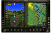
...independently verify the accuracy of functional integrity. Sec 5 & Alerts Annun. Sec 6 Symbols Sec 7 Appendix A Glossary Sec 8 Index Appendix B ii Garmin G600 Pilot's Guide 190-00601-02 Rev. However, the pilot must recognize that the information remains current. Although unlikely, it may be possible for erroneous ...information available in nature and should never be used as the sole source of the pilot to be used in the G600 system must be updated regularly in aircraft. GPS altitude should not be relied upon the use in aircraft. WARNING: Do not use outdated ...
...independently verify the accuracy of functional integrity. Sec 5 & Alerts Annun. Sec 6 Symbols Sec 7 Appendix A Glossary Sec 8 Index Appendix B ii Garmin G600 Pilot's Guide 190-00601-02 Rev. However, the pilot must recognize that the information remains current. Although unlikely, it may be possible for erroneous ...information available in nature and should never be used as the sole source of the pilot to be used in the G600 system must be updated regularly in aircraft. GPS altitude should not be relied upon the use in aircraft. WARNING: Do not use outdated ...

Pilots Guide
Page 7
B Garmin G600 Pilot's Guide v Foreword Sec 1 System Part Number 190-00601-02 Record of Revisions Revision Date Page Range Description A 6/10/08 All Production release B 7/8/08 Update information Sec 2 PFD Sec 3 MFD Sec 4 Hazard Avoidance Features Sec 5 Additional Sec 6 Annun. & Alerts Sec 7 Symbols Sec 8 Glossary Appendix A Appendix B Index 190-00601-02 Rev.
B Garmin G600 Pilot's Guide v Foreword Sec 1 System Part Number 190-00601-02 Record of Revisions Revision Date Page Range Description A 6/10/08 All Production release B 7/8/08 Update information Sec 2 PFD Sec 3 MFD Sec 4 Hazard Avoidance Features Sec 5 Additional Sec 6 Annun. & Alerts Sec 7 Symbols Sec 8 Glossary Appendix A Appendix B Index 190-00601-02 Rev.

Pilots Guide
Page 14
B Sec 1 System Foreword Appendix A A-1 SD Card Use and Databases A-1 Jeppesen Databases A-1 Updating the Jeppesen navigation database A-1 Garmin Databases A-2 Updating Garmin databases A-3 Index...B-1 PFD Sec 2 MFD Sec 3 Features Avoidance Hazard Sec 4 Additional Sec 5 & Alerts Annun. Sec 6 Symbols Sec 7 Appendix A Glossary Sec 8 Index Appendix B xii Garmin G600 Pilot's Guide 190-00601-02 Rev.
B Sec 1 System Foreword Appendix A A-1 SD Card Use and Databases A-1 Jeppesen Databases A-1 Updating the Jeppesen navigation database A-1 Garmin Databases A-2 Updating Garmin databases A-3 Index...B-1 PFD Sec 2 MFD Sec 3 Features Avoidance Hazard Sec 4 Additional Sec 5 & Alerts Annun. Sec 6 Symbols Sec 7 Appendix A Glossary Sec 8 Index Appendix B xii Garmin G600 Pilot's Guide 190-00601-02 Rev.

Pilots Guide
Page 18
... 7 Figure 1-4 GRS 77 AHRS The IGRF (International Geomagnetic Reference Field) model is contained in the GRS 77. Figure 1-5 GMU 44 Magnetometer 1-4 Garmin G600 Pilot's Guide 190-00601-02 Rev. System Sec 1 PFD Sec 2 MFD Sec 3 Features Avoidance Hazard Sec 4 Additional Sec 5 & Alerts Annun.... B Appendix A Glossary Sec 8 Index Appendix B Data is only updated once every five years. Foreword 1.1.4 GRS 77 The GRS 77 is sent using a RS-485 digital interface. The unit contains advanced tilt ...
... 7 Figure 1-4 GRS 77 AHRS The IGRF (International Geomagnetic Reference Field) model is contained in the GRS 77. Figure 1-5 GMU 44 Magnetometer 1-4 Garmin G600 Pilot's Guide 190-00601-02 Rev. System Sec 1 PFD Sec 2 MFD Sec 3 Features Avoidance Hazard Sec 4 Additional Sec 5 & Alerts Annun.... B Appendix A Glossary Sec 8 Index Appendix B Data is only updated once every five years. Foreword 1.1.4 GRS 77 The GRS 77 is sent using a RS-485 digital interface. The unit contains advanced tilt ...

Pilots Guide
Page 22
...Digital (SD) cards to output valid attitude information; NOTE: Refer to keep the aircraft on updating the aviation database. Sec 6 Symbols Sec 7 Appendix A Glossary Sec 8 Index Appendix B 1-8 Garmin G600 Pilot's Guide 190-00601-02 Rev. Other database cards are normally located in the SD card ...slot (the front of the card should be used to A-1 for database updates and then removed. NOTE: Ensure the GDU 620 is ...
...Digital (SD) cards to output valid attitude information; NOTE: Refer to keep the aircraft on updating the aviation database. Sec 6 Symbols Sec 7 Appendix A Glossary Sec 8 Index Appendix B 1-8 Garmin G600 Pilot's Guide 190-00601-02 Rev. Other database cards are normally located in the SD card ...slot (the front of the card should be used to A-1 for database updates and then removed. NOTE: Ensure the GDU 620 is ...
Pilots Guide
Page 27
... momentarily illuminated on and continuous built-in test features that no databases have expired), the pilot is only updated once every five years. The G600 System is part of the Navigation Database. The IGRF model is integrated with the aircraft electrical system and ...and version • Aviation database name, version, and effective dates Current database information includes valid operating dates, cycle number, and database type. B Garmin G600 Pilot's Guide 1-13 Sec 7 Symbols Sec 8 Glossary Appendix A Appendix B Index When the MFD powers up , the IGRF models in the GRS...
... momentarily illuminated on and continuous built-in test features that no databases have expired), the pilot is only updated once every five years. The G600 System is part of the Navigation Database. The IGRF model is integrated with the aircraft electrical system and ...and version • Aviation database name, version, and effective dates Current database information includes valid operating dates, cycle number, and database type. B Garmin G600 Pilot's Guide 1-13 Sec 7 Symbols Sec 8 Glossary Appendix A Appendix B Index When the MFD powers up , the IGRF models in the GRS...
Pilots Guide
Page 28
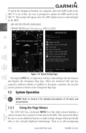
...dedicated MENU key that when pressed displays a context-sensitive list of options for detailed descriptions of all -encompassing 1-14 Garmin G600 Pilot's Guide 190-00601-02 Rev. UPDATE FROM yyyy TO yyyy (e.g. 2005 to the currently displayed window/page. When the interfaced GPS unit has acquired a ...sufficient number of satellites to determine a position, the aircraft's current position is shown on the MFD. GRS MV DB UPDATE AVAILABLE. Sec 6 Symbols Sec 7 Appendix A Glossary Sec 8 Figure 1-14 System Startup Pages Pressing the ENT key (or right-most soft ...
...dedicated MENU key that when pressed displays a context-sensitive list of options for detailed descriptions of all -encompassing 1-14 Garmin G600 Pilot's Guide 190-00601-02 Rev. UPDATE FROM yyyy TO yyyy (e.g. 2005 to the currently displayed window/page. When the interfaced GPS unit has acquired a ...sufficient number of satellites to determine a position, the aircraft's current position is shown on the MFD. GRS MV DB UPDATE AVAILABLE. Sec 6 Symbols Sec 7 Appendix A Glossary Sec 8 Figure 1-14 System Startup Pages Pressing the ENT key (or right-most soft ...

Pilots Guide
Page 141
It is updated every five seconds. TIS receives traffic information from the basemap. Aircraft orientation on the ground, TIS automatically enters Standby Mode. The traffic mode is within a 7.5-... invisible to display traffic information. Aircraft without altitude separation data or climb descent indication. The GDU 620 displays up unless there is no valid heading. B Garmin G600 Pilot's Guide 4-15 When the aircraft is on this map is always heading up to eight traffic targets within the service volume of a TIS-capable...
It is updated every five seconds. TIS receives traffic information from the basemap. Aircraft orientation on the ground, TIS automatically enters Standby Mode. The traffic mode is within a 7.5-... invisible to display traffic information. Aircraft without altitude separation data or climb descent indication. The GDU 620 displays up unless there is no valid heading. B Garmin G600 Pilot's Guide 4-15 When the aircraft is on this map is always heading up to eight traffic targets within the service volume of a TIS-capable...
Pilots Guide
Page 153
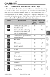
... signals that are defined and controlled by the Data Link Receiver. It does not represent the rate at which weather data is updated or new content is refreshed at intervals that may or may not contain new weather data. Symbol Weather Product NEXRAD (NEXRAD and...County Warnings 60 5 Cyclone Warnings 60 12 Sec 6 Annun. & Alerts Sec 7 Symbols Sec 8 Glossary Appendix A Appendix B Index 190-00601-02 Rev. B Garmin G600 Pilot's Guide 4-27 Weather data is received by XM Satellite Radio and its data vendors. Foreword Sec 1 System Sec 2 PFD Sec 3 MFD Sec 4 Hazard...
... signals that are defined and controlled by the Data Link Receiver. It does not represent the rate at which weather data is updated or new content is refreshed at intervals that may or may not contain new weather data. Symbol Weather Product NEXRAD (NEXRAD and...County Warnings 60 5 Cyclone Warnings 60 12 Sec 6 Annun. & Alerts Sec 7 Symbols Sec 8 Glossary Appendix A Appendix B Index 190-00601-02 Rev. B Garmin G600 Pilot's Guide 4-27 Weather data is received by XM Satellite Radio and its data vendors. Foreword Sec 1 System Sec 2 PFD Sec 3 MFD Sec 4 Hazard...
Pilots Guide
Page 167
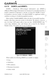
... XM Weather - A Convective SIGMET is every 12 minutes. When enabled, SIGMET/AIRMETs advise the pilot of importance to all aircraft. The update rate is issued for hazardous convective weather. B Garmin G600 Pilot's Guide 4-41 Appendix B Index AIRMETs When enabled, the following AIRMETs are broadcast for potentially hazardous weather considered of potentially hazardous weather...
... XM Weather - A Convective SIGMET is every 12 minutes. When enabled, SIGMET/AIRMETs advise the pilot of importance to all aircraft. The update rate is issued for hazardous convective weather. B Garmin G600 Pilot's Guide 4-41 Appendix B Index AIRMETs When enabled, the following AIRMETs are broadcast for potentially hazardous weather considered of potentially hazardous weather...

Pilots Guide
Page 169
... - METAR (METeorological Aerodrome Report), known as colored flags at airports that provide them. METARs are considered current. METARs are updated hourly and are shown as an Aviation Routine Weather Report, is the standard format for METARs is given in hectopascals (hPa...METARs typically contain information about the temperature, dew point, wind, precipitation, cloud cover, cloud heights, visibility, and barometric pressure. B Garmin G600 Pilot's Guide 4-43 Index NOTE: METAR information is reported in inches of mercury (in Celsius. They can also contain information on...
... - METAR (METeorological Aerodrome Report), known as colored flags at airports that provide them. METARs are considered current. METARs are updated hourly and are shown as an Aviation Routine Weather Report, is the standard format for METARs is given in hectopascals (hPa...METARs typically contain information about the temperature, dew point, wind, precipitation, cloud cover, cloud heights, visibility, and barometric pressure. B Garmin G600 Pilot's Guide 4-43 Index NOTE: METAR information is reported in inches of mercury (in Celsius. They can also contain information on...

Pilots Guide
Page 174
... at the next update. Figure 4-37 XM Weather - New data appears at which the Freezing Level is out of date and has been removed from the display. Freezing Levels MFD Sec 3 Features Avoidance Hazard Sec 4 Additional Sec 5 & Alerts Annun. B Sec 6 Symbols Sec 7 Appendix A Glossary Sec 8 Index Appendix B 4-48 Garmin G600 Pilot's Guide 190...
... at the next update. Figure 4-37 XM Weather - New data appears at which the Freezing Level is out of date and has been removed from the display. Freezing Levels MFD Sec 3 Features Avoidance Hazard Sec 4 Additional Sec 5 & Alerts Annun. B Sec 6 Symbols Sec 7 Appendix A Glossary Sec 8 Index Appendix B 4-48 Garmin G600 Pilot's Guide 190...

Pilots Guide
Page 189
GPS satellite data is valid and within current cycle. Check database cycle number for a ChartView database. B Garmin G600 Pilot's Guide 5-9 Contact Jeppesen for effectivity. ChartView database is within 1 week after expiration date, but no longer available... 3 MFD Sec 4 Hazard Avoidance Features System is configured for ChartView but still within the 70 day viewing period. System time is installed for update. System is verifying chart database when new cycle is not available. Table 5-1 Power-up Page Annunciations and Definitions Sec 5 Additional Sec 6 Annun...
GPS satellite data is valid and within current cycle. Check database cycle number for a ChartView database. B Garmin G600 Pilot's Guide 5-9 Contact Jeppesen for effectivity. ChartView database is within 1 week after expiration date, but no longer available... 3 MFD Sec 4 Hazard Avoidance Features System is configured for ChartView but still within the 70 day viewing period. System time is installed for update. System is verifying chart database when new cycle is not available. Table 5-1 Power-up Page Annunciations and Definitions Sec 5 Additional Sec 6 Annun...
Pilots Guide
Page 191
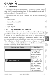
...DP) • Approaches • Airport Diagrams 5.3.1 Cycle Number and Revision FliteCharts data is available from the cycle expiration date to Updating Garmin Databases in color for FliteCharts. When turning on the GDU 620, the Power-up Page Display Definition Blank Line. These indications are... upon reaching the disables date. System is installed. Refer to the disables date. B Garmin G600 Pilot's Guide 5-11 FliteCharts is not configured for applicable charts. G600 system is disabled 180 days after the expiration date and are still viewable during a period...
...DP) • Approaches • Airport Diagrams 5.3.1 Cycle Number and Revision FliteCharts data is available from the cycle expiration date to Updating Garmin Databases in color for FliteCharts. When turning on the GDU 620, the Power-up Page Display Definition Blank Line. These indications are... upon reaching the disables date. System is installed. Refer to the disables date. B Garmin G600 Pilot's Guide 5-11 FliteCharts is not configured for applicable charts. G600 system is disabled 180 days after the expiration date and are still viewable during a period...
Pilots Guide
Page 210
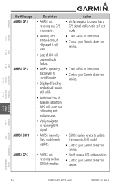
B Sec 5 & Alerts Annun. Sec 6 Symbols Sec 7 Appendix A Glossary Sec 8 Index Appendix B 6-2 Garmin G600 Pilot's Guide 190-00601-02 Rev. Foreword System Sec 1 PFD Sec 2 MFD Sec 3 Features Avoidance Hazard Sec 4 Additional Alert ... of heading and attitude data. • Verify navigator is receiving GPS signal. • AHRS1 magneticfield model needs update. • G600 requires service to update the magnetic field model. • Contact your Garmin dealer for service. • AHRS1 not receiving backup GPS information. • Verify second GPS unit operation. &#...
B Sec 5 & Alerts Annun. Sec 6 Symbols Sec 7 Appendix A Glossary Sec 8 Index Appendix B 6-2 Garmin G600 Pilot's Guide 190-00601-02 Rev. Foreword System Sec 1 PFD Sec 2 MFD Sec 3 Features Avoidance Hazard Sec 4 Additional Alert ... of heading and attitude data. • Verify navigator is receiving GPS signal. • AHRS1 magneticfield model needs update. • G600 requires service to update the magnetic field model. • Contact your Garmin dealer for service. • AHRS1 not receiving backup GPS information. • Verify second GPS unit operation. &#...

Pilots Guide
Page 231
...Garmin G600 Pilot's Guide A-1 For basic flight operations, SD cards are provided by Garmin and may be updated (label of data. Updating the Jeppesen navigation database 1) With the G600 System OFF, insert the SD card containing the navigation database update into the unit. com) for navigation database updates and update...store various types of SD card should face up). 2) Turn the G600 System ON. 3) Verify the correct update cycle is provided directly from the Garmin website "fly.garmin.com" onto a Garmin provided Supplemental Datacard. Contact Jeppesen (www.jeppesen. Foreword Sec 1 ...
...Garmin G600 Pilot's Guide A-1 For basic flight operations, SD cards are provided by Garmin and may be updated (label of data. Updating the Jeppesen navigation database 1) With the G600 System OFF, insert the SD card containing the navigation database update into the unit. com) for navigation database updates and update...store various types of SD card should face up). 2) Turn the G600 System ON. 3) Verify the correct update cycle is provided directly from the Garmin website "fly.garmin.com" onto a Garmin provided Supplemental Datacard. Contact Jeppesen (www.jeppesen. Foreword Sec 1 ...

Pilots Guide
Page 232
... feet and higher are necessarily charted and therefore may be shown after the database has expired. • SafeTaxi - This database is updated periodically and has no expiration date. • Airport terrain - SafeTaxi will still be inserted in Figure A-1. The following ground control ...should not be contained in each display unit for dual installations. Sec 6 Symbols Sec 7 Appendix A Glossary Sec 8 Index Appendix B A-2 Garmin G600 Pilot's Guide 190-00601-02 Rev. Insert the Supplemental Data Card into the card slot shown in either slot. B The card may not...
... feet and higher are necessarily charted and therefore may be shown after the database has expired. • SafeTaxi - This database is updated periodically and has no expiration date. • Airport terrain - SafeTaxi will still be inserted in Figure A-1. The following ground control ...should not be contained in each display unit for dual installations. Sec 6 Symbols Sec 7 Appendix A Glossary Sec 8 Index Appendix B A-2 Garmin G600 Pilot's Guide 190-00601-02 Rev. Insert the Supplemental Data Card into the card slot shown in either slot. B The card may not...

Pilots Guide
Page 233
.... Foreword Sec 1 System Sec 2 PFD Sec 3 MFD Sec 4 Hazard Avoidance Features Navigation Database SD Update Card Terrain, Obstacles, Airports, Charts (FliteChart or ChartView) Database SD Card Figure A-1 SD Card Database Location The Garmin databases can take up splash screen. B Garmin G600 Pilot's Guide A-3 Sec 5 Additional Sec 6 Annun. & Alerts Sec 7 Symbols Sec 8 Glossary Appendix A Appendix...
.... Foreword Sec 1 System Sec 2 PFD Sec 3 MFD Sec 4 Hazard Avoidance Features Navigation Database SD Update Card Terrain, Obstacles, Airports, Charts (FliteChart or ChartView) Database SD Card Figure A-1 SD Card Database Location The Garmin databases can take up splash screen. B Garmin G600 Pilot's Guide A-3 Sec 5 Additional Sec 6 Annun. & Alerts Sec 7 Symbols Sec 8 Glossary Appendix A Appendix...


