Navigation Manual
Page 24
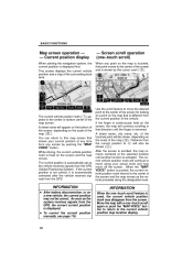
...the "MAP/VOICE" button to return to shown ( 3 ). The current position is automatically set as the system receives signals from the GPS, the correct current position is different from will also be the current position to the current vehicle position map location display. 30 If ...or bottom center of the map ( 2 ). The current vehicle position mark ( 1 ) appears in that shows your actual route and may disappear from the GPS (Global Positioning System). A street name, city name, etc. D To correct the current position manually, see page 118. BASIC FUNCTIONS Map screen operation - ...
...the "MAP/VOICE" button to return to shown ( 3 ). The current position is automatically set as the system receives signals from the GPS, the correct current position is different from will also be the current position to the current vehicle position map location display. 30 If ...or bottom center of the map ( 2 ). The current vehicle position mark ( 1 ) appears in that shows your actual route and may disappear from the GPS (Global Positioning System). A street name, city name, etc. D To correct the current position manually, see page 118. BASIC FUNCTIONS Map screen operation - ...

Navigation Manual
Page 61
...": A route by which you travel by ferry, the route guidance shows a sea route. "Quick1": Recommended route. "Info.": To display the following information about each of GPS signals, it is automatically corrected. 1. Upon reception of the 3 routes. 67 "Quick2": Alternative route.
...": A route by which you travel by ferry, the route guidance shows a sea route. "Quick1": Recommended route. "Info.": To display the following information about each of GPS signals, it is automatically corrected. 1. Upon reception of the 3 routes. 67 "Quick2": Alternative route.
Navigation Manual
Page 68
... One−way road One−way road ∗: The system indicates a U−turn if the distance between two one−way roads (of poor GPS signal reception), the voice guidance may be made early or delayed. "You have arrived at your destination.
... One−way road One−way road ∗: The system indicates a U−turn if the distance between two one−way roads (of poor GPS signal reception), the voice guidance may be made early or delayed. "You have arrived at your destination.
Navigation Manual
Page 113
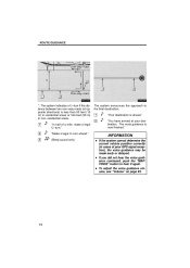
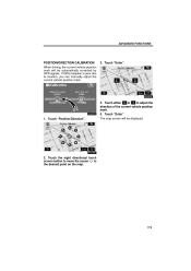
If GPS reception is poor due to adjust the direction of the current vehicle position mark. 5. The map screen will be displayed. 2. ADVANCED FUNCTIONS POSITION/DIRECTION CALIBRATION When driving, the current vehicle position mark will be automatically corrected by GPS signals. Touch "Position/Direction". 4. Touch "Enter". Touch "Enter". 1. Touch either or to location, you can manually adjust the current vehicle position mark. 3. Touch the eight directional touch screen button to move the cursor to the desired point on the map. 119
If GPS reception is poor due to adjust the direction of the current vehicle position mark. 5. The map screen will be displayed. 2. ADVANCED FUNCTIONS POSITION/DIRECTION CALIBRATION When driving, the current vehicle position mark will be automatically corrected by GPS signals. Touch "Position/Direction". 4. Touch "Enter". Touch "Enter". 1. Touch either or to location, you can manually adjust the current vehicle position mark. 3. Touch the eight directional touch screen button to move the cursor to the desired point on the map. 119

Navigation Manual
Page 172
... the current vehicle position using 4 or more satellites, and in some case 3 satellites. The GPS satellites may obstruct the GPS signals. However, the accurate position may obstruct the GPS signals. Department of the antenna in the instrument panel. Tunnels, tall buildings, trucks, or even... the placement of objects on the instrument panel may not be shown depending on vehicles equipped with GPS signal reception of Defense provides an accurate current vehicle position, normally using satellite signals, various vehicle signals, map data, etc. We...
... the current vehicle position using 4 or more satellites, and in some case 3 satellites. The GPS satellites may obstruct the GPS signals. However, the accurate position may obstruct the GPS signals. Department of the antenna in the instrument panel. Tunnels, tall buildings, trucks, or even... the placement of objects on the instrument panel may not be shown depending on vehicles equipped with GPS signal reception of Defense provides an accurate current vehicle position, normally using satellite signals, various vehicle signals, map data, etc. We...
Navigation Manual
Page 173
... may not be shown or announced. D When driving on the opposite side of direction by ferry or vehicle carrier. INFORMATION If your vehicle cannot receive GPS signals, you set more . For information on setting the current position calibration, see page 118. (b) Inappropriate route guidance may occur in the following cases: D When...
... may not be shown or announced. D When driving on the opposite side of direction by ferry or vehicle carrier. INFORMATION If your vehicle cannot receive GPS signals, you set more . For information on setting the current position calibration, see page 118. (b) Inappropriate route guidance may occur in the following cases: D When...
Navigation Manual
Page 187
... be faster than the calculated routes. The system will announce the distance remaining and the direction to select efficient routes from the Global Positioning System (GPS) operated by the U.S. Department of the Navigation System. The system uses DENSO maps. The navigation system is not in the database, you can enter the...
... be faster than the calculated routes. The system will announce the distance remaining and the direction to select efficient routes from the Global Positioning System (GPS) operated by the U.S. Department of the Navigation System. The system uses DENSO maps. The navigation system is not in the database, you can enter the...
Navigation Manual
Page 192
...They are not displayed. Touch this button to change the screen mode. Touch this button to display the "Information" screen. XMr NavTraffic mark "GPS" mark (Global Positioning System) This mark is displayed when XMr NavTraffic information is displayed. 75 120 17 18 178 6 Touch this button to ...destination, and the to register the current position or the cursor position as a memory point. Whenever the vehicle is receiving signals from the GPS, this button to display the foot print map and the building information. Some of Interest to reduce the map scale. Touch this mark...
...They are not displayed. Touch this button to change the screen mode. Touch this button to display the "Information" screen. XMr NavTraffic mark "GPS" mark (Global Positioning System) This mark is displayed when XMr NavTraffic information is displayed. 75 120 17 18 178 6 Touch this button to ...destination, and the to register the current position or the cursor position as a memory point. Whenever the vehicle is receiving signals from the GPS, this button to display the foot print map and the building information. Some of Interest to reduce the map scale. Touch this mark...

